Written and Fact-checked by Whereig Editors, Reviewed by Mukesh Kumar| Last Updated On: May 11, 2026
Map of Anne Arundel County - Anne Arundel County is a county located in the U.S. state of Maryland. Anne Arundel County Map showing cities, highways, important places and water bodies. Get Where is Anne Arundel County located in the map, major cities in Anne Arundel county, population, areas, and places of interest.
Map of Anne Arundel County, Maryland
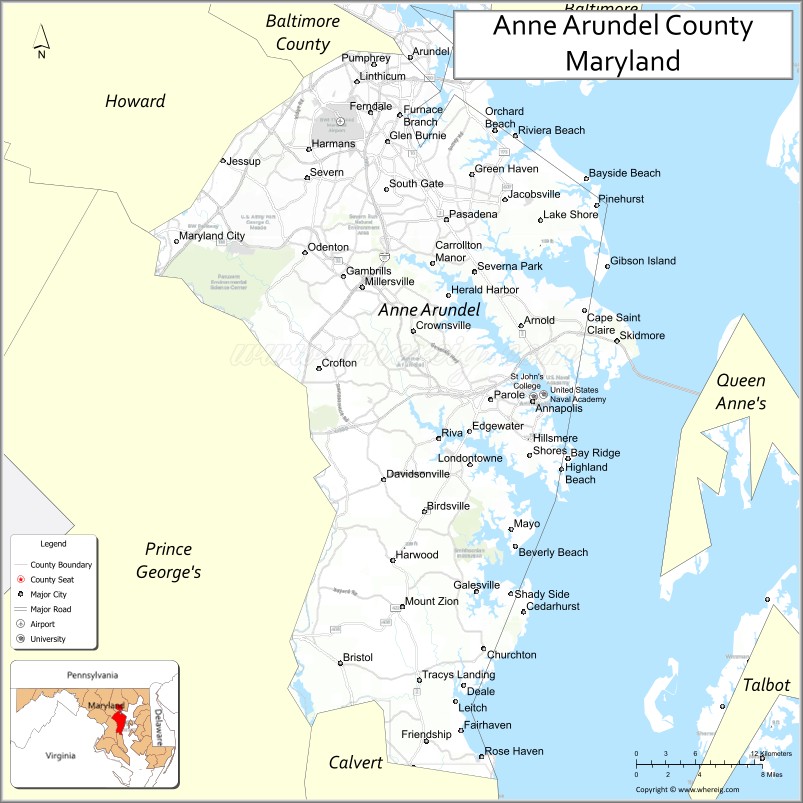
About Anne Arundel County Map, Alabama: The map showing the county boundary, county seat, major cities, highways, water bodies and neighbouring counties.
More Maryland Maps & Info
Map of Anne Arundel County, Maryland
Anne Arundel County is a county located in the U.S. state of Maryland. It's county seat is Annapolis. As per 2020 census, the population of Anne Arundel County is 590336 people and population density is square miles. According to the United States Census Bureau, the county has a total area of 588 sq mi (1,523 km2). Anne Arundel County was established on 1650.
Anne Arundel County Facts
| Continent | North America |
| Country | United States |
| State | Maryland |
| County Seat | Annapolis |
| Largest City/Town | Glen Burnie |
| Established | 1650 |
| Total Area | 588 sq mi (1,523 sq km) |
| Land Area | 415 sq mi (1,075 sq km) |
| Water Area | 173 sq mi (448 sq km) |
| Population | 588,261 (Census 2020) |
| Population Density | 1,417 people per sq mi |
| Time Zone | Eastern Time Zone (ET) |
| Major Highways | Interstate 97, U.S. Route 50, U.S. Route 301, Maryland Route 2 |
| Major Rivers | Severn River, Patuxent River, South River |
| Neighboring Counties | Baltimore County, Howard County, Prince George’s County, Calvert County, Queen Anne’s County |
| Famous For | Maryland state capital, Chesapeake Bay, U.S. Naval Academy, waterfront communities, boating |
| Top Attractions | United States Naval Academy, Historic Annapolis, Sandy Point State Park, Chesapeake Bay Bridge, Maryland Renaissance Festival |
| Official Website | Official Website |
About Anne Arundel County, Maryland
Anne Arundel County is located in central Maryland in the United States along the Chesapeake Bay and was established in 1650. The county seat is Annapolis, the capital of Maryland, while Glen Burnie is the largest community. The county is known for its historic waterfront towns, maritime culture, naval history, Chesapeake Bay recreation, and proximity to Baltimore and Washington, D.C.
Cities and Towns in Anne Arundel County, Maryland
| City/Town | Population (Census 2020) | Latitude & Longitude |
|---|---|---|
| Annapolis (county seat) | 40,812 | 38.9784°N, 76.4922°W |
| Glen Burnie | 72,891 | 39.1626°N, 76.6247°W |
| Severna Park | 39,223 | 39.0712°N, 76.5450°W |
| Crofton | 29,136 | 39.0018°N, 76.6875°W |
| Arnold | 24,367 | 39.0321°N, 76.5027°W |
| Pasadena | 30,114 | 39.1073°N, 76.5711°W |
| Odenton | 43,847 | 39.0840°N, 76.7000°W |
| Edgewater | 9,864 | 38.9368°N, 76.5686°W |
| Laurel (partly) | 25,060 | 39.0993°N, 76.8483°W |
| Deale | 4,943 | 38.7768°N, 76.5486°W |
Golf Courses in Anne Arundel County, Maryland
| Golf Course | Location | Latitude & Longitude |
|---|---|---|
| Compass Pointe Golf Courses | Pasadena | 39.1294°N, 76.5760°W |
| Eisenhower Golf Course | Annapolis | 38.9695°N, 76.5947°W |
| Crofton Country Club | Crofton | 39.0042°N, 76.6901°W |
Roads and Highways in Anne Arundel County
Major highways connect the county with Baltimore, Washington, D.C., and the Eastern Shore of Maryland.
- Interstate 97 - primary highway linking Annapolis with Baltimore
- U.S. Route 50 - major east-west highway connecting the Chesapeake Bay Bridge and Washington, D.C.
- U.S. Route 301 - regional route through central Maryland and Chesapeake regions
- Maryland Route 2 - scenic route serving Annapolis and waterfront communities
- Maryland Route 100 - connector highway linking western and eastern suburbs
Neighboring Counties of Anne Arundel County
- Baltimore County (north)
- Howard County (northwest)
- Prince George’s County (west)
- Calvert County (south)
- Queen Anne’s County (east across Chesapeake Bay)
Top Attractions in Anne Arundel County, Maryland
The county offers waterfront recreation, historic attractions, and Chesapeake Bay destinations.
- United States Naval Academy - historic military academy and major Annapolis landmark
- Historic Annapolis - colonial architecture, museums, restaurants, and waterfront shopping
- Sandy Point State Park - Chesapeake Bay beaches, boating, fishing, and picnic areas
- Chesapeake Bay Bridge - iconic bridge connecting central Maryland with the Eastern Shore
- Maryland Renaissance Festival - popular annual cultural and entertainment festival
- Quiet Waters Park - trails, gardens, kayaking, and outdoor recreation near Annapolis
- Thomas Point Shoal Lighthouse - historic Chesapeake Bay lighthouse accessible by tour
- Maritime Museums and Waterfront Districts - exhibits on naval and Chesapeake Bay history
- Boating and Sailing Areas - marinas and waterfront recreation throughout the county
- Fort Smallwood Park - waterfront park with fishing piers and scenic bay views
Distance from Anne Arundel County to Nearby Cities
The following distances are measured by road (driving).
- Annapolis to Baltimore (Baltimore City), Maryland - 31 mi (50 km)
- Annapolis to Washington, D.C. - 33 mi (53 km)
- Annapolis to Frederick (Frederick County), Maryland - 63 mi (101 km)
- Annapolis to Ocean City (Worcester County), Maryland - 128 mi (206 km)
- Annapolis to Wilmington (New Castle County), Delaware - 88 mi (142 km)
- Annapolis to Philadelphia (Philadelphia County), Pennsylvania - 129 mi (208 km)
- Annapolis to Richmond (Richmond City), Virginia - 146 mi (235 km)
- Annapolis to Norfolk (Norfolk City), Virginia - 218 mi (351 km)
- Annapolis to New York City (New York County), New York - 224 mi (360 km)
- Annapolis to Pittsburgh (Allegheny County), Pennsylvania - 245 mi (394 km)
- Annapolis to Charlotte (Mecklenburg County), North Carolina - 430 mi (692 km)
- Annapolis to Boston (Suffolk County), Massachusetts - 430 mi (692 km)
FAQs about Anne Arundel County
Anne Arundel County is located in central Maryland along the Chesapeake Bay.
Anne Arundel County has a population of 588,261 according to the Census 2020.
The county is known for Annapolis, the Chesapeake Bay, the U.S. Naval Academy, and waterfront recreation.
Major highways include Interstate 97, U.S. Route 50, U.S. Route 301, and Maryland Route 2.
Yes, Anne Arundel County has several golf facilities including Compass Pointe Golf Courses and Eisenhower Golf Course.
References
- QuickFacts - U.S. Census Bureau
- United States Census Bureau
- United States Geological Survey (USGS)
- National Geodetic Survey
- Official Website
- Allegany County Map
- Anne Arundel County Map
- Baltimore County Map
- Calvert County Map
- Caroline County Map
- Carroll County Map
- Cecil County Map
- Charles County Map
- Dorchester County Map
- Frederick County Map
- Garrett County Map
- Harford County Map
- Howard County Map
- Kent County Map
- Montgomery County Map
- Prince George's County Map
- Queen Anne's County Map
- St Mary's County Map
- Somerset County Map
- Talbot County Map
- Washington County Map
- Wicomico County Map
- Worcester County Map
- Baltimore City County Map
- Alabama Counties
- Alaska boroughs
- Arizona Counties
- Arkansas Counties
- California County Map
- Colorado Counties
- Connecticut Counties
- Delaware Counties
- Florida County Map
- Georgia County Map
- Hawaii Counties
- Idaho Counties
- Illinois Counties
- Indiana Counties
- Iowa Counties
- Kansas Counties
- Kentucky Counties
- Louisiana Counties
- Maine Counties
- Maryland Counties
- Massachusetts Counties
- Michigan County Map
- Minnesota Counties
- Mississippi Counties
- Missouri Counties
- Montana Counties
- Nebraska Counties
- Nevada Counties
- New York Counties
- New Hampshire Counties
- New Jersey Counties
- New Mexico Counties
- North Carolina Counties
- North Dakota Counties
- Ohio County Map
- Oklahoma Counties
- Oregon Counties
- Pennsylvania Counties
- Rhode Island Counties
- South Carolina Counties
- South Dakota Counties
- Map of Tennessee
- Texas County Map
- Utah Counties
- Vermont Counties
- Virginia Counties
- Washington Counties
- West Virginia Counties
- Wisconsin Counties
- Wyoming Counties