Written and Fact-checked by Whereig Editors, Reviewed by Mukesh Kumar| Last Updated On: May 11, 2026
Map of Allegany County - Allegany County is a county located in the U.S. state of Maryland. Allegany County Map showing cities, highways, important places and water bodies. Get Where is Allegany County located in the map, major cities in Allegany county, population, areas, and places of interest.
Map of Allegany County, Maryland
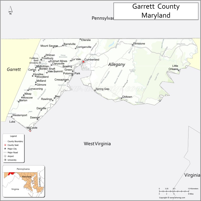
About Allegany County Map, Alabama: The map showing the county boundary, county seat, major cities, highways, water bodies and neighbouring counties.
More Maryland Maps & Info
Map of Allegany County, Maryland
Allegany County is a county located in the U.S. state of Maryland. It's county seat is Cumberland. As per 2020 census, the population of Allegany County is 67729 people and population density is square miles. According to the United States Census Bureau, the county has a total area of 430 sq mi (1,114 km2). Allegany County was established on 1789.
Allegany County Facts
| Continent | North America |
| Country | United States |
| State | Maryland |
| County Seat | Cumberland |
| Largest City/Town | Cumberland |
| Established | 1789 |
| Total Area | 430 sq mi (1,114 sq km) |
| Land Area | 424 sq mi (1,098 sq km) |
| Water Area | 6 sq mi (16 sq km) |
| Population | 68,106 (Census 2020) |
| Population Density | 160.6 people per sq mi |
| Time Zone | Eastern Time Zone (ET) |
| Major Highways | Interstate 68, U.S. Route 40, U.S. Route 220, Maryland Route 36 |
| Major Rivers | Potomac River, North Branch Potomac River |
| Neighboring Counties | Garrett County, Washington County, Mineral County (West Virginia), Bedford County (Pennsylvania) |
| Famous For | Appalachian Mountains, C&O Canal, outdoor recreation, railroads, historic Cumberland |
| Top Attractions | C&O Canal National Historical Park, Rocky Gap State Park, Great Allegheny Passage, Western Maryland Scenic Railroad, Green Ridge State Forest |
| Official Website | Official Website |
About Allegany County, Maryland
Allegany County is located in western Maryland in the United States within the Appalachian Mountain region and was established in 1789. The county seat and largest city is Cumberland. The county is known for mountain scenery, outdoor recreation, historic transportation routes, railroads, and its connection to the Chesapeake and Ohio Canal.
Cities and Towns in Allegany County, Maryland
| City/Town | Population (Census 2020) | Latitude & Longitude |
|---|---|---|
| Cumberland (county seat) | 19,075 | 39.6529°N, 78.7625°W |
| Frostburg | 7,123 | 39.6581°N, 78.9284°W |
| Lonaconing | 1,118 | 39.5659°N, 78.9792°W |
| Midland | 446 | 39.5737°N, 78.9461°W |
| Westernport | 1,888 | 39.4854°N, 79.0406°W |
| LaVale | 3,551 | 39.6554°N, 78.8106°W |
| Mount Savage | 873 | 39.6998°N, 78.8767°W |
| Barton | 457 | 39.5518°N, 79.0189°W |
| Bel Air | 1,032 | 39.6550°N, 78.8420°W |
| Corriganville | 455 | 39.6587°N, 78.7920°W |
Golf Courses in Allegany County, Maryland
| Golf Course | Location | Latitude & Longitude |
|---|---|---|
| Rocky Gap Casino Resort Golf Course | Flintstone | 39.7032°N, 78.5741°W |
| Mapleside Golf Course | Cumberland | 39.6614°N, 78.7745°W |
| Fore Sisters Golf Course | Cumberland | 39.6498°N, 78.7562°W |
Roads and Highways in Allegany County
Major highways connect the county with western Maryland, Pennsylvania, and West Virginia.
- Interstate 68 - major east-west interstate crossing the Appalachian region through Cumberland
- U.S. Route 40 - historic National Road through mountain communities and scenic areas
- U.S. Route 220 - regional highway connecting Cumberland with Pennsylvania and West Virginia
- Maryland Route 36 - scenic mountain route serving Frostburg and mining towns
- Maryland Route 51 - connector route through Potomac River communities
Neighboring Counties of Allegany County
- Garrett County (west)
- Washington County (east)
- Mineral County, West Virginia (south)
- Bedford County, Pennsylvania (north)
Top Attractions in Allegany County, Maryland
The county offers mountain recreation, historic transportation sites, and scenic Appalachian landscapes.
- C&O Canal National Historical Park - historic canal towpaths, hiking, and cycling routes along the Potomac River
- Rocky Gap State Park - lakeside recreation with camping, hiking, boating, and fishing
- Great Allegheny Passage - popular rail trail connecting Cumberland with Pittsburgh
- Western Maryland Scenic Railroad - heritage train rides through mountain landscapes
- Green Ridge State Forest - Maryland’s largest state forest with camping and wildlife observation
- Historic Downtown Cumberland - preserved architecture, museums, restaurants, and arts venues
- Frostburg State University Area - educational and cultural attractions in Frostburg
- Dan’s Mountain State Park - scenic overlooks, hiking, and outdoor recreation
- Mount Savage Historic District - former iron and railroad town with historic landmarks
- Potomac River Recreation Areas - fishing, kayaking, and photography opportunities
Distance from Allegany County to Nearby Cities
The following distances are measured by road (driving).
- Cumberland to Hagerstown (Washington County), Maryland - 65 mi (105 km)
- Cumberland to Baltimore (Baltimore City), Maryland - 135 mi (217 km)
- Cumberland to Washington, D.C. - 140 mi (225 km)
- Cumberland to Pittsburgh (Allegheny County), Pennsylvania - 115 mi (185 km)
- Cumberland to Morgantown (Monongalia County), West Virginia - 79 mi (127 km)
- Cumberland to Winchester (Frederick County), Virginia - 73 mi (117 km)
- Cumberland to Harrisburg (Dauphin County), Pennsylvania - 132 mi (212 km)
- Cumberland to Philadelphia (Philadelphia County), Pennsylvania - 215 mi (346 km)
- Cumberland to Richmond (Richmond City), Virginia - 233 mi (375 km)
- Cumberland to Cleveland (Cuyahoga County), Ohio - 250 mi (402 km)
- Cumberland to Columbus (Franklin County), Ohio - 240 mi (386 km)
- Cumberland to New York City (New York County), New York - 305 mi (491 km)
FAQs about Allegany County
Allegany County is located in western Maryland within the Appalachian Mountain region.
Allegany County has a population of 68,106 according to the Census 2020.
The county is known for mountain recreation, the C&O Canal, scenic railroads, and Appalachian heritage.
Major highways include Interstate 68, U.S. Route 40, U.S. Route 220, and Maryland Route 36.
Yes, Allegany County has golf facilities including Rocky Gap Casino Resort Golf Course and Mapleside Golf Course.
References
- QuickFacts - U.S. Census Bureau
- United States Census Bureau
- United States Geological Survey (USGS)
- National Geodetic Survey
- Official Website
- Allegany County Map
- Anne Arundel County Map
- Baltimore County Map
- Calvert County Map
- Caroline County Map
- Carroll County Map
- Cecil County Map
- Charles County Map
- Dorchester County Map
- Frederick County Map
- Garrett County Map
- Harford County Map
- Howard County Map
- Kent County Map
- Montgomery County Map
- Prince George's County Map
- Queen Anne's County Map
- St Mary's County Map
- Somerset County Map
- Talbot County Map
- Washington County Map
- Wicomico County Map
- Worcester County Map
- Baltimore City County Map
- Alabama Counties
- Alaska boroughs
- Arizona Counties
- Arkansas Counties
- California County Map
- Colorado Counties
- Connecticut Counties
- Delaware Counties
- Florida County Map
- Georgia County Map
- Hawaii Counties
- Idaho Counties
- Illinois Counties
- Indiana Counties
- Iowa Counties
- Kansas Counties
- Kentucky Counties
- Louisiana Counties
- Maine Counties
- Maryland Counties
- Massachusetts Counties
- Michigan County Map
- Minnesota Counties
- Mississippi Counties
- Missouri Counties
- Montana Counties
- Nebraska Counties
- Nevada Counties
- New York Counties
- New Hampshire Counties
- New Jersey Counties
- New Mexico Counties
- North Carolina Counties
- North Dakota Counties
- Ohio County Map
- Oklahoma Counties
- Oregon Counties
- Pennsylvania Counties
- Rhode Island Counties
- South Carolina Counties
- South Dakota Counties
- Map of Tennessee
- Texas County Map
- Utah Counties
- Vermont Counties
- Virginia Counties
- Washington Counties
- West Virginia Counties
- Wisconsin Counties
- Wyoming Counties