Written and Fact-checked by Whereig Editors, Reviewed by Mukesh Kumar| Last Updated On: May 11, 2026
Map of Kent County - Kent County is a county located in the U.S. state of Maryland. Kent County Map showing cities, highways, important places and water bodies. Get Where is Kent County located in the map, major cities in Kent county, population, areas, and places of interest.
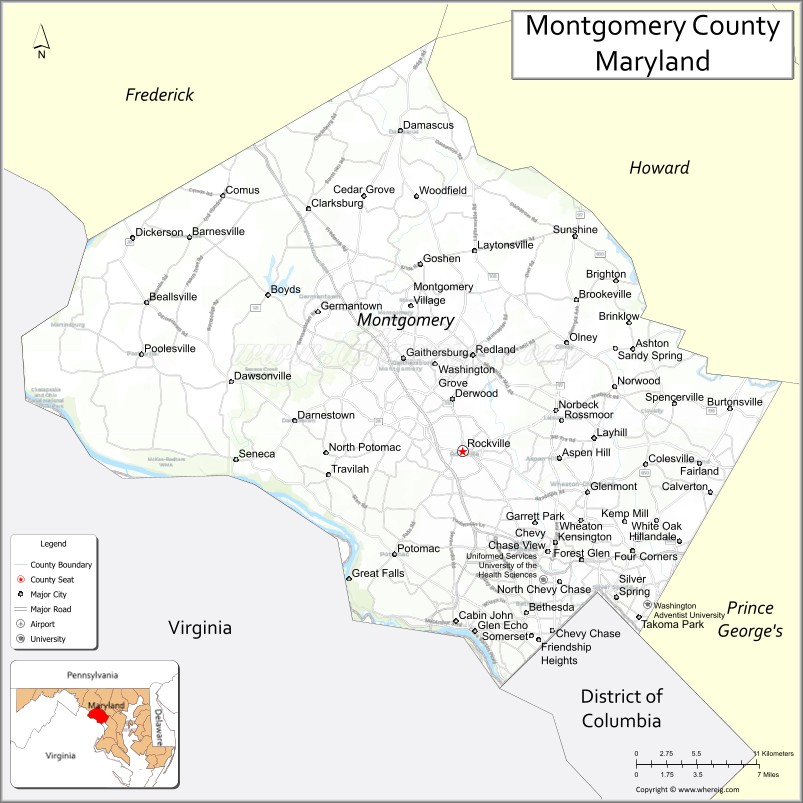
Map of Montgomery County, Maryland
About Kent County Map, Alabama: The map showing the county boundary, county seat, major cities, highways, water bodies and neighbouring counties.
More Maryland Maps & Info
Map of Montgomery County, Maryland
Montgomery County is a county located in the U.S. state of Maryland. It's county seat is Rockville. As per 2020 census, the population of Montgomery County is 1054827 people and population density is square miles. According to the United States Census Bureau, the county has a total area of 507 sq mi (1,313 km2). Montgomery County was established on 1776.
Montgomery County Facts
| Continent | North America |
| Country | United States |
| State | Maryland |
| County Seat | Rockville |
| Largest City/Town | Germantown |
| Established | 1776 |
| Total Area | 507 sq mi (1,313 sq km) |
| Land Area | 491 sq mi (1,272 sq km) |
| Water Area | 16 sq mi (41 sq km) |
| Population | 1,062,061 (Census 2020) |
| Population Density | 2,163 people per sq mi |
| Time Zone | Eastern Time Zone (ET) |
| Major Highways | Interstate 270, Interstate 495, U.S. Route 29, Maryland Route 200 |
| Major Rivers | Potomac River, Patuxent River, Rock Creek |
| Neighboring Counties | Frederick County, Howard County, Prince George’s County, Fairfax County (Virginia), Loudoun County (Virginia), Washington, D.C. |
| Famous For | Washington D.C. suburbs, biotechnology, education, diverse communities, parks and cultural attractions |
| Top Attractions | Great Falls Park nearby, Brookside Gardens, Glenstone Museum, C&O Canal, Rock Creek Regional Park |
| Official Website | Official Website |
About Montgomery County, Maryland
Montgomery County is located in central Maryland in the United States bordering Washington, D.C., and was established in 1776. The county seat is Rockville, while Germantown is the largest community by population. The county is known for its highly educated population, biotechnology industry, diverse suburban communities, major parks, and strong economic connection to the nation’s capital.
Cities and Communities in Montgomery County, Maryland
| City/Community | Population (Census 2020) | Latitude & Longitude |
|---|---|---|
| Rockville (county seat) | 67,117 | 39.0839°N, 77.1528°W |
| Germantown | 91,249 | 39.1732°N, 77.2717°W |
| Silver Spring | 81,015 | 38.9907°N, 77.0261°W |
| Bethesda | 68,056 | 38.9847°N, 77.0947°W |
| Gaithersburg | 69,657 | 39.1434°N, 77.2014°W |
| Wheaton | 54,839 | 39.0398°N, 77.0553°W |
| Takoma Park | 17,629 | 38.9779°N, 77.0075°W |
| Olney | 35,820 | 39.1532°N, 77.0669°W |
| Chevy Chase | 10,607 | 38.9648°N, 77.0678°W |
| Potomac | 46,581 | 39.0182°N, 77.2086°W |
Golf Courses in Montgomery County, Maryland
| Golf Course | Location | Latitude & Longitude |
|---|---|---|
| Falls Road Golf Course | Potomac | 39.0640°N, 77.1772°W |
| Needwood Golf Course | Derwood | 39.1185°N, 77.1544°W |
| Little Bennett Golf Course | Clarksburg | 39.2490°N, 77.2861°W |
Roads and Highways in Montgomery County
Major highways connect the county with Washington, D.C., northern Virginia, and surrounding Maryland communities.
- Interstate 270 - major commuter interstate linking Montgomery County with Frederick and Washington metropolitan areas
- Interstate 495 - Capital Beltway surrounding Washington, D.C.
- U.S. Route 29 - important north-south commuter route through Silver Spring and Columbia corridors
- Maryland Route 200 (Intercounty Connector) - toll highway connecting Montgomery and Prince George’s counties
- Maryland Route 355 - historic roadway serving Rockville, Gaithersburg, and Germantown
Neighboring Counties of Montgomery County
- Frederick County (northwest)
- Howard County (northeast)
- Prince George’s County (east)
- Fairfax County, Virginia (southwest)
- Loudoun County, Virginia (west)
- Washington, D.C. (south)
Top Attractions in Montgomery County, Maryland
The county offers parks, museums, shopping districts, and major cultural attractions near Washington, D.C.
- Great Falls Park nearby - dramatic waterfalls and hiking trails along the Potomac River
- Brookside Gardens - botanical gardens with walking trails and seasonal flower displays
- Glenstone Museum - modern art museum with landscaped outdoor exhibits
- C&O Canal National Historical Park - biking, hiking, boating, and historic canal scenery
- Rock Creek Regional Park - lakes, trails, picnic areas, and nature recreation
- Downtown Bethesda - restaurants, arts venues, and shopping districts
- Strathmore Music Center - performing arts venue hosting concerts and cultural events
- Cabin John Regional Park - playgrounds, miniature train rides, and outdoor recreation
- National Capital Trolley Museum - exhibits on historic streetcars and transportation history
- Seneca Creek State Park - boating, hiking, and nature activities
Distance from Montgomery County to Nearby Cities
The following distances are measured by road (driving).
- Rockville to Washington, D.C. - 15 mi (24 km)
- Rockville to Baltimore (Baltimore City), Maryland - 41 mi (66 km)
- Rockville to Frederick (Frederick County), Maryland - 31 mi (50 km)
- Rockville to Annapolis (Anne Arundel County), Maryland - 47 mi (76 km)
- Rockville to Richmond (Richmond City), Virginia - 109 mi (175 km)
- Rockville to Philadelphia (Philadelphia County), Pennsylvania - 144 mi (232 km)
- Rockville to Norfolk (Norfolk City), Virginia - 214 mi (344 km)
- Rockville to Pittsburgh (Allegheny County), Pennsylvania - 226 mi (364 km)
- Rockville to New York City (New York County), New York - 229 mi (369 km)
- Rockville to Charlotte (Mecklenburg County), North Carolina - 398 mi (641 km)
- Rockville to Boston (Suffolk County), Massachusetts - 441 mi (710 km)
- Rockville to Cleveland (Cuyahoga County), Ohio - 373 mi (600 km)
FAQs about Montgomery County
Montgomery County is located in central Maryland bordering Washington, D.C.
Montgomery County has a population of 1,062,061 according to the Census 2020.
The county is known for biotechnology, education, diverse suburban communities, and proximity to Washington, D.C.
Major highways include Interstate 270, Interstate 495, U.S. Route 29, and Maryland Route 200.
Yes, Montgomery County has golf facilities including Falls Road Golf Course and Needwood Golf Course.
References
- QuickFacts - U.S. Census Bureau
- United States Census Bureau
- United States Geological Survey (USGS)
- National Geodetic Survey
- Official Website
- Allegany County Map
- Anne Arundel County Map
- Baltimore County Map
- Calvert County Map
- Caroline County Map
- Carroll County Map
- Cecil County Map
- Charles County Map
- Dorchester County Map
- Frederick County Map
- Garrett County Map
- Harford County Map
- Howard County Map
- Kent County Map
- Montgomery County Map
- Prince George's County Map
- Queen Anne's County Map
- St Mary's County Map
- Somerset County Map
- Talbot County Map
- Washington County Map
- Wicomico County Map
- Worcester County Map
- Baltimore City County Map
- Alabama Counties
- Alaska boroughs
- Arizona Counties
- Arkansas Counties
- California County Map
- Colorado Counties
- Connecticut Counties
- Delaware Counties
- Florida County Map
- Georgia County Map
- Hawaii Counties
- Idaho Counties
- Illinois Counties
- Indiana Counties
- Iowa Counties
- Kansas Counties
- Kentucky Counties
- Louisiana Counties
- Maine Counties
- Maryland Counties
- Massachusetts Counties
- Michigan County Map
- Minnesota Counties
- Mississippi Counties
- Missouri Counties
- Montana Counties
- Nebraska Counties
- Nevada Counties
- New York Counties
- New Hampshire Counties
- New Jersey Counties
- New Mexico Counties
- North Carolina Counties
- North Dakota Counties
- Ohio County Map
- Oklahoma Counties
- Oregon Counties
- Pennsylvania Counties
- Rhode Island Counties
- South Carolina Counties
- South Dakota Counties
- Map of Tennessee
- Texas County Map
- Utah Counties
- Vermont Counties
- Virginia Counties
- Washington Counties
- West Virginia Counties
- Wisconsin Counties
- Wyoming Counties