Written and Fact-checked by Whereig Editors, Reviewed by Mukesh Kumar| Last Updated On: May 11, 2026
Map of Baltimore City County - Baltimore City County is a county located in the U.S. state of Maryland. Baltimore City County Map showing cities, highways, important places and water bodies. Get Where is Baltimore City County located in the map, major cities in Baltimore City county, population, areas, and places of interest.
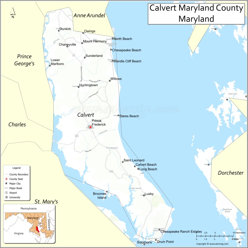
Map of Calvert County, Maryland
About Baltimore City County Map, Marylanda: The map showing the county boundary, county seat, major cities, highways, water bodies and neighbouring counties.
More Maryland Maps & Info
Map of Calvert County, Maryland
Calvert County is a county located in the U.S. state of Maryland. It's county seat is Prince Frederick. As per 2020 census, the population of Calvert County is 93928 people and population density is square miles. According to the United States Census Bureau, the county has a total area of 345 sq mi (894 km2). Calvert County was established on 1654.
Calvert County Facts
| Continent | North America |
| Country | United States |
| State | Maryland |
| County Seat | Prince Frederick |
| Largest City/Town | Prince Frederick |
| Established | 1654 |
| Total Area | 345 sq mi (894 sq km) |
| Land Area | 213 sq mi (552 sq km) |
| Water Area | 132 sq mi (342 sq km) |
| Population | 92,783 (Census 2020) |
| Population Density | 435.6 people per sq mi |
| Time Zone | Eastern Time Zone (ET) |
| Major Highways | Maryland Route 2, Maryland Route 4, Maryland Route 231, Maryland Route 765 |
| Major Rivers | Patuxent River, Chesapeake Bay |
| Neighboring Counties | Anne Arundel County, St. Mary’s County, Charles County |
| Famous For | Chesapeake Bay cliffs, fossil hunting, waterfront communities, beaches, maritime heritage |
| Top Attractions | Calvert Cliffs State Park, Chesapeake Beach, Drum Point Lighthouse, Flag Ponds Nature Park, Solomons Island nearby |
| Official Website | Official Website |
About Calvert County, Maryland
Calvert County is located in southern Maryland in the United States between the Chesapeake Bay and the Patuxent River and was established in 1654. The county seat and largest community is Prince Frederick. The county is known for scenic waterfronts, fossil-rich cliffs, boating, fishing, beaches, and Chesapeake Bay maritime culture.
Cities and Communities in Calvert County, Maryland
| City/Community | Population (Census 2020) | Latitude & Longitude |
|---|---|---|
| Prince Frederick (county seat) | 3,226 | 38.5404°N, 76.5844°W |
| Chesapeake Beach | 6,356 | 38.6868°N, 76.5347°W |
| North Beach | 2,978 | 38.7087°N, 76.5319°W |
| Dunkirk | 2,520 | 38.7212°N, 76.6605°W |
| Huntingtown | 3,446 | 38.6176°N, 76.6150°W |
| Lusby | 2,303 | 38.3890°N, 76.4386°W |
| Solomons | 2,368 | 38.3185°N, 76.4541°W |
| Owings | 2,148 | 38.7162°N, 76.6047°W |
| St. Leonard | 515 | 38.4507°N, 76.4952°W |
| Broomes Island | 405 | 38.3981°N, 76.5349°W |
Golf Courses in Calvert County, Maryland
| Golf Course | Location | Latitude & Longitude |
|---|---|---|
| Chesapeake Hills Golf Course | Lusby | 38.3864°N, 76.4420°W |
| Twin Shields Golf Club | Dunkirk | 38.7292°N, 76.6508°W |
| Battle Creek Cypress Swamp Golf Area | Prince Frederick | 38.5487°N, 76.5925°W |
Roads and Highways in Calvert County
Major highways connect the county with southern Maryland communities and the Baltimore-Washington metropolitan region.
- Maryland Route 2 - major north-south route through Chesapeake Bay communities
- Maryland Route 4 - primary highway linking Calvert County with Washington, D.C.
- Maryland Route 231 - regional connector route through rural and waterfront areas
- Maryland Route 765 - scenic roadway through coastal communities and historic districts
- Maryland Route 260 - connector route serving Chesapeake Beach and North Beach
Neighboring Counties of Calvert County
- Anne Arundel County (north)
- Charles County (west)
- St. Mary’s County (south)
Top Attractions in Calvert County, Maryland
The county offers waterfront recreation, beaches, fossil sites, and Chesapeake Bay attractions.
- Calvert Cliffs State Park - fossil hunting, hiking trails, beaches, and Chesapeake Bay scenery
- Chesapeake Beach - waterfront boardwalks, marinas, fishing, and family attractions
- Drum Point Lighthouse - historic lighthouse and maritime museum in Solomons
- Flag Ponds Nature Park - beaches, nature trails, birdwatching, and swimming areas
- Solomons Island nearby - waterfront restaurants, museums, and boating facilities
- Battle Creek Cypress Swamp Sanctuary - wetlands, boardwalks, and educational nature exhibits
- Calvert Marine Museum - exhibits on maritime history, paleontology, and regional culture
- North Beach Boardwalk - scenic bayfront promenade with shops and dining
- Fishing and Boating Areas - charter fishing and Chesapeake Bay recreation opportunities
- Historic Waterfront Villages - marinas, seafood restaurants, and Chesapeake culture
Distance from Calvert County to Nearby Cities
The following distances are measured by road (driving).
- Prince Frederick to Annapolis (Anne Arundel County), Maryland - 45 mi (72 km)
- Prince Frederick to Washington, D.C. - 54 mi (87 km)
- Prince Frederick to Baltimore (Baltimore City), Maryland - 67 mi (108 km)
- Prince Frederick to Alexandria (Alexandria City), Virginia - 58 mi (93 km)
- Prince Frederick to Richmond (Richmond City), Virginia - 120 mi (193 km)
- Prince Frederick to Ocean City (Worcester County), Maryland - 138 mi (222 km)
- Prince Frederick to Norfolk (Norfolk City), Virginia - 177 mi (285 km)
- Prince Frederick to Philadelphia (Philadelphia County), Pennsylvania - 156 mi (251 km)
- Prince Frederick to New York City (New York County), New York - 252 mi (406 km)
- Prince Frederick to Pittsburgh (Allegheny County), Pennsylvania - 292 mi (470 km)
- Prince Frederick to Charlotte (Mecklenburg County), North Carolina - 395 mi (636 km)
- Prince Frederick to Boston (Suffolk County), Massachusetts - 465 mi (748 km)
FAQs about Calvert County
Calvert County is located in southern Maryland between the Chesapeake Bay and the Patuxent River.
Calvert County has a population of 92,783 according to the Census 2020.
The county is known for Calvert Cliffs, fossil hunting, Chesapeake Bay waterfronts, and maritime heritage.
Major highways include Maryland Route 2, Maryland Route 4, Maryland Route 231, and Maryland Route 765.
Yes, Calvert County has golf facilities including Chesapeake Hills Golf Course and Twin Shields Golf Club.
References
- QuickFacts - U.S. Census Bureau
- United States Census Bureau
- United States Geological Survey (USGS)
- National Geodetic Survey
- Official Website
- Allegany County Map
- Anne Arundel County Map
- Baltimore County Map
- Calvert County Map
- Caroline County Map
- Carroll County Map
- Cecil County Map
- Charles County Map
- Dorchester County Map
- Frederick County Map
- Garrett County Map
- Harford County Map
- Howard County Map
- Kent County Map
- Montgomery County Map
- Prince George's County Map
- Queen Anne's County Map
- St Mary's County Map
- Somerset County Map
- Talbot County Map
- Washington County Map
- Wicomico County Map
- Worcester County Map
- Baltimore City County Map
- Alabama Counties
- Alaska boroughs
- Arizona Counties
- Arkansas Counties
- California County Map
- Colorado Counties
- Connecticut Counties
- Delaware Counties
- Florida County Map
- Georgia County Map
- Hawaii Counties
- Idaho Counties
- Illinois Counties
- Indiana Counties
- Iowa Counties
- Kansas Counties
- Kentucky Counties
- Louisiana Counties
- Maine Counties
- Maryland Counties
- Massachusetts Counties
- Michigan County Map
- Minnesota Counties
- Mississippi Counties
- Missouri Counties
- Montana Counties
- Nebraska Counties
- Nevada Counties
- New York Counties
- New Hampshire Counties
- New Jersey Counties
- New Mexico Counties
- North Carolina Counties
- North Dakota Counties
- Ohio County Map
- Oklahoma Counties
- Oregon Counties
- Pennsylvania Counties
- Rhode Island Counties
- South Carolina Counties
- South Dakota Counties
- Map of Tennessee
- Texas County Map
- Utah Counties
- Vermont Counties
- Virginia Counties
- Washington Counties
- West Virginia Counties
- Wisconsin Counties
- Wyoming Counties