Written and Fact-checked by Whereig Editors, Reviewed by Mukesh Kumar| Last Updated On: May 11, 2026
Map of Garrett County - Garrett County is a county located in the U.S. state of Maryland. Garrett County Map showing cities, highways, important places and water bodies. Get Where is Garrett County located in the map, major cities in Garrett county, population, areas, and places of interest.
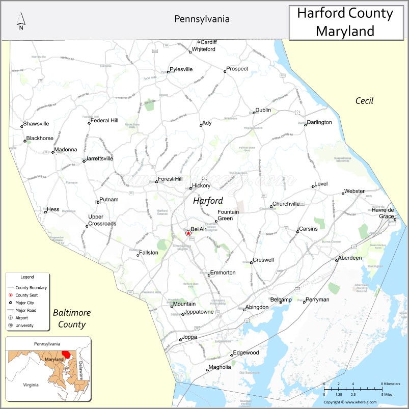
Map of Harford County, Maryland
About Garrett County Map, Alabama: The map showing the county boundary, county seat, major cities, highways, water bodies and neighbouring counties.
More Maryland Maps & Info
Map of Harford County, Maryland
Harford County is a county located in the U.S. state of Maryland. It's county seat is Bel Air. As per 2020 census, the population of Harford County is 262977 people and population density is square miles. According to the United States Census Bureau, the county has a total area of 527 sq mi (1,365 km2). Harford County was established on 1773.
Harford County Facts
| Continent | North America |
| Country | United States |
| State | Maryland |
| County Seat | Bel Air |
| Largest City/Town | Bel Air South |
| Established | 1773 |
| Total Area | 558 sq mi (1,445 sq km) |
| Land Area | 437 sq mi (1,132 sq km) |
| Water Area | 121 sq mi (313 sq km) |
| Population | 260,924 (Census 2020) |
| Population Density | 597 people per sq mi |
| Time Zone | Eastern Time Zone (ET) |
| Major Highways | Interstate 95, U.S. Route 1, U.S. Route 40, Maryland Route 24 |
| Major Rivers | Susquehanna River, Bush River, Gunpowder River |
| Neighboring Counties | Cecil County, Baltimore County, York County (Pennsylvania), Lancaster County (Pennsylvania) |
| Famous For | Chesapeake Bay waterfronts, military history, parks, suburban communities, outdoor recreation |
| Top Attractions | Aberdeen Proving Ground, Susquehanna State Park, Havre de Grace waterfront, Rocks State Park, Concord Point Lighthouse |
| Official Website | Official Website |
About Harford County, Maryland
Harford County is located in northeastern Maryland in the United States along the Chesapeake Bay and was established in 1773. The county seat is Bel Air, while Bel Air South is the largest community. The county is known for waterfront recreation, military installations, historic towns, parks, suburban neighborhoods, and scenic river landscapes.
Cities and Communities in Harford County, Maryland
| City/Community | Population (Census 2020) | Latitude & Longitude |
|---|---|---|
| Bel Air (county seat) | 10,661 | 39.5359°N, 76.3483°W |
| Bel Air South | 57,648 | 39.4993°N, 76.3216°W |
| Aberdeen | 16,254 | 39.5096°N, 76.1641°W |
| Havre de Grace | 14,807 | 39.5487°N, 76.0916°W |
| Edgewood | 25,595 | 39.4187°N, 76.2944°W |
| Joppatowne | 13,068 | 39.4576°N, 76.2330°W |
| Fallston | 9,306 | 39.5237°N, 76.4119°W |
| Forest Hill | 6,487 | 39.5854°N, 76.3877°W |
| Churchville | 2,896 | 39.5593°N, 76.2508°W |
| Perryman | 2,417 | 39.4623°N, 76.2150°W |
Golf Courses in Harford County, Maryland
| Golf Course | Location | Latitude & Longitude |
|---|---|---|
| Bulle Rock Golf Course | Havre de Grace | 39.5742°N, 76.1005°W |
| Maryland Golf and Country Clubs | Bel Air | 39.5404°N, 76.3567°W |
| Mountain Branch Golf Club | Joppa | 39.4338°N, 76.3579°W |
Roads and Highways in Harford County
Major highways connect the county with Baltimore, Philadelphia, and Chesapeake Bay communities.
- Interstate 95 - major East Coast interstate through Harford County
- U.S. Route 1 - historic north-south highway linking Maryland and Pennsylvania
- U.S. Route 40 - regional route through Aberdeen and Havre de Grace
- Maryland Route 24 - important connector highway serving Bel Air and suburban communities
- Maryland Route 22 - regional roadway linking rural and suburban areas
Neighboring Counties of Harford County
- Cecil County (east)
- Baltimore County (southwest)
- York County, Pennsylvania (north)
- Lancaster County, Pennsylvania (northeast)
Top Attractions in Harford County, Maryland
The county offers waterfront attractions, military history, parks, and outdoor recreation.
- Aberdeen Proving Ground - historic U.S. Army testing facility and military heritage area
- Susquehanna State Park - hiking, camping, fishing, and river recreation
- Havre de Grace Waterfront - marinas, boardwalks, restaurants, and Chesapeake Bay scenery
- Rocks State Park - hiking trails, forests, and the famous King and Queen Seat rock formation
- Concord Point Lighthouse - historic lighthouse overlooking the Susquehanna River
- Bulle Rock Golf Course - championship golf destination near Havre de Grace
- Steppingstone Farm Museum - agricultural exhibits and local heritage displays
- Ma & Pa Heritage Trail - scenic walking and biking trail through rural landscapes
- Fishing and Boating Areas - Chesapeake Bay and Susquehanna River recreation
- Historic Bel Air - local shops, restaurants, and community events
Distance from Harford County to Nearby Cities
The following distances are measured by road (driving).
- Bel Air to Baltimore (Baltimore City), Maryland - 29 mi (47 km)
- Bel Air to Wilmington (New Castle County), Delaware - 41 mi (66 km)
- Bel Air to Annapolis (Anne Arundel County), Maryland - 57 mi (92 km)
- Bel Air to Philadelphia (Philadelphia County), Pennsylvania - 67 mi (108 km)
- Bel Air to Washington, D.C. - 73 mi (117 km)
- Bel Air to Harrisburg (Dauphin County), Pennsylvania - 74 mi (119 km)
- Bel Air to Dover (Kent County), Delaware - 77 mi (124 km)
- Bel Air to Richmond (Richmond City), Virginia - 185 mi (298 km)
- Bel Air to New York City (New York County), New York - 154 mi (248 km)
- Bel Air to Norfolk (Norfolk City), Virginia - 263 mi (423 km)
- Bel Air to Pittsburgh (Allegheny County), Pennsylvania - 244 mi (393 km)
- Bel Air to Boston (Suffolk County), Massachusetts - 392 mi (631 km)
FAQs about Harford County
Harford County is located in northeastern Maryland along the Chesapeake Bay.
Harford County has a population of 260,924 according to the Census 2020.
The county is known for waterfront parks, military history, Chesapeake Bay recreation, and suburban communities.
Major highways include Interstate 95, U.S. Route 1, U.S. Route 40, and Maryland Route 24.
Yes, Harford County has golf facilities including Bulle Rock Golf Course and Mountain Branch Golf Club.
References
- QuickFacts - U.S. Census Bureau
- United States Census Bureau
- United States Geological Survey (USGS)
- National Geodetic Survey
- Official Website
- Allegany County Map
- Anne Arundel County Map
- Baltimore County Map
- Calvert County Map
- Caroline County Map
- Carroll County Map
- Cecil County Map
- Charles County Map
- Dorchester County Map
- Frederick County Map
- Garrett County Map
- Harford County Map
- Howard County Map
- Kent County Map
- Montgomery County Map
- Prince George's County Map
- Queen Anne's County Map
- St Mary's County Map
- Somerset County Map
- Talbot County Map
- Washington County Map
- Wicomico County Map
- Worcester County Map
- Baltimore City County Map
- Alabama Counties
- Alaska boroughs
- Arizona Counties
- Arkansas Counties
- California County Map
- Colorado Counties
- Connecticut Counties
- Delaware Counties
- Florida County Map
- Georgia County Map
- Hawaii Counties
- Idaho Counties
- Illinois Counties
- Indiana Counties
- Iowa Counties
- Kansas Counties
- Kentucky Counties
- Louisiana Counties
- Maine Counties
- Maryland Counties
- Massachusetts Counties
- Michigan County Map
- Minnesota Counties
- Mississippi Counties
- Missouri Counties
- Montana Counties
- Nebraska Counties
- Nevada Counties
- New York Counties
- New Hampshire Counties
- New Jersey Counties
- New Mexico Counties
- North Carolina Counties
- North Dakota Counties
- Ohio County Map
- Oklahoma Counties
- Oregon Counties
- Pennsylvania Counties
- Rhode Island Counties
- South Carolina Counties
- South Dakota Counties
- Map of Tennessee
- Texas County Map
- Utah Counties
- Vermont Counties
- Virginia Counties
- Washington Counties
- West Virginia Counties
- Wisconsin Counties
- Wyoming Counties