Written and Fact-checked by Whereig Editors, Reviewed by Mukesh Kumar| Last Updated On: May 11, 2026
Map of Caroline County - Caroline County is a county located in the U.S. state of Maryland. Caroline County Map showing cities, highways, important places and water bodies. Get Where is Caroline County located in the map, major cities in Caroline county, population, areas, and places of interest.
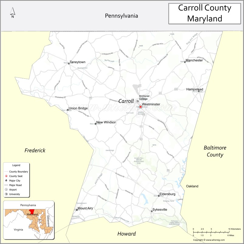
Map of Carroll County, Maryland
About Caroline County Map, Alabama: The map showing the county boundary, county seat, major cities, highways, water bodies and neighbouring counties.
More Maryland Maps & Info
Map of Carroll County, Maryland
Carroll County is a county located in the U.S. state of Maryland. It's county seat is Westminster. As per 2020 census, the population of Carroll County is 173873 people and population density is square miles. According to the United States Census Bureau, the county has a total area of 452 sq mi (1,171 km2). Carroll County was established on 1837.
Carroll County Facts
| Continent | North America |
| Country | United States |
| State | Maryland |
| County Seat | Westminster |
| Largest City/Town | Westminster |
| Established | 1837 |
| Total Area | 453 sq mi (1,173 sq km) |
| Land Area | 448 sq mi (1,160 sq km) |
| Water Area | 5 sq mi (13 sq km) |
| Population | 172,891 (Census 2020) |
| Population Density | 385.9 people per sq mi |
| Time Zone | Eastern Time Zone (ET) |
| Major Highways | Interstate 70 nearby, Maryland Route 26, Maryland Route 27, Maryland Route 140 |
| Major Rivers | Monocacy River, Patapsco River headwaters |
| Neighboring Counties | Baltimore County, Frederick County, Howard County, Adams County (Pennsylvania), York County (Pennsylvania) |
| Famous For | Rolling farmland, historic towns, Civil War history, agriculture, scenic countryside |
| Top Attractions | Piney Run Park, Hashawha Environmental Center, Union Mills Homestead, Carroll County Farm Museum, Westminster historic district |
| Official Website | Official Website |
About Carroll County, Maryland
Carroll County is located in north-central Maryland in the United States near the Pennsylvania border and was established in 1837. The county seat and largest city is Westminster. The county is known for rolling farmland, rural communities, Civil War history, agricultural heritage, and scenic countryside landscapes.
Cities and Towns in Carroll County, Maryland
| City/Town | Population (Census 2020) | Latitude & Longitude |
|---|---|---|
| Westminster (county seat) | 18,590 | 39.5754°N, 76.9958°W |
| Eldersburg | 32,582 | 39.4037°N, 76.9508°W |
| Taneytown | 7,234 | 39.6570°N, 77.1744°W |
| Mount Airy (partly) | 9,654 | 39.3762°N, 77.1544°W |
| Manchester | 5,215 | 39.6623°N, 76.8841°W |
| Hampstead | 6,323 | 39.6076°N, 76.8494°W |
| Sykesville | 4,436 | 39.3737°N, 76.9678°W |
| New Windsor | 1,365 | 39.5429°N, 77.1080°W |
| Union Bridge | 962 | 39.5682°N, 77.1766°W |
| Woodbine | 1,140 | 39.3748°N, 77.0569°W |
Golf Courses in Carroll County, Maryland
| Golf Course | Location | Latitude & Longitude |
|---|---|---|
| Wakefield Valley Golf Club | Westminster | 39.5887°N, 77.0154°W |
| Oakmont Green Golf Course | Hampstead | 39.6205°N, 76.8679°W |
| River Downs Golf Club | Finksburg | 39.5053°N, 76.8906°W |
Roads and Highways in Carroll County
Major highways connect the county with Baltimore, Frederick, and southern Pennsylvania.
- Interstate 70 nearby - major east-west interstate serving southern county connections
- Maryland Route 26 - regional route connecting Westminster with Frederick and Baltimore suburbs
- Maryland Route 27 - important north-south highway through Westminster and rural communities
- Maryland Route 140 - major route linking Westminster with Baltimore metropolitan areas
- Maryland Route 97 - scenic roadway connecting Carroll County with central Maryland regions
Neighboring Counties of Carroll County
- Baltimore County (east)
- Frederick County (west)
- Howard County (south)
- Adams County, Pennsylvania (northwest)
- York County, Pennsylvania (north)
Top Attractions in Carroll County, Maryland
The county offers historic attractions, parks, agricultural heritage, and outdoor recreation.
- Piney Run Park - boating, fishing, hiking, camping, and nature trails around Piney Run Reservoir
- Hashawha Environmental Center - environmental education center with trails and outdoor programs
- Union Mills Homestead - preserved historic farmstead and Civil War-era heritage site
- Carroll County Farm Museum - exhibits highlighting regional agriculture and rural history
- Historic Westminster - downtown district with shops, restaurants, and historic architecture
- Patapsco Valley Recreation Areas nearby - hiking, river activities, and scenic landscapes
- Taneytown Heritage Sites - local history museums and Civil War landmarks
- Wine Trails and Farms - local wineries and agricultural tourism destinations
- Bear Branch Nature Center - wildlife exhibits and educational programs
- Community Festivals and Farmers Markets - events celebrating local culture and agriculture
Distance from Carroll County to Nearby Cities
The following distances are measured by road (driving).
- Westminster to Baltimore (Baltimore City), Maryland - 36 mi (58 km)
- Westminster to Frederick (Frederick County), Maryland - 30 mi (48 km)
- Westminster to Washington, D.C. - 57 mi (92 km)
- Westminster to Gettysburg (Adams County), Pennsylvania - 28 mi (45 km)
- Westminster to Harrisburg (Dauphin County), Pennsylvania - 52 mi (84 km)
- Westminster to Annapolis (Anne Arundel County), Maryland - 58 mi (93 km)
- Westminster to Philadelphia (Philadelphia County), Pennsylvania - 105 mi (169 km)
- Westminster to Richmond (Richmond City), Virginia - 165 mi (266 km)
- Westminster to Pittsburgh (Allegheny County), Pennsylvania - 188 mi (303 km)
- Westminster to New York City (New York County), New York - 198 mi (319 km)
- Westminster to Norfolk (Norfolk City), Virginia - 258 mi (415 km)
- Westminster to Cleveland (Cuyahoga County), Ohio - 341 mi (549 km)
FAQs about Carroll County
Carroll County is located in north-central Maryland near the Pennsylvania border.
Carroll County has a population of 172,891 according to the Census 2020.
The county is known for rolling farmland, Civil War history, historic towns, and agricultural heritage.
Major highways include Maryland Route 26, Maryland Route 27, Maryland Route 140, and nearby Interstate 70.
Yes, Carroll County has golf facilities including Wakefield Valley Golf Club and Oakmont Green Golf Course.
References
- QuickFacts - U.S. Census Bureau
- United States Census Bureau
- United States Geological Survey (USGS)
- National Geodetic Survey
- Official Website
- Allegany County Map
- Anne Arundel County Map
- Baltimore County Map
- Calvert County Map
- Caroline County Map
- Carroll County Map
- Cecil County Map
- Charles County Map
- Dorchester County Map
- Frederick County Map
- Garrett County Map
- Harford County Map
- Howard County Map
- Kent County Map
- Montgomery County Map
- Prince George's County Map
- Queen Anne's County Map
- St Mary's County Map
- Somerset County Map
- Talbot County Map
- Washington County Map
- Wicomico County Map
- Worcester County Map
- Baltimore City County Map
- Alabama Counties
- Alaska boroughs
- Arizona Counties
- Arkansas Counties
- California County Map
- Colorado Counties
- Connecticut Counties
- Delaware Counties
- Florida County Map
- Georgia County Map
- Hawaii Counties
- Idaho Counties
- Illinois Counties
- Indiana Counties
- Iowa Counties
- Kansas Counties
- Kentucky Counties
- Louisiana Counties
- Maine Counties
- Maryland Counties
- Massachusetts Counties
- Michigan County Map
- Minnesota Counties
- Mississippi Counties
- Missouri Counties
- Montana Counties
- Nebraska Counties
- Nevada Counties
- New York Counties
- New Hampshire Counties
- New Jersey Counties
- New Mexico Counties
- North Carolina Counties
- North Dakota Counties
- Ohio County Map
- Oklahoma Counties
- Oregon Counties
- Pennsylvania Counties
- Rhode Island Counties
- South Carolina Counties
- South Dakota Counties
- Map of Tennessee
- Texas County Map
- Utah Counties
- Vermont Counties
- Virginia Counties
- Washington Counties
- West Virginia Counties
- Wisconsin Counties
- Wyoming Counties