Map of St. Mary's County - St. Mary's County is a county located in the U.S. state of Maryland. St. Mary's County Map showing cities, highways, important places and water bodies. Get Where is St. Mary's County located in the map, major cities in St. Mary's county, population, areas, and places of interest.
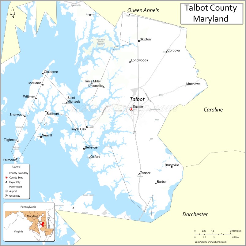
Map of Talbot County, Maryland
About St. Mary's County Map, Alabama: The map showing the county boundary, county seat, major cities, highways, water bodies and neighbouring counties.
More Maryland Maps & Info
Map of Talbot County, Maryland
Talbot County is a county located in the U.S. state of Maryland. It's county seat is Easton. As per 2020 census, the population of Talbot County is 37626 people and population density is square miles. According to the United States Census Bureau, the county has a total area of 477 sq mi (1,235 km2). Talbot County was established on 1662.
Talbot County Facts
| County Info | Facts |
|---|---|
| County | St. Mary's County |
| County Seat | Leonardtown |
| State | Maryland |
| Country | United States |
| FIPS code | 37 |
| Established | 1637 |
| Area | 611 sq mi (1,582 km2) |
| Population | 114468 |
| Density | |
| Formed / Origin | From unorganized territory. Was named Potomac County between 1654 and 1658. |
Ctities in Talbot county
| City Name | Type | Population (2020) | Pop. Density | Area |
|---|---|---|---|---|
| Queen Anne | Town | 192 | 1,476.9/sq mi (570.2/km2) | 0.13 sq mi (0.34 km2) |
| Easton | Town | 17,101 | 1,619.4/sq mi (625.3/km2) | 10.56 sq mi (27.4 km2) |
| Oxford | Town | 611 | 1,131.5/sq mi (436.9/km2) | 0.54 sq mi (1.4 km2) |
| St. Michaels | Town | 1,049 | 912.2/sq mi (352.2/km2) | 1.15 sq mi (3 km2) |
| Trappe | Town | 1,177 | 423.4/sq mi (163.5/km2) | 2.78 sq mi (7.2 km2) |
- Allegany County Map
- Anne Arundel County Map
- Baltimore County Map
- Calvert County Map
- Caroline County Map
- Carroll County Map
- Cecil County Map
- Charles County Map
- Dorchester County Map
- Frederick County Map
- Garrett County Map
- Harford County Map
- Howard County Map
- Kent County Map
- Montgomery County Map
- Prince George's County Map
- Queen Anne's County Map
- St Mary's County Map
- Somerset County Map
- Talbot County Map
- Washington County Map
- Wicomico County Map
- Worcester County Map
- Baltimore City County Map
- Alabama Counties
- Alaska boroughs
- Arizona Counties
- Arkansas Counties
- California County Map
- Colorado Counties
- Connecticut Counties
- Delaware Counties
- Florida County Map
- Georgia County Map
- Hawaii Counties
- Idaho Counties
- Illinois Counties
- Indiana Counties
- Iowa Counties
- Kansas Counties
- Kentucky Counties
- Louisiana Counties
- Maine Counties
- Maryland Counties
- Massachusetts Counties
- Michigan County Map
- Minnesota Counties
- Mississippi Counties
- Missouri Counties
- Montana Counties
- Nebraska Counties
- New Hampshire Counties
- New Jersey Counties
- New Mexico Counties
- North Carolina Counties
- North Dakota Counties
- Oklahoma Counties
- Oregon Counties
- Pennsylvania Counties
- Rhode Island Counties
- South Carolina Counties
- South Dakota Counties
- Map of Tennessee
- Texas County Map
- Utah Counties
- Vermont Counties
- Virginia Counties
- Washington Counties
- West Virginia Counties
- Wisconsin Counties
- Wyoming Counties
- Nevada Counties
- New York Counties
- Ohio County Map