
Written and Fact-checked by Whereig Editors, Reviewed by Mukesh Kumar| Last Updated On: May 11, 2026
Map of Charles County - Charles County is a county located in the U.S. state of Maryland. Charles County Map showing cities, highways, important places and water bodies. Get Where is Charles County located in the map, major cities in Charles county, population, areas, and places of interest.
Map of Dorchester County, Maryland
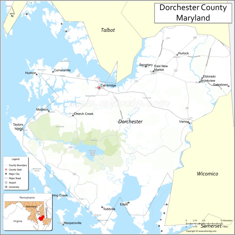
About Charles County Map, Alabama: The map showing the county boundary, county seat, major cities, highways, water bodies and neighbouring counties.
More Maryland Maps & Info
Map of Dorchester County, Maryland
Dorchester County is a county located in the U.S. state of Maryland. It's county seat is Cambridge. As per 2020 census, the population of Dorchester County is 32489 people and population density is square miles. According to the United States Census Bureau, the county has a total area of 540 sq mi (1,399 km2). Dorchester County was established on 1668.
Dorchester County Facts
| Continent | North America |
| Country | United States |
| State | Maryland |
| County Seat | Cambridge |
| Largest City/Town | Cambridge |
| Established | 1669 |
| Total Area | 983 sq mi (2,546 sq km) |
| Land Area | 557 sq mi (1,443 sq km) |
| Water Area | 426 sq mi (1,103 sq km) |
| Population | 32,531 (Census 2020) |
| Population Density | 58.4 people per sq mi |
| Time Zone | Eastern Time Zone (ET) |
| Major Highways | U.S. Route 50, Maryland Route 16, Maryland Route 331, Maryland Route 343 |
| Major Rivers | Choptank River, Nanticoke River, Chesapeake Bay |
| Neighboring Counties | Talbot County, Caroline County, Wicomico County, Somerset County |
| Famous For | Chesapeake Bay marshlands, Harriet Tubman history, seafood, wildlife refuges, waterfront towns |
| Top Attractions | Blackwater National Wildlife Refuge, Harriet Tubman Underground Railroad Visitor Center, Cambridge waterfront, Chesapeake Bay recreation, Blackwater paddling trails |
| Official Website | Official Website |
About Dorchester County, Maryland
Dorchester County is located on Maryland’s Eastern Shore in the United States along the Chesapeake Bay and was established in 1669. The county seat and largest city is Cambridge. The county is known for expansive wetlands, wildlife refuges, seafood harvesting, Harriet Tubman heritage, boating, and scenic Chesapeake Bay landscapes.
Cities and Towns in Dorchester County, Maryland
| City/Town | Population (Census 2020) | Latitude & Longitude |
|---|---|---|
| Cambridge (county seat) | 13,096 | 38.5632°N, 76.0788°W |
| Hurlock | 2,124 | 38.6240°N, 75.8624°W |
| East New Market | 404 | 38.5987°N, 75.9241°W |
| Secretary | 562 | 38.5235°N, 75.9499°W |
| Vienna | 271 | 38.4843°N, 75.8285°W |
| Brookview | 60 | 38.5782°N, 75.9430°W |
| Eldorado | 45 | 38.5826°N, 75.7894°W |
| Galestown | 114 | 38.4490°N, 75.7127°W |
| Church Creek | 102 | 38.4479°N, 76.0704°W |
| Fishing Creek | 163 | 38.2910°N, 76.2107°W |
Golf Courses in Dorchester County, Maryland
| Golf Course | Location | Latitude & Longitude |
|---|---|---|
| River Marsh Golf Club | Cambridge | 38.5544°N, 76.0418°W |
| Cambridge Country Club | Cambridge | 38.5752°N, 76.0921°W |
| Blackwater Golf Area | Near Church Creek | 38.4487°N, 76.0828°W |
Roads and Highways in Dorchester County
Major highways connect the county with Maryland’s Eastern Shore, Chesapeake Bay communities, and coastal regions.
- U.S. Route 50 - primary east-west highway through Cambridge linking Annapolis and Ocean City
- Maryland Route 16 - regional route through agricultural and wetland communities
- Maryland Route 331 - scenic highway crossing rivers and marshland areas
- Maryland Route 343 - local route serving waterfront and fishing communities
- Maryland Route 335 - connector route through Blackwater refuge regions
Neighboring Counties of Dorchester County
- Talbot County (northwest)
- Caroline County (north)
- Wicomico County (east)
- Somerset County (south)
Top Attractions in Dorchester County, Maryland
The county offers wildlife viewing, Chesapeake Bay recreation, and important historical landmarks.
- Blackwater National Wildlife Refuge - major birdwatching destination with wetlands and wildlife habitats
- Harriet Tubman Underground Railroad Visitor Center - exhibits honoring Harriet Tubman and freedom trails
- Cambridge Waterfront - marina, restaurants, parks, and Chesapeake Bay scenery
- Blackwater Paddling Trails - kayaking and canoeing through marshlands and tidal waterways
- Choptank River Lighthouse - replica lighthouse and maritime history attraction
- Historic Downtown Cambridge - museums, galleries, and preserved historic architecture
- Fishing and Crabbing Areas - seafood and recreational fishing throughout the Chesapeake region
- Harriet Tubman Scenic Byway - driving route highlighting historic and cultural landmarks
- Nature Trails and Wetland Areas - hiking and photography opportunities in marsh ecosystems
- Waterfront Seafood Restaurants - local cuisine featuring Maryland blue crabs and oysters
Distance from Dorchester County to Nearby Cities
The following distances are measured by road (driving).
- Cambridge to Annapolis (Anne Arundel County), Maryland - 58 mi (93 km)
- Cambridge to Baltimore (Baltimore City), Maryland - 87 mi (140 km)
- Cambridge to Washington, D.C. - 92 mi (148 km)
- Cambridge to Salisbury (Wicomico County), Maryland - 46 mi (74 km)
- Cambridge to Ocean City (Worcester County), Maryland - 78 mi (126 km)
- Cambridge to Dover (Kent County), Delaware - 63 mi (101 km)
- Cambridge to Wilmington (New Castle County), Delaware - 112 mi (180 km)
- Cambridge to Philadelphia (Philadelphia County), Pennsylvania - 154 mi (248 km)
- Cambridge to Richmond (Richmond City), Virginia - 184 mi (296 km)
- Cambridge to Norfolk (Norfolk City), Virginia - 186 mi (299 km)
- Cambridge to New York City (New York County), New York - 248 mi (399 km)
- Cambridge to Pittsburgh (Allegheny County), Pennsylvania - 337 mi (542 km)
FAQs about Dorchester County
Dorchester County is located on Maryland’s Eastern Shore along the Chesapeake Bay.
Dorchester County has a population of 32,531 according to the Census 2020.
The county is known for wetlands, wildlife refuges, Harriet Tubman history, seafood, and Chesapeake Bay recreation.
Major highways include U.S. Route 50, Maryland Route 16, Maryland Route 331, and Maryland Route 343.
Yes, Dorchester County has golf facilities including River Marsh Golf Club and Cambridge Country Club.
References
- QuickFacts - U.S. Census Bureau
- United States Census Bureau
- United States Geological Survey (USGS)
- National Geodetic Survey
- Official Website
- Allegany County Map
- Anne Arundel County Map
- Baltimore County Map
- Calvert County Map
- Caroline County Map
- Carroll County Map
- Cecil County Map
- Charles County Map
- Dorchester County Map
- Frederick County Map
- Garrett County Map
- Harford County Map
- Howard County Map
- Kent County Map
- Montgomery County Map
- Prince George's County Map
- Queen Anne's County Map
- St Mary's County Map
- Somerset County Map
- Talbot County Map
- Washington County Map
- Wicomico County Map
- Worcester County Map
- Baltimore City County Map
- Alabama Counties
- Alaska boroughs
- Arizona Counties
- Arkansas Counties
- California County Map
- Colorado Counties
- Connecticut Counties
- Delaware Counties
- Florida County Map
- Georgia County Map
- Hawaii Counties
- Idaho Counties
- Illinois Counties
- Indiana Counties
- Iowa Counties
- Kansas Counties
- Kentucky Counties
- Louisiana Counties
- Maine Counties
- Maryland Counties
- Massachusetts Counties
- Michigan County Map
- Minnesota Counties
- Mississippi Counties
- Missouri Counties
- Montana Counties
- Nebraska Counties
- Nevada Counties
- New York Counties
- New Hampshire Counties
- New Jersey Counties
- New Mexico Counties
- North Carolina Counties
- North Dakota Counties
- Ohio County Map
- Oklahoma Counties
- Oregon Counties
- Pennsylvania Counties
- Rhode Island Counties
- South Carolina Counties
- South Dakota Counties
- Map of Tennessee
- Texas County Map
- Utah Counties
- Vermont Counties
- Virginia Counties
- Washington Counties
- West Virginia Counties
- Wisconsin Counties
- Wyoming Counties