Written and Fact-checked by Whereig Editors, Reviewed by Mukesh Kumar| Last Updated On: May 11, 2026
Map of Harford County - Harford County is a county located in the U.S. state of Maryland. Harford County Map showing cities, highways, important places and water bodies. Get Where is Harford County located in the map, major cities in Harford county, population, areas, and places of interest.
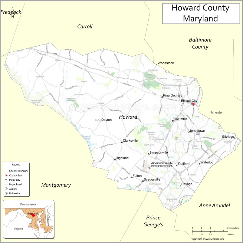
Map of Howard County, Maryland
About Harford County Map, Alabama: The map showing the county boundary, county seat, major cities, highways, water bodies and neighbouring counties.
More Maryland Maps & Info
Map of Howard County, Maryland
Howard County is a county located in the U.S. state of Maryland. It's county seat is Ellicott City. As per 2020 census, the population of Howard County is 334529 people and population density is square miles. According to the United States Census Bureau, the county has a total area of 254 sq mi (658 km2). Howard County was established on 1851.
Howard County Facts
| Continent | North America |
| Country | United States |
| State | Maryland |
| County Seat | Ellicott City |
| Largest City/Town | Columbia |
| Established | 1851 |
| Total Area | 253 sq mi (655 sq km) |
| Land Area | 251 sq mi (650 sq km) |
| Water Area | 2 sq mi (5 sq km) |
| Population | 332,317 (Census 2020) |
| Population Density | 1,324 people per sq mi |
| Time Zone | Eastern Time Zone (ET) |
| Major Highways | Interstate 95, Interstate 70, U.S. Route 29, Maryland Route 100 |
| Major Rivers | Patapsco River, Little Patuxent River, Middle Patuxent River |
| Neighboring Counties | Baltimore County, Carroll County, Frederick County, Montgomery County, Anne Arundel County, Prince George’s County |
| Famous For | Planned communities, high quality of life, education, technology sector, parks and trails |
| Top Attractions | Historic Ellicott City, Merriweather Post Pavilion, Patapsco Valley State Park, The Mall in Columbia, Blandair Regional Park |
| Official Website | Official Website |
About Howard County, Maryland
Howard County is located in central Maryland in the United States between Baltimore and Washington, D.C., and was established in 1851. The county seat is Ellicott City, while Columbia is the largest community. The county is known for planned suburban development, excellent schools, parks, cultural attractions, and a strong technology and business sector.
Cities and Communities in Howard County, Maryland
| City/Community | Population (Census 2020) | Latitude & Longitude |
|---|---|---|
| Columbia | 104,681 | 39.2037°N, 76.8610°W |
| Ellicott City (county seat) | 75,947 | 39.2673°N, 76.7983°W |
| Elkridge | 25,171 | 39.2121°N, 76.7130°W |
| North Laurel | 4,474 | 39.1284°N, 76.8441°W |
| Jessup (partly) | 10,535 | 39.1493°N, 76.7750°W |
| Savage | 7,542 | 39.1379°N, 76.8258°W |
| Clarksville | 14,951 | 39.2065°N, 76.9433°W |
| Fulton | 4,049 | 39.1501°N, 76.9236°W |
| Highland | 1,034 | 39.1812°N, 76.9669°W |
| Dayton | 1,974 | 39.2393°N, 76.9875°W |
Golf Courses in Howard County, Maryland
| Golf Course | Location | Latitude & Longitude |
|---|---|---|
| Fairway Hills Golf Club | Columbia | 39.2218°N, 76.8797°W |
| Hobbits Glen Golf Club | Columbia | 39.1950°N, 76.8774°W |
| Waverly Woods Golf Club | Marriottsville | 39.3452°N, 76.9070°W |
Roads and Highways in Howard County
Major highways connect the county with Baltimore, Washington, D.C., and surrounding Maryland communities.
- Interstate 95 - major East Coast interstate through southeastern Howard County
- Interstate 70 - east-west interstate linking Baltimore with Frederick and western Maryland
- U.S. Route 29 - important commuter highway connecting Columbia with Washington metropolitan areas
- Maryland Route 100 - connector highway linking Howard County with Anne Arundel and Baltimore counties
- Maryland Route 32 - major regional route through central Howard County
Neighboring Counties of Howard County
- Baltimore County (north)
- Carroll County (northwest)
- Frederick County (west)
- Montgomery County (southwest)
- Anne Arundel County (east)
- Prince George’s County (south)
Top Attractions in Howard County, Maryland
The county offers parks, cultural attractions, shopping, and historic communities.
- Historic Ellicott City - preserved historic district with shops, museums, and restaurants
- Merriweather Post Pavilion - major outdoor concert venue hosting national music events
- Patapsco Valley State Park - hiking, biking, fishing, and scenic river recreation
- The Mall in Columbia - regional shopping and entertainment destination
- Blandair Regional Park - sports fields, playgrounds, and recreational facilities
- Centennial Park - lakefront park with trails, boating, and picnic areas
- Robinson Nature Center - environmental education and nature exhibits
- Lake Kittamaqundi - scenic centerpiece of Columbia with walking paths and events
- Clark’s Elioak Farm - family-friendly farm attraction with petting zoo and seasonal activities
- Wine Trails and Local Breweries - regional wineries and craft beverage destinations
Distance from Howard County to Nearby Cities
The following distances are measured by road (driving).
- Ellicott City to Baltimore (Baltimore City), Maryland - 15 mi (24 km)
- Ellicott City to Annapolis (Anne Arundel County), Maryland - 28 mi (45 km)
- Ellicott City to Washington, D.C. - 32 mi (51 km)
- Ellicott City to Frederick (Frederick County), Maryland - 35 mi (56 km)
- Ellicott City to Wilmington (New Castle County), Delaware - 78 mi (126 km)
- Ellicott City to Philadelphia (Philadelphia County), Pennsylvania - 107 mi (172 km)
- Ellicott City to Richmond (Richmond City), Virginia - 143 mi (230 km)
- Ellicott City to Harrisburg (Dauphin County), Pennsylvania - 84 mi (135 km)
- Ellicott City to Norfolk (Norfolk City), Virginia - 225 mi (362 km)
- Ellicott City to New York City (New York County), New York - 195 mi (314 km)
- Ellicott City to Pittsburgh (Allegheny County), Pennsylvania - 228 mi (367 km)
- Ellicott City to Boston (Suffolk County), Massachusetts - 408 mi (657 km)
FAQs about Howard County
Howard County is located in central Maryland between Baltimore and Washington, D.C.
Howard County has a population of 332,317 according to the Census 2020.
The county is known for planned communities, excellent schools, parks, and technology businesses.
Major highways include Interstate 95, Interstate 70, U.S. Route 29, and Maryland Route 100.
Yes, Howard County has golf facilities including Fairway Hills Golf Club and Hobbits Glen Golf Club.
References
- QuickFacts - U.S. Census Bureau
- United States Census Bureau
- United States Geological Survey (USGS)
- National Geodetic Survey
- Official Website
- Allegany County Map
- Anne Arundel County Map
- Baltimore County Map
- Calvert County Map
- Caroline County Map
- Carroll County Map
- Cecil County Map
- Charles County Map
- Dorchester County Map
- Frederick County Map
- Garrett County Map
- Harford County Map
- Howard County Map
- Kent County Map
- Montgomery County Map
- Prince George's County Map
- Queen Anne's County Map
- St Mary's County Map
- Somerset County Map
- Talbot County Map
- Washington County Map
- Wicomico County Map
- Worcester County Map
- Baltimore City County Map
- Alabama Counties
- Alaska boroughs
- Arizona Counties
- Arkansas Counties
- California County Map
- Colorado Counties
- Connecticut Counties
- Delaware Counties
- Florida County Map
- Georgia County Map
- Hawaii Counties
- Idaho Counties
- Illinois Counties
- Indiana Counties
- Iowa Counties
- Kansas Counties
- Kentucky Counties
- Louisiana Counties
- Maine Counties
- Maryland Counties
- Massachusetts Counties
- Michigan County Map
- Minnesota Counties
- Mississippi Counties
- Missouri Counties
- Montana Counties
- Nebraska Counties
- Nevada Counties
- New York Counties
- New Hampshire Counties
- New Jersey Counties
- New Mexico Counties
- North Carolina Counties
- North Dakota Counties
- Ohio County Map
- Oklahoma Counties
- Oregon Counties
- Pennsylvania Counties
- Rhode Island Counties
- South Carolina Counties
- South Dakota Counties
- Map of Tennessee
- Texas County Map
- Utah Counties
- Vermont Counties
- Virginia Counties
- Washington Counties
- West Virginia Counties
- Wisconsin Counties
- Wyoming Counties