Written and Fact-checked by Whereig Editors, Reviewed by Mukesh Kumar| Last Updated On: May 11, 2026
Map of Washington County - Washington County is a county located in the U.S. state of Maryland. Washington County Map showing cities, highways, important places and water bodies. Get Where is Washington County located in the map, major cities in Washington county, population, areas, and places of interest.
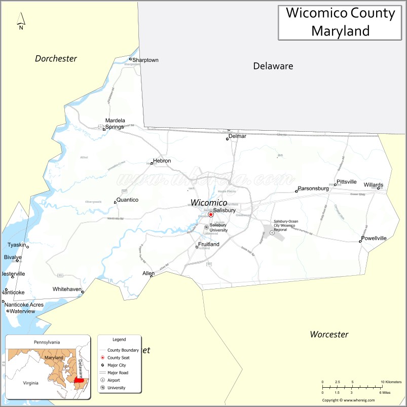
Map of Wicomico County, Maryland
About Washington County Map, Alabama: The map showing the county boundary, county seat, major cities, highways, water bodies and neighbouring counties.
More Maryland Maps & Info
Map of Wicomico County, Maryland
Wicomico County is a county located in the U.S. state of Maryland. It's county seat is Salisbury. As per 2020 census, the population of Wicomico County is 103980 people and population density is square miles. According to the United States Census Bureau, the county has a total area of 400 sq mi (1,036 km2). Wicomico County was established on 1867.
Wicomico County Facts
| Continent | North America |
| Country | United States |
| State | Maryland |
| County Seat | Salisbury |
| Largest City/Town | Salisbury |
| Established | 1867 |
| Total Area | 400 sq mi (1,036 sq km) |
| Land Area | 374 sq mi (969 sq km) |
| Water Area | 26 sq mi (67 sq km) |
| Population | 103,588 (Census 2020) |
| Population Density | 277 people per sq mi |
| Time Zone | Eastern Time Zone (ET) |
| Major Highways | U.S. Route 13, U.S. Route 50, U.S. Route 113, Maryland Route 349 |
| Major Rivers | Wicomico River, Nanticoke River, Pocomoke River |
| Neighboring Counties | Dorchester County, Somerset County, Worcester County, Sussex County (Delaware) |
| Famous For | Eastern Shore commerce, Salisbury University, poultry industry, waterfront recreation, regional transportation hub |
| Top Attractions | Salisbury Zoo, Pemberton Historical Park, Salisbury University, Poplar Hill Mansion, Wicomico River recreation |
| Official Website | Official Website |
About Wicomico County, Maryland
Wicomico County is located on Maryland’s Eastern Shore in the United States and was established in 1867. The county seat and largest city is Salisbury, which serves as the commercial and educational center of the lower Eastern Shore. The county is known for Salisbury University, agriculture and poultry production, waterfront recreation, and regional transportation connections.
Cities and Towns in Wicomico County, Maryland
| City/Town | Population (Census 2020) | Latitude & Longitude |
|---|---|---|
| Salisbury (county seat) | 33,050 | 38.3607°N, 75.5994°W |
| Fruitland | 5,534 | 38.3226°N, 75.6208°W |
| Delmar (partly) | 1,923 | 38.4559°N, 75.5777°W |
| Pittsville | 1,417 | 38.3854°N, 75.4121°W |
| Sharptown | 651 | 38.5440°N, 75.7197°W |
| Mardela Springs | 347 | 38.4593°N, 75.7555°W |
| Hebron | 1,084 | 38.4140°N, 75.6874°W |
| Willards | 958 | 38.3907°N, 75.3546°W |
| Parsonsburg | 368 | 38.3982°N, 75.4724°W |
| Nanticoke | 293 | 38.2679°N, 75.8882°W |
Golf Courses in Wicomico County, Maryland
| Golf Course | Location | Latitude & Longitude |
|---|---|---|
| Nutters Crossing Golf Club | Salisbury | 38.3848°N, 75.5554°W |
| Green Hill Country Club | Quantico | 38.3637°N, 75.7873°W |
| Elks Golf Course | Salisbury | 38.3950°N, 75.5789°W |
Roads and Highways in Wicomico County
Major highways connect the county with Delaware, Ocean City, and other Eastern Shore communities.
- U.S. Route 13 - primary north-south highway through Salisbury and the Eastern Shore
- U.S. Route 50 - major east-west route connecting Salisbury with Ocean City and Annapolis
- U.S. Route 113 - regional connector highway toward Delaware beaches and southern Maryland
- Maryland Route 349 - scenic route toward Nanticoke and waterfront communities
- Maryland Route 354 - local roadway serving agricultural and rural areas
Neighboring Counties of Wicomico County
- Dorchester County (northwest)
- Somerset County (southwest)
- Worcester County (east)
- Sussex County, Delaware (north)
Top Attractions in Wicomico County, Maryland
The county offers parks, university attractions, waterfront recreation, and Eastern Shore cultural experiences.
- Salisbury Zoo - free public zoo featuring wildlife exhibits and family attractions
- Pemberton Historical Park - trails, forests, educational programs, and historic plantation grounds
- Salisbury University - cultural events, sports, galleries, and educational attractions
- Poplar Hill Mansion - historic 19th-century home and museum in Salisbury
- Wicomico River Recreation - boating, kayaking, fishing, and waterfront parks
- Downtown Salisbury - restaurants, breweries, shops, and seasonal festivals
- Ward Museum of Wildfowl Art - exhibits dedicated to bird carving and wildlife art
- Riverwalk Games Park - outdoor recreation and community events
- Eastern Shore Baseball and Sports Facilities - regional tournaments and sporting events
- Local Seafood Restaurants - Maryland crab dishes, oysters, and Eastern Shore cuisine
Distance from Wicomico County to Nearby Cities
The following distances are measured by road (driving).
- Salisbury to Ocean City (Worcester County), Maryland - 32 mi (51 km)
- Salisbury to Dover (Kent County), Delaware - 58 mi (93 km)
- Salisbury to Annapolis (Anne Arundel County), Maryland - 88 mi (142 km)
- Salisbury to Baltimore (Baltimore City), Maryland - 116 mi (187 km)
- Salisbury to Washington, D.C. - 119 mi (191 km)
- Salisbury to Norfolk (Norfolk City), Virginia - 136 mi (219 km)
- Salisbury to Richmond (Richmond City), Virginia - 188 mi (303 km)
- Salisbury to Philadelphia (Philadelphia County), Pennsylvania - 171 mi (275 km)
- Salisbury to New York City (New York County), New York - 265 mi (426 km)
- Salisbury to Pittsburgh (Allegheny County), Pennsylvania - 354 mi (570 km)
- Salisbury to Charlotte (Mecklenburg County), North Carolina - 410 mi (660 km)
- Salisbury to Boston (Suffolk County), Massachusetts - 502 mi (808 km)
FAQs about Wicomico County
Wicomico County is located on Maryland’s Eastern Shore.
Wicomico County has a population of 103,588 according to the Census 2020.
The county is known for Salisbury University, the poultry industry, waterfront recreation, and Eastern Shore commerce.
Major highways include U.S. Route 13, U.S. Route 50, U.S. Route 113, and Maryland Route 349.
Yes, Wicomico County has golf facilities including Nutters Crossing Golf Club and Green Hill Country Club.
References
- QuickFacts - U.S. Census Bureau
- United States Census Bureau
- United States Geological Survey (USGS)
- National Geodetic Survey
- Official Website
- Allegany County Map
- Anne Arundel County Map
- Baltimore County Map
- Calvert County Map
- Caroline County Map
- Carroll County Map
- Cecil County Map
- Charles County Map
- Dorchester County Map
- Frederick County Map
- Garrett County Map
- Harford County Map
- Howard County Map
- Kent County Map
- Montgomery County Map
- Prince George's County Map
- Queen Anne's County Map
- St Mary's County Map
- Somerset County Map
- Talbot County Map
- Washington County Map
- Wicomico County Map
- Worcester County Map
- Baltimore City County Map
- Alabama Counties
- Alaska boroughs
- Arizona Counties
- Arkansas Counties
- California County Map
- Colorado Counties
- Connecticut Counties
- Delaware Counties
- Florida County Map
- Georgia County Map
- Hawaii Counties
- Idaho Counties
- Illinois Counties
- Indiana Counties
- Iowa Counties
- Kansas Counties
- Kentucky Counties
- Louisiana Counties
- Maine Counties
- Maryland Counties
- Massachusetts Counties
- Michigan County Map
- Minnesota Counties
- Mississippi Counties
- Missouri Counties
- Montana Counties
- Nebraska Counties
- Nevada Counties
- New York Counties
- New Hampshire Counties
- New Jersey Counties
- New Mexico Counties
- North Carolina Counties
- North Dakota Counties
- Ohio County Map
- Oklahoma Counties
- Oregon Counties
- Pennsylvania Counties
- Rhode Island Counties
- South Carolina Counties
- South Dakota Counties
- Map of Tennessee
- Texas County Map
- Utah Counties
- Vermont Counties
- Virginia Counties
- Washington Counties
- West Virginia Counties
- Wisconsin Counties
- Wyoming Counties