Written and Fact-checked by Whereig Editors, Reviewed by Mukesh Kumar| Last Updated On: May 11, 2026
Map of Frederick County - Frederick County is a county located in the U.S. state of Maryland. Frederick County Map showing cities, highways, important places and water bodies. Get Where is Frederick County located in the map, major cities in Frederick county, population, areas, and places of interest.
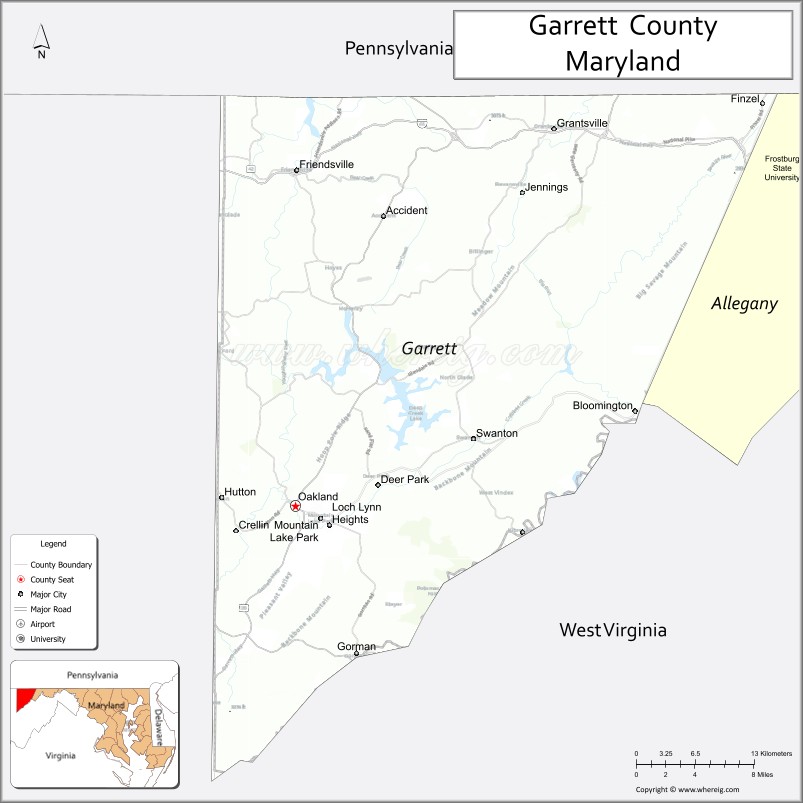
Map of Garrett County, Maryland
About Frederick County Map, Alabama: The map showing the county boundary, county seat, major cities, highways, water bodies and neighbouring counties.
More Maryland Maps & Info
Map of Garrett County, Maryland
Garrett County is a county located in the U.S. state of Maryland. It's county seat is Oakland. As per 2020 census, the population of Garrett County is 28702 people and population density is square miles. According to the United States Census Bureau, the county has a total area of 656 sq mi (1,699 km2). Garrett County was established on 1872.
Garrett County Facts
| Continent | North America |
| Country | United States |
| State | Maryland |
| County Seat | Oakland |
| Largest City/Town | Mountain Lake Park |
| Established | 1872 |
| Total Area | 656 sq mi (1,699 sq km) |
| Land Area | 648 sq mi (1,678 sq km) |
| Water Area | 8 sq mi (21 sq km) |
| Population | 28,806 (Census 2020) |
| Population Density | 44.5 people per sq mi |
| Time Zone | Eastern Time Zone (ET) |
| Major Highways | Interstate 68, U.S. Route 219, Maryland Route 42, Maryland Route 135 |
| Major Rivers | Youghiogheny River, Savage River, Potomac River headwaters |
| Neighboring Counties | Allegany County, Preston County (West Virginia), Tucker County (West Virginia), Somerset County (Pennsylvania), Fayette County (Pennsylvania) |
| Famous For | Deep Creek Lake, Appalachian Mountains, skiing, forests, hiking, outdoor recreation |
| Top Attractions | Deep Creek Lake, Wisp Resort, Swallow Falls State Park, Youghiogheny River, Herrington Manor State Park |
| Official Website | Official Website |
About Garrett County, Maryland
Garrett County is located in western Maryland in the United States within the Appalachian Mountains and was established in 1872. The county seat is Oakland, while Mountain Lake Park is the largest municipality by population. The county is known for mountain scenery, Deep Creek Lake, skiing, forests, hiking, and year-round outdoor recreation.
Cities and Towns in Garrett County, Maryland
| City/Town | Population (Census 2020) | Latitude & Longitude |
|---|---|---|
| Oakland (county seat) | 1,925 | 39.4109°N, 79.4067°W |
| Mountain Lake Park | 2,092 | 39.3987°N, 79.3817°W |
| Accident | 325 | 39.6281°N, 79.3192°W |
| Friendsville | 491 | 39.6634°N, 79.4053°W |
| Grantsville | 766 | 39.6954°N, 79.1511°W |
| Kitzmiller | 274 | 39.3940°N, 79.1847°W |
| Loch Lynn Heights | 552 | 39.3978°N, 79.3725°W |
| Deer Park | 399 | 39.4267°N, 79.3248°W |
| Bittinger | 148 | 39.5820°N, 79.2214°W |
| McHenry | 1,400+ | 39.5576°N, 79.3528°W |
Golf Courses in Garrett County, Maryland
| Golf Course | Location | Latitude & Longitude |
|---|---|---|
| Lodestone Golf Course | McHenry | 39.5438°N, 79.3642°W |
| Fantasy Valley Golf Course | McHenry | 39.5574°N, 79.3647°W |
| Oakland Golf Club | Oakland | 39.4055°N, 79.4212°W |
Roads and Highways in Garrett County
Major highways connect the county with western Maryland, Pennsylvania, and West Virginia mountain regions.
- Interstate 68 - major east-west interstate through northern Garrett County
- U.S. Route 219 - scenic north-south highway connecting Maryland with Pennsylvania and West Virginia
- Maryland Route 42 - mountain roadway serving western county communities
- Maryland Route 135 - route through Oakland and southern Garrett County
- Maryland Route 495 - regional connector through rural Appalachian landscapes
Neighboring Counties of Garrett County
- Allegany County (east)
- Preston County, West Virginia (southwest)
- Tucker County, West Virginia (south)
- Somerset County, Pennsylvania (north)
- Fayette County, Pennsylvania (northwest)
Top Attractions in Garrett County, Maryland
The county offers mountain recreation, lake activities, forests, waterfalls, and winter sports destinations.
- Deep Creek Lake - Maryland’s largest freshwater lake with boating, fishing, swimming, and waterfront recreation
- Wisp Resort - skiing, snowboarding, mountain biking, golf, and year-round outdoor activities
- Swallow Falls State Park - scenic waterfalls, hiking trails, and old-growth forest landscapes
- Youghiogheny River - whitewater rafting, kayaking, and fishing opportunities
- Herrington Manor State Park - mountain lake recreation, cabins, hiking, and camping
- Garrett State Forest - hiking, wildlife viewing, and scenic Appalachian forest landscapes
- Savage River State Forest - camping, trout fishing, and backcountry recreation
- Deep Creek Lake State Park - beaches, nature center, and outdoor recreation facilities
- Historic Oakland - museums, railroad heritage, and small-town Appalachian charm
- Casselman River Bridge State Park - historic stone bridge and riverside scenery
Distance from Garrett County to Nearby Cities
The following distances are measured by road (driving).
- Oakland to Cumberland (Allegany County), Maryland - 42 mi (68 km)
- Oakland to Morgantown (Monongalia County), West Virginia - 47 mi (76 km)
- Oakland to Pittsburgh (Allegheny County), Pennsylvania - 114 mi (183 km)
- Oakland to Frederick (Frederick County), Maryland - 143 mi (230 km)
- Oakland to Baltimore (Baltimore City), Maryland - 178 mi (286 km)
- Oakland to Washington, D.C. - 185 mi (298 km)
- Oakland to Harrisburg (Dauphin County), Pennsylvania - 169 mi (272 km)
- Oakland to Richmond (Richmond City), Virginia - 252 mi (406 km)
- Oakland to Philadelphia (Philadelphia County), Pennsylvania - 274 mi (441 km)
- Oakland to Columbus (Franklin County), Ohio - 226 mi (364 km)
- Oakland to New York City (New York County), New York - 349 mi (562 km)
- Oakland to Cleveland (Cuyahoga County), Ohio - 257 mi (414 km)
FAQs about Garrett County
Garrett County is located in western Maryland within the Appalachian Mountains.
Garrett County has a population of 28,806 according to the Census 2020.
The county is known for Deep Creek Lake, mountain scenery, skiing, hiking, and outdoor recreation.
Major highways include Interstate 68, U.S. Route 219, Maryland Route 42, and Maryland Route 135.
Yes, Garrett County has golf facilities including Lodestone Golf Course and Fantasy Valley Golf Course.
References
- QuickFacts - U.S. Census Bureau
- United States Census Bureau
- United States Geological Survey (USGS)
- National Geodetic Survey
- Official Website
- Allegany County Map
- Anne Arundel County Map
- Baltimore County Map
- Calvert County Map
- Caroline County Map
- Carroll County Map
- Cecil County Map
- Charles County Map
- Dorchester County Map
- Frederick County Map
- Garrett County Map
- Harford County Map
- Howard County Map
- Kent County Map
- Montgomery County Map
- Prince George's County Map
- Queen Anne's County Map
- St Mary's County Map
- Somerset County Map
- Talbot County Map
- Washington County Map
- Wicomico County Map
- Worcester County Map
- Baltimore City County Map
- Alabama Counties
- Alaska boroughs
- Arizona Counties
- Arkansas Counties
- California County Map
- Colorado Counties
- Connecticut Counties
- Delaware Counties
- Florida County Map
- Georgia County Map
- Hawaii Counties
- Idaho Counties
- Illinois Counties
- Indiana Counties
- Iowa Counties
- Kansas Counties
- Kentucky Counties
- Louisiana Counties
- Maine Counties
- Maryland Counties
- Massachusetts Counties
- Michigan County Map
- Minnesota Counties
- Mississippi Counties
- Missouri Counties
- Montana Counties
- Nebraska Counties
- Nevada Counties
- New York Counties
- New Hampshire Counties
- New Jersey Counties
- New Mexico Counties
- North Carolina Counties
- North Dakota Counties
- Ohio County Map
- Oklahoma Counties
- Oregon Counties
- Pennsylvania Counties
- Rhode Island Counties
- South Carolina Counties
- South Dakota Counties
- Map of Tennessee
- Texas County Map
- Utah Counties
- Vermont Counties
- Virginia Counties
- Washington Counties
- West Virginia Counties
- Wisconsin Counties
- Wyoming Counties