Written and Fact-checked by Whereig Editors, Reviewed by Mukesh Kumar| Last Updated On: May 11, 2026
Map of Wicomico County - Wicomico County is a county located in the U.S. state of Maryland. Wicomico County Map showing cities, highways, important places and water bodies. Get Where is Wicomico County located in the map, major cities in Wicomico county, population, areas, and places of interest.
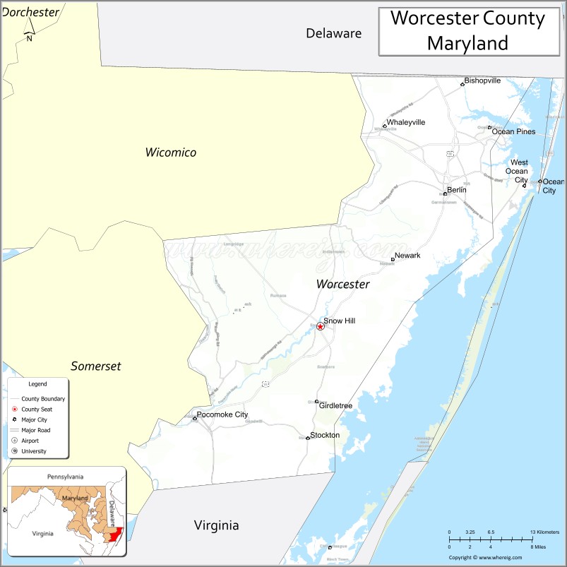
Map of Worcester County, Maryland
About Wicomico County Map, Alabama: The map showing the county boundary, county seat, major cities, highways, water bodies and neighbouring counties.
More Maryland Maps & Info
Map of Worcester County, Maryland
Worcester County is a county located in the U.S. state of Maryland. It's county seat is Snow Hill. As per 2020 census, the population of Worcester County is 53132 people and population density is square miles. According to the United States Census Bureau, the county has a total area of 695 sq mi (1,800 km2). Worcester County was established on 1742.
Worcester County Facts
| Continent | North America |
| Country | United States |
| State | Maryland |
| County Seat | Snow Hill |
| Largest City/Town | Ocean Pines |
| Established | 1742 |
| Total Area | 695 sq mi (1,800 sq km) |
| Land Area | 469 sq mi (1,215 sq km) |
| Water Area | 226 sq mi (585 sq km) |
| Population | 52,460 (Census 2020) |
| Population Density | 112 people per sq mi |
| Time Zone | Eastern Time Zone (ET) |
| Major Highways | U.S. Route 50, U.S. Route 113, Maryland Route 90, Maryland Route 611 |
| Major Rivers | Pocomoke River, Sinepuxent Bay, Isle of Wight Bay, Atlantic Ocean |
| Neighboring Counties | Wicomico County, Somerset County, Sussex County (Delaware), Accomack County (Virginia) |
| Famous For | Ocean City beaches, Atlantic coastal tourism, Assateague Island, boating, seafood, vacation resorts |
| Top Attractions | Ocean City Boardwalk, Assateague Island National Seashore, Frontier Town, Ocean Downs Casino, Pocomoke State Forest |
| Official Website | Official Website |
About Worcester County, Maryland
Worcester County is located on Maryland’s Eastern Shore in the United States along the Atlantic Ocean and was established in 1742. The county seat is Snow Hill, while Ocean Pines is the largest community by population. The county is known for Ocean City tourism, Atlantic beaches, Assateague Island wild horses, seafood, boating, and coastal recreation.
Cities and Towns in Worcester County, Maryland
| City/Town | Population (Census 2020) | Latitude & Longitude |
|---|---|---|
| Snow Hill (county seat) | 2,103 | 38.1771°N, 75.3924°W |
| Ocean Pines | 12,430 | 38.3951°N, 75.1607°W |
| Ocean City | 6,844 | 38.3365°N, 75.0849°W |
| Berlin | 5,026 | 38.3226°N, 75.2177°W |
| Pocomoke City | 4,295 | 38.0757°N, 75.5677°W |
| Newark | 365 | 38.2501°N, 75.2949°W |
| Whaleyville | 149 | 38.3946°N, 75.3093°W |
| Bishopville | 531 | 38.4251°N, 75.1935°W |
| Stockton | 82 | 38.0518°N, 75.4088°W |
| Girdletree | 173 | 38.0868°N, 75.3882°W |
Golf Courses in Worcester County, Maryland
| Golf Course | Location | Latitude & Longitude |
|---|---|---|
| Ocean City Golf Club | Berlin | 38.3520°N, 75.1835°W |
| Eagle's Landing Golf Course | Berlin | 38.2825°N, 75.1594°W |
| GlenRiddle Golf Club | Berlin | 38.3187°N, 75.1975°W |
Roads and Highways in Worcester County
Major highways connect the county with Ocean City, Delaware beaches, and Maryland’s Eastern Shore.
- U.S. Route 50 - major east-west highway leading to Ocean City
- U.S. Route 113 - primary north-south route through inland Worcester County
- Maryland Route 90 - expressway connecting inland highways with Ocean City
- Maryland Route 611 - coastal roadway serving Assateague Island and resort areas
- Maryland Route 376 - scenic connector through rural and coastal communities
Neighboring Counties of Worcester County
- Wicomico County (west)
- Somerset County (southwest)
- Sussex County, Delaware (north)
- Accomack County, Virginia (south)
Top Attractions in Worcester County, Maryland
The county offers Atlantic beaches, coastal recreation, wildlife preserves, and vacation resort attractions.
- Ocean City Boardwalk - famous beachfront promenade with shops, rides, restaurants, and entertainment
- Assateague Island National Seashore - wild horses, beaches, camping, and wildlife viewing
- Frontier Town - western-themed amusement park and campground near Berlin
- Ocean Downs Casino - gaming, horse racing, and entertainment venue
- Pocomoke State Forest - hiking, camping, canoeing, and scenic cypress swamp areas
- Historic Berlin - charming downtown with boutiques, restaurants, and historic architecture
- Northside Park - sports fields, walking trails, and waterfront recreation in Ocean City
- Fishing and Boating Areas - charter fishing, marinas, and Atlantic coastal recreation
- Assawoman Bay and Isle of Wight Bay - kayaking, paddleboarding, and boating activities
- Seafood Restaurants and Crab Houses - Maryland crab dishes, oysters, and fresh Atlantic seafood
Distance from Worcester County to Nearby Cities
The following distances are measured by road (driving).
- Snow Hill to Ocean City, Maryland - 31 mi (50 km)
- Snow Hill to Salisbury (Wicomico County), Maryland - 28 mi (45 km)
- Snow Hill to Dover (Kent County), Delaware - 79 mi (127 km)
- Snow Hill to Annapolis (Anne Arundel County), Maryland - 117 mi (188 km)
- Snow Hill to Baltimore (Baltimore City), Maryland - 145 mi (233 km)
- Snow Hill to Washington, D.C. - 149 mi (240 km)
- Snow Hill to Norfolk (Norfolk City), Virginia - 124 mi (200 km)
- Snow Hill to Richmond (Richmond City), Virginia - 176 mi (283 km)
- Snow Hill to Philadelphia (Philadelphia County), Pennsylvania - 200 mi (322 km)
- Snow Hill to New York City (New York County), New York - 294 mi (473 km)
- Snow Hill to Pittsburgh (Allegheny County), Pennsylvania - 383 mi (616 km)
- Snow Hill to Boston (Suffolk County), Massachusetts - 531 mi (855 km)
FAQs about Worcester County
Worcester County is located on Maryland’s Eastern Shore along the Atlantic Ocean.
Worcester County has a population of 52,460 according to the Census 2020.
The county is known for Ocean City beaches, Assateague Island, tourism, seafood, and coastal recreation.
Major highways include U.S. Route 50, U.S. Route 113, Maryland Route 90, and Maryland Route 611.
Yes, Worcester County has golf facilities including Ocean City Golf Club and GlenRiddle Golf Club.
References
- QuickFacts - U.S. Census Bureau
- United States Census Bureau
- United States Geological Survey (USGS)
- National Geodetic Survey
- Official Website
- Allegany County Map
- Anne Arundel County Map
- Baltimore County Map
- Calvert County Map
- Caroline County Map
- Carroll County Map
- Cecil County Map
- Charles County Map
- Dorchester County Map
- Frederick County Map
- Garrett County Map
- Harford County Map
- Howard County Map
- Kent County Map
- Montgomery County Map
- Prince George's County Map
- Queen Anne's County Map
- St Mary's County Map
- Somerset County Map
- Talbot County Map
- Washington County Map
- Wicomico County Map
- Worcester County Map
- Baltimore City County Map
- Alabama Counties
- Alaska boroughs
- Arizona Counties
- Arkansas Counties
- California County Map
- Colorado Counties
- Connecticut Counties
- Delaware Counties
- Florida County Map
- Georgia County Map
- Hawaii Counties
- Idaho Counties
- Illinois Counties
- Indiana Counties
- Iowa Counties
- Kansas Counties
- Kentucky Counties
- Louisiana Counties
- Maine Counties
- Maryland Counties
- Massachusetts Counties
- Michigan County Map
- Minnesota Counties
- Mississippi Counties
- Missouri Counties
- Montana Counties
- Nebraska Counties
- Nevada Counties
- New York Counties
- New Hampshire Counties
- New Jersey Counties
- New Mexico Counties
- North Carolina Counties
- North Dakota Counties
- Ohio County Map
- Oklahoma Counties
- Oregon Counties
- Pennsylvania Counties
- Rhode Island Counties
- South Carolina Counties
- South Dakota Counties
- Map of Tennessee
- Texas County Map
- Utah Counties
- Vermont Counties
- Virginia Counties
- Washington Counties
- West Virginia Counties
- Wisconsin Counties
- Wyoming Counties