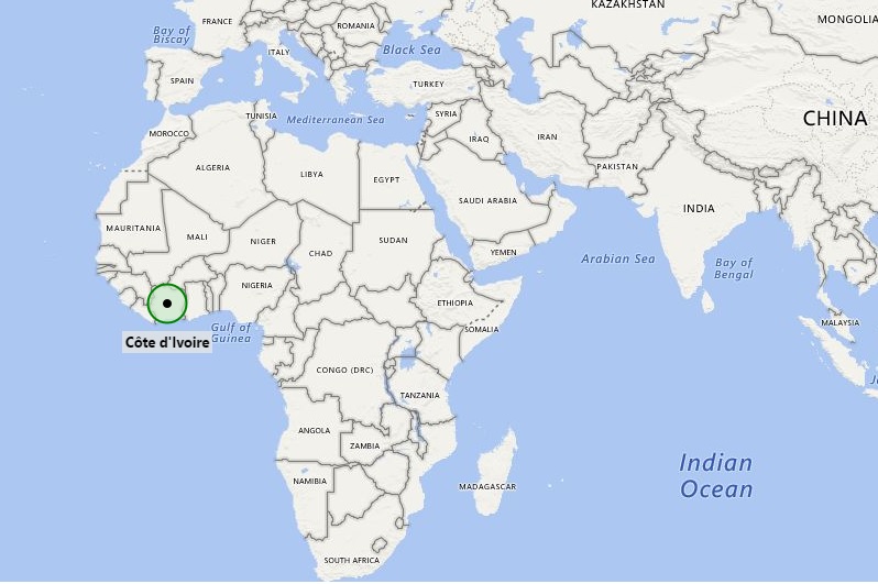
As shown on the Cote d'Ivoire location map that Côte d'Ivoire is located in the western part of Africa continent. Cote d'Ivoire map also shows that it shares its international boundaries with Ghana in the east, Burkina Faso in the north-east, Mali in the north, Guinea and Liberia in the west. However, country has also small coastline with Gulf of Guinea in the Atlantic Ocean.
Cote d'Ivoire was a French colony and only in the year 1960 it became independent. However, from 1960 to 1993, Cote d'Ivoire was led by Félix Houphouet-Boigny that has close political and economic association with West African neighbors and also with France. However, after the civil war, collapsed the earlier system; at present, the government type of Cote d'Ivoire is a republic, in which president has strong executive power. The capital city of country is Yamoussoukro but the largest city is the port city Abidjan.
The official language of the country is French, nevertheless, there are several local languages used by the native people. For example Baoule, Anyin, Dioula, Dan, and Cebaara Senufo.
Largely, the countrys economy is depends upon production and the export of coffee and cocoa. Hence, country has agriculture economy.
| Country | Cote Dlvorie |
| Continent | Africa |
| Where is Located | Ivory Coast is a country located in the West Africa |
| Coordinates | 8.0000° N, 6.0000° W |
| Capital | Yamoussoukro |
| Largest City | Abidjan |
| Neighboring Countries | Burkina Faso, Ghana, Guinea, Liberia, Mali |
| Administrative divisions | 19 regions |
| Area | 124,502 Sq mi (322,463 Sq Km) |
| Population | 20,617,068 (2009 Est.) |
| Official Language | French |
| Currency | West African CFA franc (XOF) |
| ISO Alpha-2 Code | CI |
| ISO Alpha-3 Code | CIV |
| ISO Numeric Code | 384 |
| GDP | $36.068 billion (2011 Est.) |
| Calling code | 225 |
| Time Zone | (UTC+00:00) |
| Internet TLD | .ci |
- Where is Algeria
- Where is Angola
- Where is Benin
- Where is Botswana
- Where is Burkina Faso
- Where is Burundi
- Where is Cameroon
- Where is Canary Islands
- Where is Cape Verde
- Central African Republic
- Where is Ceuta
- Where is Chad
- Where is Cote d'Ivoire
- Where is Congo
- Where is Djibouti
- Where is Egypt
- Equatorial Guinea
- Where is Eritrea
- Where is Ethiopia
- Where is Gabon
- Where is Gambia
- Where is Ghana
- Where is Guinea
- Guinea Bissau
- Where is Kenya
- Where is Lesotho
- Where is Liberia
- Where is Libya
- Where is Madagascar
- Where is Madeira
- Where is Malawi
- Where is Mali
- Where is Mauritania
- Where is Mauritius
- Where is Mayotte
- Where is Morocco
- Where is Mozambique
- Where is Namibia
- Where is Niger
- Where is Nigeria
- Where is Congo
- Where is Reunion
- Where is Rwanda
- Where is Saint Helena
- Where is Sao Tome
- Where is Senegal
- Where is Seychelles
- Where is Sierra Leone
- Where is South Africa
- Where is Sudan
- Where is Swaziland
- Where is Tanzania
- Where is Togo
- Where is Tunisia
- Where is Uganda
- Where is Western Sahara
- Where is Zambia
- Where is Zimbabwe


