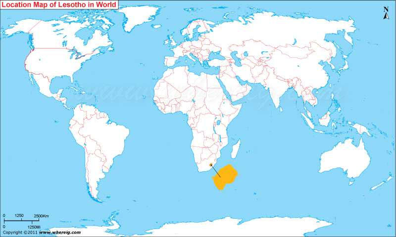
Where is Lesotho located on the world map? The given Lesotho location map shows that Lesotho located in the southern part of Africa continent.
Lesotho map also shows that the small country is entirely surrounded by the Republic of South Africa. Maseru is the capital and largest city of the country. Interestingly, the word "Lesotho" interpreted as "the land of the people who speak Sesotho."
The Government type of Lesotho is a parliamentary or constitutional monarchy where the Prime Minister is used to be the head of the government and exercises the executive power. On the contrary, the king serves a ceremonial function merely. Lesotho is a member of the Commonwealth of Nations.
Economy of the country largely depends upon diamonds exported all over the world. Besides, it also sells water to South Africa, manufacturing, agriculture, livestock etc.
| Country | Lesotho |
| Continent | Africa |
| Where is Located | Lesotho is a country located in the Southern Africa |
| Coordinates | 29.5495° S, 27.9333° E |
| Capital | Maseru |
| Largest City | Maseru |
| Neighboring Countries | South Africa |
| Administrative divisions | 10 districts |
| Area | 30,355 sq km |
| Population | 2067000 ,2009 estimate |
| Official Language | English, Sotho language |
| Currency | Lesotho loti |
| ISO Alpha-2 Code | LS |
| ISO Alpha-3 Code | LSO |
| ISO Numeric Code | 426 |
| GDP | $4.277 billion 2013 estimate |
| Calling code | 266 |
| Time Zone | SAST (UTC+2) |
| Internet TLD | .ls |
- Where is Algeria
- Where is Angola
- Where is Benin
- Where is Botswana
- Where is Burkina Faso
- Where is Burundi
- Where is Cameroon
- Where is Canary Islands
- Where is Cape Verde
- Central African Republic
- Where is Ceuta
- Where is Chad
- Where is Cote d'Ivoire
- Where is Congo
- Where is Djibouti
- Where is Egypt
- Equatorial Guinea
- Where is Eritrea
- Where is Ethiopia
- Where is Gabon
- Where is Gambia
- Where is Ghana
- Where is Guinea
- Guinea Bissau
- Where is Kenya
- Where is Lesotho
- Where is Liberia
- Where is Libya
- Where is Madagascar
- Where is Madeira
- Where is Malawi
- Where is Mali
- Where is Mauritania
- Where is Mauritius
- Where is Mayotte
- Where is Morocco
- Where is Mozambique
- Where is Namibia
- Where is Niger
- Where is Nigeria
- Where is Congo
- Where is Reunion
- Where is Rwanda
- Where is Saint Helena
- Where is Sao Tome
- Where is Senegal
- Where is Seychelles
- Where is Sierra Leone
- Where is South Africa
- Where is Sudan
- Where is Swaziland
- Where is Tanzania
- Where is Togo
- Where is Tunisia
- Where is Uganda
- Where is Western Sahara
- Where is Zambia
- Where is Zimbabwe


