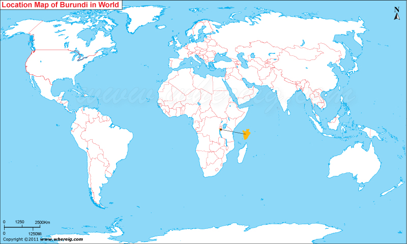
The given Burundi location map shows that Burundi is located in the Eastern part of Africa nearby Great Lakes region.
Burundi is small landlocked country that shares its international boundaries with Rwanda in the north, Tanzania in the east and south, and in the west Democratic Republic of Congo.
The chief ethnic groups of the country are the Twa, Tutsi, and Hutu. Tutsi had ruled the country over two hundred years. After this European countries occupied the region. At present, the government type of Burundi is a presidential representative democratic republic.
About sixty-two percent people of Burundi are Roman Catholic, about ten percent are Muslims, and the rest people have indigenous beliefs and Christians.
As per the report, Burundi is one of the ten poorest countries of the world. Besides, it has the lowest per capita GDP. However, as natural resource, Cobalt and copper are two important reserves in Burundi. The main exports of Burundi's main exports are coffee and sugar.
| Country | Burundi |
| Continent | Africa |
| Where is Located | Burundi is a country located in the Eastern Africa, African Great Lakes |
| Coordinates | 3°30'S30°00'E |
| Capital | Bujumbura |
| Largest City | Bujumbura |
| Neighboring Countries | DR Congo, Rwanda, Tanzania |
| Administrative divisions | 17 provinces |
| Area | 10,745 sq mi |
| Population | 10,888,321 (July 2013 est.) |
| Official Language | Kirundi and French |
| Currency | Burundi Franc |
| ISO Alpha-2 Code | BI |
| ISO Alpha-3 Code | BDI |
| ISO Numeric Code | 108 |
| GDP | $5.488 billion 2012 estimate |
| Calling code | 257 |
| Time Zone | CAT (UTC+2) |
| Internet TLD | .bi |
- Where is Algeria
- Where is Angola
- Where is Benin
- Where is Botswana
- Where is Burkina Faso
- Where is Burundi
- Where is Cameroon
- Where is Canary Islands
- Where is Cape Verde
- Central African Republic
- Where is Ceuta
- Where is Chad
- Where is Cote d'Ivoire
- Where is Congo
- Where is Djibouti
- Where is Egypt
- Equatorial Guinea
- Where is Eritrea
- Where is Ethiopia
- Where is Gabon
- Where is Gambia
- Where is Ghana
- Where is Guinea
- Guinea Bissau
- Where is Kenya
- Where is Lesotho
- Where is Liberia
- Where is Libya
- Where is Madagascar
- Where is Madeira
- Where is Malawi
- Where is Mali
- Where is Mauritania
- Where is Mauritius
- Where is Mayotte
- Where is Morocco
- Where is Mozambique
- Where is Namibia
- Where is Niger
- Where is Nigeria
- Where is Congo
- Where is Reunion
- Where is Rwanda
- Where is Saint Helena
- Where is Sao Tome
- Where is Senegal
- Where is Seychelles
- Where is Sierra Leone
- Where is South Africa
- Where is Sudan
- Where is Swaziland
- Where is Tanzania
- Where is Togo
- Where is Tunisia
- Where is Uganda
- Where is Western Sahara
- Where is Zambia
- Where is Zimbabwe


