
Written and Fact-checked by Mukesh Kumar | Last Updated On: June 15, 2026
The given Senegal location map shows that Senegal is located in the western part of the African continent. The map also shows that Senegal shares international borders with Mauritania to the north, Mali to the east, and Guinea and Guinea-Bissau to the south. The Atlantic Ocean lies along the country's western coast.
Location Map of Senegal
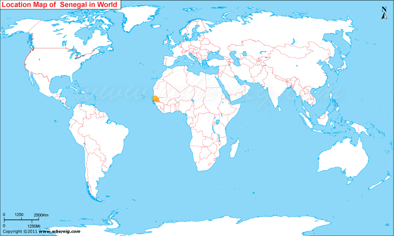
About Map: The map shows the location of Senegal in West Africa and its position on the world map.
Where is Senegal Located?
Senegal, officially the Republic of Senegal, is a country in western most part on the African continent, on the Atlantic Ocean coastline. Senegal is bordered by Atlantic Ocean and surrounded by five other countries in Africa; Mauritania, Mali, Guinea, Gambia and Guinea-Bissau. Dakar is the capital and largest city of Senegal. Dakar is one of the chief seaports on the western African coast and has historically served as the gateway to West Africa.
Senegal is bordered by Mauritania to the north, Mali to the east, Guinea to the southeast and Guinea-Bissau to the southwest.Interestingly, the name of Senegal possibly derived from the name of Senegal River, which originates from the Fauta Djallon in Guinea and then by flowing it makes boundary from the east and north side of Senegal. The capital city of Senegal is Dakar; it is located at the Cap-Vert peninsula, westernmost tip of the country. The government type of Senegal is a republic featured with multi-party system. However, the head of state is President elected for five years term. The economy of the country is largely depends upon some of the important sectors including food processing, mining, artificial fertilizer, chemicals, cement, textiles, refining imported petroleum, fishing, and tourism. Moreover, the climate of Senegal is tropical featured with two seasons i.e. the dry season and the rainy season.
Senegal Facts
| Continent | Africa |
| Country | Senegal |
| Capital | Dakar |
| Largest City | Dakar |
| Coordinates | 14.4974° N, 14.4524° W |
| Administrative Divisions | 14 Regions |
| Official Language | French |
| Demonym | Senegalese |
| Government | Presidential Republic |
| Independence | 1960 |
| Total Area | 196,722 sq km (75,955 sq mi) |
| Population | 19,000,000+ (2025 est.) |
| Population Density | 97 people per sq km |
| Currency | West African CFA Franc (XOF) |
| Country Calling Code | +221 |
| Time Zone | GMT (UTC+0) |
| Internet TLD | .sn |
| ISO Country Code | SN |
| Driving Side | Right |
| Major Cities | Dakar, Touba, Thiès, Kaolack, Saint-Louis |
| Major Airports | Blaise Diagne International Airport |
| Highest Point | Nepen Diakha (648 m) |
| Longest River | Senegal River |
| Climate | Tropical Savanna Climate |
| Average Temperature | 22°C to 35°C |
| Famous For | Gorée Island, Music, Wildlife, Beaches, Senegal River |
| National Animal | African Lion |
| National Sport | Football |
| National Dish | Thieboudienne |
| Official Website | presidence.sn |
Regions of Senegal
| Region | Capital | Population | Area | Latitude and Longitude |
|---|---|---|---|---|
| Dakar | Dakar | 4,000,000+ | 547 sq km (211 sq mi) | 14.7167° N, 17.4677° W |
| Thiès | Thiès | 2,300,000+ | 6,601 sq km (2,548 sq mi) | 14.7886° N, 16.9260° W |
| Saint-Louis | Saint-Louis | 1,100,000+ | 19,044 sq km (7,353 sq mi) | 16.0326° N, 16.4818° W |
| Kaolack | Kaolack | 1,100,000+ | 5,357 sq km (2,068 sq mi) | 14.1510° N, 16.0726° W |
| Ziguinchor | Ziguinchor | 800,000+ | 7,339 sq km (2,834 sq mi) | 12.5681° N, 16.2733° W |
| Tambacounda | Tambacounda | 900,000+ | 42,364 sq km (16,357 sq mi) | 13.7707° N, 13.6673° W |
| Diourbel | Diourbel | 1,800,000+ | 4,769 sq km (1,841 sq mi) | 14.6561° N, 16.2345° W |
| Fatick | Fatick | 850,000+ | 7,935 sq km (3,064 sq mi) | 14.3390° N, 16.4111° W |
| Kolda | Kolda | 800,000+ | 13,721 sq km (5,298 sq mi) | 12.8939° N, 14.9419° W |
| Matam | Matam | 700,000+ | 29,616 sq km (11,435 sq mi) | 15.6559° N, 13.2554° W |
10 Largest Cities in Senegal
| City | Region | Population | Latitude and Longitude |
|---|---|---|---|
| Dakar | Dakar | 1,400,000+ | 14.7167° N, 17.4677° W |
| Pikine | Dakar | 1,200,000+ | 14.7646° N, 17.3907° W |
| Guédiawaye | Dakar | 400,000+ | 14.7761° N, 17.3956° W |
| Touba | Diourbel | 1,000,000+ | 14.8670° N, 15.8830° W |
| Thiès | Thiès | 450,000+ | 14.7886° N, 16.9260° W |
| Kaolack | Kaolack | 300,000+ | 14.1510° N, 16.0726° W |
| Saint-Louis | Saint-Louis | 250,000+ | 16.0326° N, 16.4818° W |
| Ziguinchor | Ziguinchor | 230,000+ | 12.5681° N, 16.2733° W |
| Mbour | Thiès | 250,000+ | 14.4057° N, 16.9639° W |
| Rufisque | Dakar | 220,000+ | 14.7167° N, 17.2667° W |
Top Tourist Attractions and Famous Places to Visit in Senegal
- Gorée Island - Dakar
- Lake Retba (Pink Lake) - Dakar Region
- Djoudj National Bird Sanctuary - Saint-Louis
- Niokolo-Koba National Park - Tambacounda
- African Renaissance Monument - Dakar
- Bandia Wildlife Reserve - Thiès
- Cap Skirring Beach - Ziguinchor
- IFAN Museum of African Arts - Dakar
- Fathala Wildlife Reserve - Fatick
- Saloum Delta National Park - Fatick
- Saint-Louis Historic Island - Saint-Louis
- Des Almadies Peninsula - Dakar
- Mar Lodj Island - Saloum Delta
- Our Lady of Deliverance Cathedral - Dakar
- Popenguine Nature Reserve - Thiès
- Touba Grand Mosque - Touba
Major Rivers in Senegal
- Senegal River
- Gambia River
- Casamance River
- Saloum River
- Falémé River
Neighboring Countries of Senegal
- Mauritania - North
- Mali - East
- Guinea - Southeast
- Guinea-Bissau - South
- The Gambia - Surrounded by Senegal on the North, East and South
References
- Presidency of Senegal
- National Agency of Statistics and Demography (ANSD)
- World Bank - Senegal
- United Nations World Population Prospects
- CIA World Factbook - Senegal
- Where is Algeria
- Where is Angola
- Where is Benin
- Where is Botswana
- Where is Burkina Faso
- Where is Burundi
- Where is Cameroon
- Where is Canary Islands
- Where is Cape Verde
- Central African Republic
- Where is Ceuta
- Where is Chad
- Where is Cote d'Ivoire
- Where is Congo
- Where is Djibouti
- Where is Egypt
- Equatorial Guinea
- Where is Eritrea
- Where is Ethiopia
- Where is Gabon
- Where is Gambia
- Where is Ghana
- Where is Guinea
- Guinea Bissau
- Where is Kenya
- Where is Lesotho
- Where is Liberia
- Where is Libya
- Where is Madagascar
- Where is Madeira
- Where is Malawi
- Where is Mali
- Where is Mauritania
- Where is Mauritius
- Where is Mayotte
- Where is Melilla
- Where is Morocco
- Where is Mozambique
- Where is Namibia
- Where is Niger
- Where is Nigeria
- Republic of the Congo
- Where is Reunion
- Where is Rwanda
- Where is Saint Helena
- Sao Tome and Principe
- Where is Senegal
- Where is Seychelles
- Where is Sierra Leone
- Where is South Africa
- Where is Sudan
- Where is Swaziland
- Where is Tanzania
- Where is Togo
- Where is Tunisia
- Where is Uganda
- Where is Western Sahara
- Where is Zambia
- Where is Zimbabwe