
Iran is a country located in Western Asia with a large population. It shares borders with Afghanistan, Armenia, Azerbaijan, Iraq, Pakistan, Turkmenistan, and Turkey.
Location Map of Iran
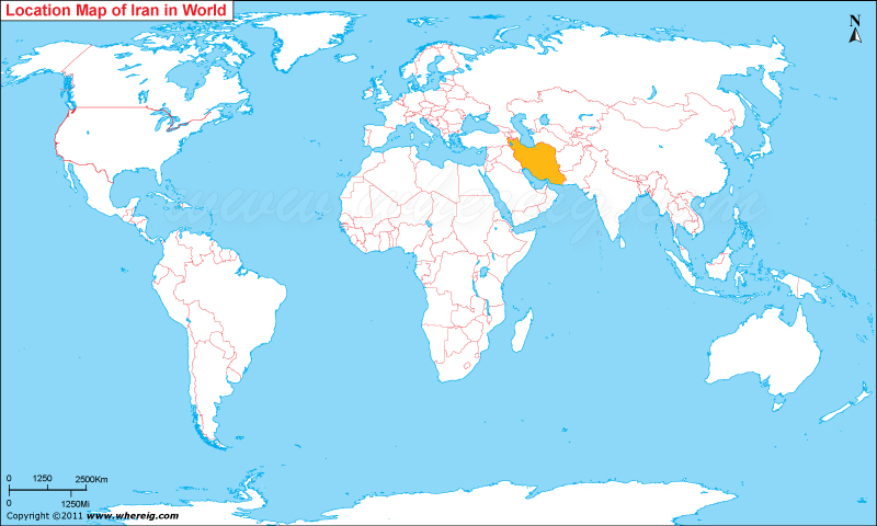
About Map: The map shows where Iran is located on the world map. Iran is in Western Asia, bordered by the Caspian Sea to the north, the Persian Gulf and the Gulf of Oman to the south, and surrounded by several neighbouring countries including Iraq, Turkey, Armenia, Azerbaijan, Turkmenistan, Afghanistan and Pakistan.
Know Where is Strait of Hormuz | Where is Tehran | Where is Kharg Island
Where is Iran Located?
As Iran location map shows that Iran is located in western Asia. Country’s name Iran is quite old and has been in use since the Sassanian era natively. However, the country was known to world by the name of Persia until 1935; but from the year 1935 the name Iran has internationally recognized. This is the reason that even in this modern era both names are used interchangeably.
Geographically, Iran is part of the Middle East and occupies a strategic position in Western Asia. As shown on the map, it shares borders with Armenia, Azerbaijan, and Turkmenistan to the north; Afghanistan and Pakistan to the east; Turkey to the northwest; and Iraq to the west. The country is bordered by the Caspian Sea to the north and the Persian Gulf to the southwest, giving it an important coastline. Due to its varied terrain, Iran’s climate ranges from arid and semi-arid to subtropical in some regions.
Iran is a founding member of many international organizations including the UN, OPEC, NAM, and OIC. Iran is always remains in news because of regional power that she holds and hence it has an important position in international energy security and world. Above all, it has huge reserves of petroleum and natural gas.
The government type of Iran is Islamic Republic and it is based upon the 1979 constitution it consists of several intricately inter-related governing bodies. However, the highest state authority is the Supreme Leader. Country’s official religion is Shia Islam and Persian is the official language.
Provinces of Iran
| Province | Capital | Population | Area | Latitude and Longitude |
|---|---|---|---|---|
| Tehran | Tehran | 14 million+ | 18,909 sq km (7,301 sq mi) | 35.6892° N, 51.3890° E |
| Isfahan | Isfahan | 5.4 million+ | 107,029 sq km (41,324 sq mi) | 32.6546° N, 51.6680° E |
| Fars | Shiraz | 5 million+ | 122,400 sq km (47,259 sq mi) | 29.5918° N, 52.5837° E |
| Khorasan Razavi | Mashhad | 6.8 million+ | 118,884 sq km (45,901 sq mi) | 36.2605° N, 59.6168° E |
| East Azerbaijan | Tabriz | 4 million+ | 45,491 sq km (17,564 sq mi) | 38.0962° N, 46.2738° E |
| Khuzestan | Ahvaz | 4.8 million+ | 64,055 sq km (24,732 sq mi) | 31.3183° N, 48.6706° E |
| Mazandaran | Sari | 3.5 million+ | 23,842 sq km (9,206 sq mi) | 36.5633° N, 53.0601° E |
| Gilan | Rasht | 2.5 million+ | 14,044 sq km (5,422 sq mi) | 37.2808° N, 49.5832° E |
| Kerman | Kerman | 3.3 million+ | 183,285 sq km (70,767 sq mi) | 30.2839° N, 57.0834° E |
| West Azerbaijan | Urmia | 3.4 million+ | 37,437 sq km (14,454 sq mi) | 37.5527° N, 45.0761° E |
10 Largest Cities in Iran
| City | Province | Population | Latitude and Longitude |
|---|---|---|---|
| Tehran | Tehran | 9 million+ | 35.6892° N, 51.3890° E |
| Mashhad | Khorasan Razavi | 3.5 million+ | 36.2605° N, 59.6168° E |
| Isfahan | Isfahan | 2.2 million+ | 32.6546° N, 51.6680° E |
| Karaj | Alborz | 2 million+ | 35.8400° N, 50.9391° E |
| Shiraz | Fars | 1.9 million+ | 29.5918° N, 52.5837° E |
| Tabriz | East Azerbaijan | 1.7 million+ | 38.0962° N, 46.2738° E |
| Qom | Qom | 1.4 million+ | 34.6416° N, 50.8746° E |
| Ahvaz | Khuzestan | 1.3 million+ | 31.3183° N, 48.6706° E |
| Kermanshah | Kermanshah | 1 million+ | 34.3142° N, 47.0650° E |
| Urmia | West Azerbaijan | 800,000+ | 37.5527° N, 45.0761° E |
Top Tourist Attractions and Famous Places to Visit in Iran
- Persepolis - Fars Province
- Naqsh-e Jahan Square - Isfahan
- Golestan Palace - Tehran
- Imam Reza Shrine - Mashhad
- Mount Damavand - Mazandaran
- Nasir al-Mulk Mosque - Shiraz
- Azadi Tower - Tehran
- Lut Desert - Kerman Province
- Tabriz Historic Bazaar Complex - Tabriz
- Ali Qapu Palace - Isfahan
- Badab-e Surt Springs - Mazandaran
- Kish Island - Hormozgan Province
- Pasargadae - Fars Province
- Rudkhan Castle - Gilan
- Hafez Tomb - Shiraz
- Lake Urmia - West Azerbaijan
Iran Facts
| Continent | Asia |
| Country | Iran |
| Official Name | Islamic Republic of Iran |
| Capital | Tehran |
| Largest City | Tehran |
| Coordinates | 32.4279° N, 53.6880° E |
| Administrative Divisions | 31 Provinces |
| Official Languages | Persian (Farsi) |
| Demonym | Iranian |
| Government | Islamic Republic |
| Independence | Established as Islamic Republic in 1979 |
| Total Area | 1,648,195 sq km (636,372 sq mi) |
| Population | 92 million+ (2025 est.) |
| Population Density | 56 people per sq km |
| Currency | Iranian Rial (IRR) |
| GDP Nominal | Approx. USD 300 billion |
| Economy | Upper-Middle Income Mixed Economy |
| Postal Code Format | ########## |
| Country Calling Code | +98 |
| Time Zone | IRST (UTC+3:30) |
| Internet TLD | .ir |
| ISO Country Code | IR |
| Driving Side | Right |
| Major Cities | Tehran, Mashhad, Isfahan, Shiraz, Tabriz |
| Major Airports | Imam Khomeini International Airport, Mehrabad Airport, Mashhad International Airport |
| Highest Point | Mount Damavand (5,610 m) |
| Longest River | Karun River |
| Climate | Arid, Semi-Arid, and Continental Climate |
| Average Summer Temperature | 25°C to 40°C |
| Average Winter Temperature | -5°C to 15°C |
| Famous For | Persian Culture, Historic Architecture, Carpets, Poetry, Oil and Gas |
| National Animal | Persian Leopard |
| National Sport | Wrestling |
| National Dish | Chelo Kebab |
| Official Website | irangov.ir |
Major Rivers in Iran
- Karun River
- Karkheh River
- Zayandeh River
- Sefid-Rud River
- Aras River
- Dez River
- Atrek River
- Harirud River
Iran Climate Facts
| Climate Type | Arid, Semi-Arid, Mediterranean, and Continental |
| Summer Temperature | 25°C to 40°C |
| Winter Temperature | -5°C to 15°C |
| Average Rainfall | 50 mm to 2,000 mm annually depending on region |
Neighboring Countries of Iran
- Iraq - West
- Turkey - Northwest
- Armenia - Northwest
- Azerbaijan - Northwest
- Turkmenistan - Northeast
- Afghanistan - East
- Pakistan - Southeast
References
- Official Government Website
- Statistical Center of Iran
- World Health Organization
- World Bank
- CIA World Factbook
- Where is Afghanistan
- Where is Armenia
- Where is Azerbaijan
- Where is Bahrain
- Where is Bangladesh
- Where is Bhutan
- Where is Brunei
- Where is Cambodia
- Where is China
- Where is Georgia
- Where is Hong Kong
- Where is India
- Where is Indonesia
- Where is Iran
- Where is Iraq
- Where is Israel
- Where is Japan
- Where is Jordan
- Where is Kazakhstan
- Where is Kuwait
- Where is Kyrgyzstan
- Where is Laos
- Where is Lebanon
- Where is Macau
- Where is Malaysia
- Where is Maldives
- Where is Mongolia
- Where is Myanmar
- Where is Nepal
- Where is North Korea
- Where is Oman
- Where is Pakistan
- Where is Philippines
- Where is Qatar
- Where is Russia
- Where is Saudi Arabia
- Where is Singapore
- Where is South Korea
- Where is Sri Lanka
- Where is Syria
- Where is Taiwan
- Where is Tajikistan
- Where is Thailand
- Where is Turkey
- Where is Turkmenistan
- United Arab Emirates
- Where is Uzbekistan
- Where is Vietnam
- Where is Yemen
- Where is Abu Dhabi
- Where is Amman
- Where is Ankara
- Where is Baghdad
- Where is Baku
- Where is Bangkok
- Where is Bangalore
- Where is Beijing
- Where is Bishkek
- Where is Damascus
- Where is Dhaka
- Where is Dubai
- Where is Doha
- Where is Hanoi
- Where is Islamabad
- Where is Jakarta
- Where is Jerusalem
- Where is Kabul
- Where is Kathmandu
- Where is Kuala Lumpur
- Where is Kuwait City
- Where is Manila
- Where is Moscow
- Where is Mumbai
- Where is Muscat
- Where is New Delhi
- Where is Riyadh
- Where is Sanaa
- Where is Shanghai
- Where is Seoul
- Where is Taipei
- Where is Tehran
- Where is Tokyo