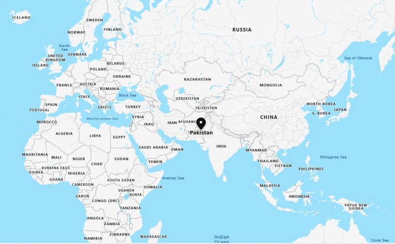
Where is Pakistan located on the world map?
The given Pakistan location map shows that Pakistan is located in the South Asia. Pakistan map also shows that it shares its international boundaries with Afghanistan in the west and north-west, China in the far north-east, Indian in the east, and Iran in the south-west. However, it has coastline with the Arabian Sea. Interestingly, Pakistan is the place of one of the oldest civilizations and various ancient cultures. Pakistan got its independence from the British Empire in the year 14 August 1947. However, it adopted a new constitution in the year 1956; thereupon, it is known as Islamic republic. So, the government type of Pakistan is a federal parliamentary republic comprising of four provinces and four federal territories.
The economy of the country depends collectively upon some of the significant sectors including agriculture, services, and other manufacturing sectors. However, due to infrastructure development and foreign investment, today, services have maximum contribution i.e. about 53 percent of total GDP.
Moreover, climate type of Pakistan varies from tropical to temperate with arid conditions present in the coastal south, featured with a monsoon season with enough rainfall and a dry season with lesser rainfall. In spite of being threat-full region because of terrorism, the tourism in Pakistan is still growing. Since, there is lot of tourists places with plenty of cultures, tourists across the globe come to enjoy them.
Where is Pakistan Located?
The given Pakistan location map shows that Pakistan is located in the South Asia. Pakistan map also shows that it shares its international boundaries with Afghanistan in the west and north-west, China in the far north-east, Indian in the east, and Iran in the south-west. However, it has coastline with the Arabian Sea. Interestingly, Pakistan is the place of one of the oldest civilizations and various ancient cultures. Pakistan got its independence from the British Empire in the year 14 August 1947. However, it adopted a new constitution in the year 1956; thereupon, it is known as Islamic republic. So, the government type of Pakistan is a federal parliamentary republic comprising of four provinces and four federal territories.
The economy of the country depends collectively upon some of the significant sectors including agriculture, services, and other manufacturing sectors. However, due to infrastructure development and foreign investment, today, services have maximum contribution i.e. about 53 percent of total GDP.
Moreover, climate type of Pakistan varies from tropical to temperate with arid conditions present in the coastal south, featured with a monsoon season with enough rainfall and a dry season with lesser rainfall. In spite of being threat-full region because of terrorism, the tourism in Pakistan is still growing. Since, there is lot of tourists places with plenty of cultures, tourists across the globe come to enjoy them.
Location Map of Asian Countries
- Where is Afghanistan
- Where is Armenia
- Where is Azerbaijan
- Where is Bahrain
- Where is Bangladesh
- Where is Bhutan
- Where is Brunei
- Where is Cambodia
- Where is China
- Where is Georgia
- Where is Hong Kong
- Where is India
- Where is Indonesia
- Where is Iran
- Where is Iraq
- Where is Israel
Popular Asian Cities
- Where is Abu Dhabi
- Where is Amman
- Where is Ankara
- Where is Baghdad
- Where is Baku
- Where is Bangkok
- Where is Bangalore
- Where is Beijing
- Where is Bishkek
- Where is Damascus
- Where is Dhaka
- Where is Dubai


