
Written and Fact-checked by Whereig Editors | Last Updated On: June 17, 2026
Manila is the capital city of the Philippines, located in the National Capital Region on the island of Luzon. Situated at approximately 14.5995° N latitude and 120.9842° E longitude, the city covers about 42.9 sq km (16.6 sq mi) and has an estimated population of around 1.9 million people.
Location Map of Manila, Philippines
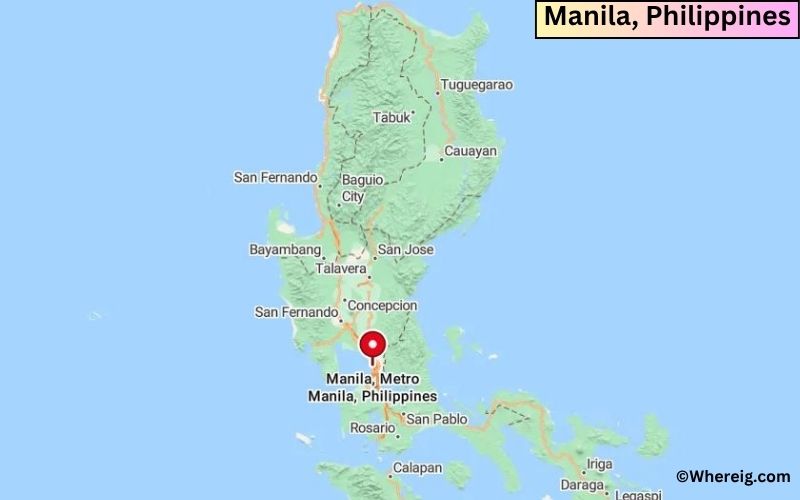
About Map: The map shows the location of Manila in the Philippines.
Where is Manila Located?
For the administrative reason, the city is divided into six legislative districts, which consists of sixteen geographical districts. In addition, Manila is the center of various scientific and educational institutions, as well as numerous sport facilities. These features facilitate the city as a major political, commercial, cultural, educational, religious, cosmopolitan, and transportation center of the Philippines.
Manila port is one of the most developed sea-port in the world. The economy of city largely depends upon the export and manufacturing chemicals, textiles, clothing, and electronic goods. Besides, the coconut and copra oil are also being produced.
Manila, National Capital Region Quick Facts
| Fact | Details |
|---|---|
| City | Manila |
| Region | National Capital Region (Metro Manila) |
| Country | Philippines |
| National Capital | Manila |
| Region | Luzon |
| Latitude | 14.5995° N |
| Longitude | 120.9842° E |
| Elevation | 52 ft (16 m) |
| Land Area | 16.7 sq mi |
| Water Area | Includes Manila Bay and Pasig River waterways |
| Total Area | 16.7 sq mi |
| Population (Latest Estimate) | Approximately 1.9 million |
| Population Density | Approximately 113,000 per sq mi |
| Postal Codes | 0900-1096 |
| Area Code | +63 2 |
| Time Zone Standard | Philippine Time (UTC+8) |
| Time Zone Daylight | No daylight saving time observed |
| Currency | Philippine Peso (PHP) |
| Administrative Code | City of Manila |
| National Representation | Congressional Districts of Manila |
Nearby Cities to Manila, Philippines
- Pasay, Philippines - 4 mi South
- Makati, Philippines - 5 mi Southeast
- Quezon City, Philippines - 7 mi Northeast
- Mandaluyong, Philippines - 5 mi East
- San Juan, Philippines - 4 mi East
- Caloocan, Philippines - 6 mi North
- Taguig, Philippines - 9 mi Southeast
- Parañaque, Philippines - 8 mi South
- Pasig, Philippines - 8 mi East
- Marikina, Philippines - 11 mi Northeast
Manila, Philippines Climate and Weather Overview
| Month | Avg High (°F) | Avg Low (°F) | Avg Rainfall (in) |
|---|---|---|---|
| January | 86 | 73 | 0.8 |
| April | 93 | 78 | 0.8 |
| July | 88 | 77 | 13.4 |
| October | 88 | 76 | 7.8 |
| Annual | 89 | 76 | 78.0 |
| Climate Attribute | Details |
|---|---|
| Climate Classification (Köppen) | Aw - Tropical Savanna |
| Annual Rainfall | Approximately 78 inches |
| Annual Sunshine Days | Approximately 210 sunny days |
| Hurricane/Tornado Risk | Moderate to High Typhoon Risk |
| Snowfall | No snowfall |
Driving Distances from Manila, Philippines
| City | Province/Region | Distance (mi) | Approx. Drive Time |
|---|---|---|---|
| Pasay | Metro Manila | 4 | 15 min |
| Makati | Metro Manila | 5 | 20 min |
| Mandaluyong | Metro Manila | 5 | 20 min |
| Caloocan | Metro Manila | 6 | 20 min |
| Quezon City | Metro Manila | 7 | 25 min |
| Pasig | Metro Manila | 8 | 25 min |
| Parañaque | Metro Manila | 8 | 25 min |
| Taguig | Metro Manila | 9 | 30 min |
| Marikina | Metro Manila | 11 | 35 min |
| Antipolo | Rizal | 15 | 40 min |
Transportation and Connectivity in Manila, Philippines
| Airport Name | Ninoy Aquino International Airport |
| IATA Code | MNL |
| Port | Port of Manila |
| Major Highways | EDSA, Roxas Boulevard, South Luzon Expressway, North Luzon Expressway |
| Train Service | LRT-1, LRT-2, MRT-3 and Philippine National Railways |
| Local Transit Service | Jeepneys, Buses, Trains, Taxis and Ferry Services |
- EDSA - Main highway connecting cities throughout Metro Manila.
- Roxas Boulevard - Scenic waterfront route along Manila Bay.
- South Luzon Expressway - Connects Metro Manila with southern Luzon.
- North Luzon Expressway - Major route toward Central and Northern Luzon.
- Skyway System - Elevated expressway serving metropolitan traffic.
Key Landmarks and Places to Visit in Manila, Philippines
| Landmark Name | Type |
|---|---|
| Intramuros | Historic District |
| Rizal Park | Urban Park |
| Fort Santiago | Historic Fortress |
| Manila Cathedral | Religious Site |
| San Agustin Church | UNESCO Site |
| National Museum of the Philippines | Museum |
| Manila Ocean Park | Aquarium |
| Binondo | Historic Chinatown |
| Malacañang Palace | Government Landmark |
| Baywalk Manila | Waterfront Promenade |
Places to Visit in Manila, Philippines
| Landmark Name | Type |
|---|---|
| Intramuros | Historic District |
| Rizal Park | Urban Park |
| Fort Santiago | Historic Fortress |
| Manila Cathedral | Religious Site |
| San Agustin Church | UNESCO Site |
| National Museum of the Philippines | Museum |
| Manila Ocean Park | Aquarium |
| Binondo | Historic Chinatown |
| Malacañang Palace | Government Landmark |
| Baywalk Manila | Waterfront Promenade |
Colleges and Universities in Manila, Philippines
| Institution Name | Type | Level | Notable For |
|---|---|---|---|
| University of the Philippines Manila | Public | University | Medical education |
| University of Santo Tomas | Private | University | Historic higher education |
| De La Salle University | Private | University | Business and research |
| Adamson University | Private | University | Engineering programs |
| Pamantasan ng Lungsod ng Maynila | Public | University | Local government education |
Waterbodies in Manila, Philippines
Manila Bay, Pasig River, Marikina River, Laguna de Bay, Estero de Binondo, Estero de San Miguel, Estero de Paco, Navotas River, San Juan River, Manila South Harbor
Golf Courses in Manila, Philippines
Manila Southwoods Golf & Country Club, Wack Wack Golf & Country Club, Villamor Golf Club, Intramuros Golf Club, Philippine Navy Golf Club, Camp Aguinaldo Golf Course, Club Intramuros Golf Course, Valley Golf and Country Club, Southlinks Golf Club, Forest Hills Golf & Country Club
Manila, Philippines - Key Historical Facts
- Manila was established as a Spanish colonial city in 1571 and became the center of Spanish rule in Asia.
- The city played a major role in the Manila-Acapulco Galleon Trade that connected Asia and the Americas.
- Intramuros served as the fortified administrative and religious center during the Spanish era.
- Manila experienced extensive destruction during World War II and was rebuilt after the conflict.
- The city became the political and cultural heart of the modern Philippines following independence.
- Today, Manila remains one of Southeast Asia's most important historical, economic and cultural centers.
References
- City Government of Manila
- Philippine Statistics Authority
- Department of Tourism Philippines
- Encyclopaedia Britannica - Manila