
Written and Fact-checked by Whereig Editors | Last Updated On: June 18, 2026
Bangkok is the capital city of Thailand, located in the central part of the country along the Chao Phraya River. Situated at approximately 13.7563° N latitude and 100.5018° E longitude, the city covers about 1,569 sq km (606 sq mi) and has an estimated population of around 5.5 million people.
Location Map of Bangkok, Thailand
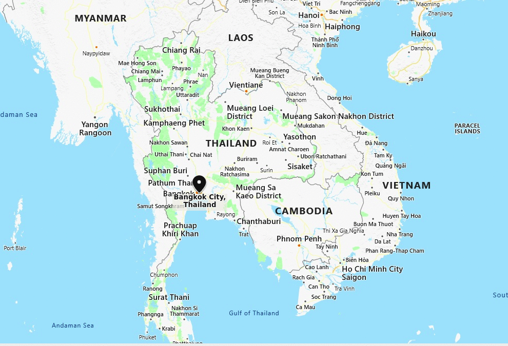
About Map: The map shows the location of Bangkok in the Thailand.
Where is Bangkok Located?
In the passage of time, Bangkok has grown enough to become the political, social and economic center of Thailand. Likewise, in the recent decades, city has experienced tremendous growth because of especially investment boom, opening of various MNCs headquarters, and other infrastructure development.
These facilities made Bangkok as the center of finance and business in the region. Because of increasing influence on global politics, culture, fashion and entertainment underlines it has been given the status of an Alpha global city.
Furthermore, city's historic wealth corresponding with the swift modernization reflects in the cityscape and the urban society. For the tourist's point of view, the city is one of the famous landmarks in south-east Asia that entertains tourists the fullest; it is synonymous of exoticism. Important tourist's points are: the Grand Palace, Wat Arun, Vimanmek Palace Complex, its thousands of temples, and the city's notorious red-light districts unite to draw nearly 10 million international visitors each year, second only after London.
Bangkok, Bangkok Metropolitan Administration Quick Facts
| Fact | Details |
|---|---|
| City | Bangkok |
| Administrative Division | Bangkok Metropolitan Administration |
| Country | Thailand |
| National Capital | Bangkok |
| Region | Central Thailand |
| Latitude | 13.7563° N |
| Longitude | 100.5018° E |
| Elevation | 5 ft (1.5 m) |
| Land Area | 605 sq mi |
| Water Area | Includes rivers, canals and reservoirs |
| Total Area | 605 sq mi |
| Population (Latest Estimate) | Approximately 5.5 million |
| Population Density | Approximately 9,100 per sq mi |
| Postal Codes | 10100-10900 |
| Area Code | +66 2 |
| Time Zone Standard | Indochina Time (UTC+7) |
| Time Zone Daylight | No daylight saving time observed |
| Currency | Thai Baht (THB) |
| Administrative Code | Bangkok Metropolitan Administration |
| National Representation | House of Representatives Constituencies |
Nearby Cities to Bangkok, Thailand
- Nonthaburi, Thailand - 8 mi Northwest
- Pak Kret, Thailand - 12 mi North
- Samut Prakan, Thailand - 18 mi Southeast
- Pathum Thani, Thailand - 20 mi North
- Bang Bua Thong, Thailand - 17 mi Northwest
- Nakhon Pathom, Thailand - 34 mi West
- Ayutthaya, Thailand - 48 mi North
- Chachoengsao, Thailand - 40 mi East
- Pattaya, Thailand - 92 mi Southeast
- Rayong, Thailand - 112 mi Southeast
Bangkok, Thailand Climate and Weather Overview
| Month | Avg High (°F) | Avg Low (°F) | Avg Rainfall (in) |
|---|---|---|---|
| January | 91 | 72 | 0.4 |
| April | 96 | 79 | 2.6 |
| July | 91 | 78 | 6.1 |
| October | 90 | 76 | 9.5 |
| Annual | 92 | 76 | 59.0 |
| Climate Attribute | Details |
|---|---|
| Climate Classification (Köppen) | Aw - Tropical Savanna |
| Annual Rainfall | Approximately 59 inches |
| Annual Sunshine Days | Approximately 2,600 sunshine hours |
| Hurricane/Tornado Risk | Low Tropical Storm Risk |
| Snowfall | No snowfall |
Driving Distances from Bangkok, Thailand
| City | Province | Distance (mi) | Approx. Drive Time |
|---|---|---|---|
| Nonthaburi | Nonthaburi | 8 | 20 min |
| Pak Kret | Nonthaburi | 12 | 25 min |
| Bang Bua Thong | Nonthaburi | 17 | 30 min |
| Samut Prakan | Samut Prakan | 18 | 30 min |
| Pathum Thani | Pathum Thani | 20 | 35 min |
| Nakhon Pathom | Nakhon Pathom | 34 | 50 min |
| Chachoengsao | Chachoengsao | 40 | 1 hr |
| Ayutthaya | Phra Nakhon Si Ayutthaya | 48 | 1 hr 10 min |
| Pattaya | Chonburi | 92 | 1 hr 45 min |
| Rayong | Rayong | 112 | 2 hr |
Transportation and Connectivity in Bangkok, Thailand
| Airport Name | Suvarnabhumi Airport |
| IATA Code | BKK |
| Port | Bangkok Port (Khlong Toei Port) |
| Major Highways | Highway 1, Highway 9, Motorway 7, Expressway Network |
| Train Service | State Railway of Thailand, High-Speed Rail Development, Airport Rail Link |
| Local Transit Service | BTS Skytrain, MRT, Buses, River Ferries and Taxis |
- Highway 1 - Connects Bangkok with northern Thailand.
- Motorway 7 - Main route linking Bangkok with Pattaya and the Eastern Seaboard.
- Highway 9 - Outer Ring Road serving the metropolitan area.
- BTS Skytrain - Elevated rail network serving key commercial districts.
- MRT Network - Underground and rapid transit system connecting major city zones.
Key Landmarks and Places to Visit in Bangkok, Thailand
| Landmark Name | Type |
|---|---|
| Grand Palace | Historic Palace |
| Wat Arun | Temple |
| Wat Phra Kaew | Religious Landmark |
| Chatuchak Market | Market |
| Lumphini Park | Urban Park |
| Jim Thompson House | Museum |
| ICONSIAM | Shopping Complex |
| Chao Phraya Riverfront | Waterfront Area |
| Yaowarat | Cultural District |
| Asiatique The Riverfront | Entertainment District |
Places to Visit in Bangkok, Thailand
| Landmark Name | Type |
|---|---|
| Grand Palace | Historic Palace |
| Wat Arun | Temple |
| Wat Phra Kaew | Religious Landmark |
| Chatuchak Market | Market |
| Lumphini Park | Urban Park |
| Jim Thompson House | Museum |
| ICONSIAM | Shopping Complex |
| Chao Phraya Riverfront | Waterfront Area |
| Yaowarat | Cultural District |
| Asiatique The Riverfront | Entertainment District |
Colleges and Universities in Bangkok, Thailand
| Institution Name | Type | Level | Notable For |
|---|---|---|---|
| Chulalongkorn University | Public | University | Thailand's premier university |
| Thammasat University | Public | University | Law and political science |
| Kasetsart University | Public | University | Agriculture and research |
| Mahidol University | Public | University | Medicine and health sciences |
| Bangkok University | Private | University | Business and communications |
Waterbodies in Bangkok, Thailand
Chao Phraya River, Bangkok Noi Canal, Bangkok Yai Canal, Saen Saep Canal, Bang Pakong River, Phra Pradaeng Canal, Bung Kum Lake, Rama IX Reservoir, Lat Phrao Canal, Tha Chin River
Golf Courses in Bangkok, Thailand
Thai Country Club, Alpine Golf Club, Muang Kaew Golf Course, Navatanee Golf Course, Summit Windmill Golf Club, Thana City Country Club, Royal Bangkok Sports Club Golf Course, Riverdale Golf Club, Nikanti Golf Club, Pinehurst Golf & Country Club
Bangkok, Thailand - Key Historical Facts
- Bangkok became the capital of Siam in 1782 when King Rama I established the Chakri Dynasty.
- The city developed around the Chao Phraya River, which served as a major transportation and trade route.
- Bangkok grew into Southeast Asia's leading commercial and political center during the nineteenth and twentieth centuries.
- Its historic temples and royal palaces reflect centuries of Thai cultural and architectural heritage.
- Rapid urbanization transformed Bangkok into one of Asia's largest metropolitan areas.
- Today, Bangkok is Thailand's political, economic and cultural center and a major international tourism destination.
References
- Bangkok Metropolitan Administration
- National Statistical Office of Thailand
- Tourism Authority of Thailand
- Encyclopaedia Britannica - Bangkok