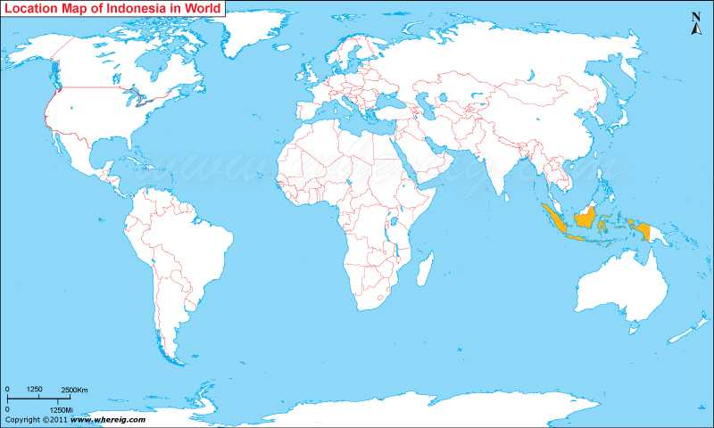
Indonesia, officially the Republic of Indonesia, is a country located in Southeast Asia and Oceania between the Indian and Pacific oceans. Indonesia is the world's largest island country and the 14th-largest country by area, It covers an area of 735,358 square miles (1,904,569 square kilometres). Jakarta, its current capital, Indonesia has announced that its new capital will be called Nusantara.
At least 162 dead after Magnitude 6.9 earthquake hits Indonesia's Java island. 203 km from Bengkulu City, Bengkulu, Indonesia.
Where is Indonesia located in the World map?
 About Map: Map showing location of Indonesia in Southeast Asia and Oceania between the Indian and Pacific oceans.
| Where is Jakarta | Sumatra Map | Where is Nusantara |
Where is Indonesia Located?
The given Indonesia location map shows the accurate geographical position of Indonesia. It is a country largely of Southeast Asia and partly of Oceania. So, Indonesia is the country of group of islands located in the Indian Ocean and Pacific Ocean surrounded by many small seas. There are about 17,508 islands which collectively consist Indonesia. Surprisingly, this island country is fourth most populated country of the world. Jakarta, its current capital, is located on the island of Java.
The government type of Indonesia is a Unitary Presidential Republic, with an elected legislature and president. Indonesia is a founding member of international organization ASEAN and also a member of the G-20 major economies countries. Though, the country is group of islands nonetheless, it shares its international boundaries with Papua New Guinea, East Timor, and Malaysia. Besides, the neighboring countries are Singapore, Australia, Philippines, and Andaman and Nicobar Islands of India. The largest islands are Java, Sumatra, Borneo (Borneo also shared by Brunei and Malaysia), New Guinea (also shared by Papua New Guinea), and Sulawesi. Indonesia has a tropical climate, with monsoonal characteristics i.e. wet and dry seasons.
Throughout the islands, Indonesia houses distinct ethnic, linguistic, and religious groups. The Java people are the largest group and also the politically dominant ethnic group. Likewise, Indonesia has developed an amalgamated distinctiveness defined by a national language, religious pluralism, and ethnic diversity.
Moreover, Indonesia has plenty of tourist places to visit including Jakarta the capital city, beach resorts of Bali and Lombok, and the fantastic islands of Java, Sumatra and Kalimantan. All these beautiful places lie in the lap of tropical rainforests. This is the reason that the Indonesia tourism attracts thousands of international tourists every year.
Indonesia Geography & Facts
| Continent | Asia |
| Location | Southeast Asia |
| Coordinates | 0.7893° S, 113.9213° E |
| Capital and largest city | Jakarta |
| Proposed Capital | Nusantara |
| Official language and national language | Indonesian |
| Regional languages | Over 700 languages |
| Religion (2018) | 86.70% Islam, 10.72% Christianity, 1.74% Hinduism, 0.77% Buddhism, 0.04% Folk/Other, 0.03% Confucianism |
| Demonym(s) | Indonesian |
| Government | Unitary presidential constitutional republic |
| Independence from the Netherlands | Proclaimed - 17 August 1945 and Recognition - 27 December 1949 |
| Area Land | 1,904,569[6] km2 (735,358 sq mi) (14th) |
| • Water (%) | 4.85 |
| Population (2020 census) | 270,203,917 (4th) |
| GDP (PPP) | 2022 estimate |
| Currency | Indonesian rupiah (Rp) (IDR) |
| Time zone | UTC+7 to +9 (various) |
| Mains electricity | 220 V-50 Hz |
| Driving side | left |
| Calling code | 62 |
| ISO 3166 code | ID |
| Internet TLD | .id |
- Where is Afghanistan
- Where is Armenia
- Where is Azerbaijan
- Where is Bahrain
- Where is Bangladesh
- Where is Bhutan
- Where is Brunei
- Where is Cambodia
- Where is China
- Where is Georgia
- Where is Hong Kong
- Where is India
- Where is Indonesia
- Where is Iran
- Where is Iraq
- Where is Israel
- Where is Japan
- Where is Jordan
- Where is Kazakhstan
- Where is Kuwait
- Where is Kyrgyzstan
- Where is Laos
- Where is Lebanon
- Where is Macau
- Where is Malaysia
- Where is Maldives
- Where is Mongolia
- Where is Myanmar
- Where is Nepal
- Where is North Korea
- Where is Oman
- Where is Pakistan
- Where is Philippines
- Where is Qatar
- Where is Russia
- Where is Saudi Arabia
- Where is Singapore
- Where is South Korea
- Where is Sri Lanka
- Where is Syria
- Where is Taiwan
- Where is Tajikistan
- Where is Thailand
- Where is Turkey
- Where is Turkmenistan
- United Arab Emirates
- Where is Uzbekistan
- Where is Vietnam
- Where is Yemen
- Where is Abu Dhabi
- Where is Amman
- Where is Ankara
- Where is Baghdad
- Where is Baku
- Where is Bangkok
- Where is Bangalore
- Where is Beijing
- Where is Bishkek
- Where is Damascus
- Where is Dhaka
- Where is Dubai
- Where is Doha
- Where is Hanoi
- Where is Islamabad
- Where is Jakarta
- Where is Jerusalem
- Where is Kabul
- Where is Kathmandu
- Where is Kuala Lumpur
- Where is Kuwait City
- Where is Manila
- Where is Moscow
- Where is Mumbai
- Where is Muscat
- Where is New Delhi
- Where is Riyadh
- Where is Sanaa
- Where is Shanghai
- Where is Seoul
- Where is Taipei
- Where is Tehran
- Where is Tokyo
