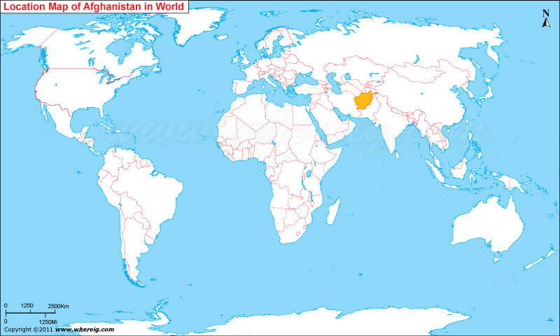
Afghanistan Officialy known as Islamic republic of Afghanistan, is a country, located in the South-Central Asia and lies between latitudes 33.0° North and longitudes 65.0° East.
Afghanistan Location in World Map

| | ||
Where is Afghanistan Located?
Afghanistan is a landlocked and a mountainous country located in the South-Central Asia. Its the world 41st largest country. It covers an area of 652,864 sq km (252,072 sq mi). Afghanistan shares its international boundary with Pakistan to the east and south, Iran to the west, Turkmenistan, Uzbekistan, and Tajikistan to the north, and China to the northeast. Kabul is the capital and largest city in Afghanistan.
Kandahar, Herat, Mazar-e-Sharif, Jalalabad, Konduz are its famous cities among the rest eleven. Its population cover 31,390 million people.2.629% is its annual population growth rate. Mountains and deserts are its common scenic view. Kabul bala hisar, Kabul museum, Gardens ofBabur, Arg(palace), Mausoleums, Bazaars and Mosques are its famous tourist place. Muslim is the main religion and afghan Persian and Pashtu is the mostly spoken language. Afghani is its currency name.
What is the capital of Afghanistan?
The capital of Afghanistan is its largest city, Kabul, situated on the Kabul river which is one of the highest capital city.
Afghanistan Information and Facts
| Official Name | Islamic State of Afghanistan |
| Continent | Asia |
| Region | South Asia |
| Coordinates | 33°00′N 65°00′E |
| Capital | Kabul |
| Largest City | Kabul |
| Administrative divisions | 34 provinces |
| Afghanistan National Day | 19 August |
| Area of Afghanistan | 652,864 km2 (252,072 sq mi) (40th) |
| Neighboring Country | Pakistan, Iran, Turkmenistan, Uzbekistan, Tajikistan and China |
| Population of Afghanistan | 31,390,200 [2020 estimate] (44th) |
| Official Language | Dari, Pashto |
| Currency of Afghanistan | Afghani (افغانی) (AFN) |
| Afghanistan Airports | Hamid Karzai International Airport (Kabul) |
| ISO Alpha-2 Code | AF |
| ISO Alpha-3 Code | AFN |
| GDP 2020 estimate | $72.911 billion (96th) |
| Afghanistan Calling code | +93 |
| Afghanistan Time Zone | UTC+4:30 Solar Calendar (D†) |
| Climate | Continental climate |
| Longest river | Helmand River |
| Largest lake | Kajaki Dam, Dahla Dam, Naghlu Dam, Band-e Amir, Qargha |
| Natural resources | Natural gas, petroleum, coal, copper, chromite, talc, barites, sulfur, lead, zinc, iron ore, salt, precious and semiprecious Stone |
| Natural hazards | earthquakes, flooding, avalanches |
| Highest point | Noshaq, 7,492 m (24,580 ft) |
| Lowest point | Helmand River |
| Internet TLD | .af |
Afghanistan - 10 Largest Cities
| S.N | Name | Province | Population (2019) |
|---|---|---|---|
| 1 | Kabul | Kabul Province | 4,273,200 |
| 2 | Kandahar | Kandahar Province | 614,300 |
| 3 | Herat | Herat Province | 556,200 |
| 4 | Mazar-i-Sharif | Balkh Province | 469,200 |
| 5 | Jalalabad | Nangarhar Province | 356,500 |
| 6 | Kunduz | Kunduz Province | 263,200 |
| 7 | Taloqan | Takhar Province | 253,700 |
| 8 | Puli Khumri | Baghlan Province | 237,900 |
| 9 | Ghazni | Ghazni Province | 183,000 |
| 10 | Khost | Khost Province | 153,300 |
- Where is Afghanistan
- Where is Armenia
- Where is Azerbaijan
- Where is Bahrain
- Where is Bangladesh
- Where is Bhutan
- Where is Brunei
- Where is Cambodia
- Where is China
- Where is Georgia
- Where is Hong Kong
- Where is India
- Where is Indonesia
- Where is Iran
- Where is Iraq
- Where is Israel
- Where is Japan
- Where is Jordan
- Where is Kazakhstan
- Where is Kuwait
- Where is Kyrgyzstan
- Where is Laos
- Where is Lebanon
- Where is Macau
- Where is Malaysia
- Where is Maldives
- Where is Mongolia
- Where is Myanmar
- Where is Nepal
- Where is North Korea
- Where is Oman
- Where is Pakistan
- Where is Philippines
- Where is Qatar
- Where is Russia
- Where is Saudi Arabia
- Where is Singapore
- Where is South Korea
- Where is Sri Lanka
- Where is Syria
- Where is Taiwan
- Where is Tajikistan
- Where is Thailand
- Where is Turkey
- Where is Turkmenistan
- United Arab Emirates
- Where is Uzbekistan
- Where is Vietnam
- Where is Yemen
- Where is Abu Dhabi
- Where is Amman
- Where is Ankara
- Where is Baghdad
- Where is Baku
- Where is Bangkok
- Where is Bangalore
- Where is Beijing
- Where is Bishkek
- Where is Damascus
- Where is Dhaka
- Where is Dubai
- Where is Doha
- Where is Hanoi
- Where is Islamabad
- Where is Jakarta
- Where is Jerusalem
- Where is Kabul
- Where is Kathmandu
- Where is Kuala Lumpur
- Where is Kuwait City
- Where is Manila
- Where is Moscow
- Where is Mumbai
- Where is Muscat
- Where is New Delhi
- Where is Riyadh
- Where is Sanaa
- Where is Shanghai
- Where is Seoul
- Where is Taipei
- Where is Tehran
- Where is Tokyo
