
Written and Fact-checked by Whereig Editors | Last Updated On: June 16, 2026
Where is Havana Located on the Cuba Map? Find Havana’s location map, coordinates, population, nearby cities, attractions, roads and highways, climate, transportation, and important city facts.
Location Map of Havana, Cuba
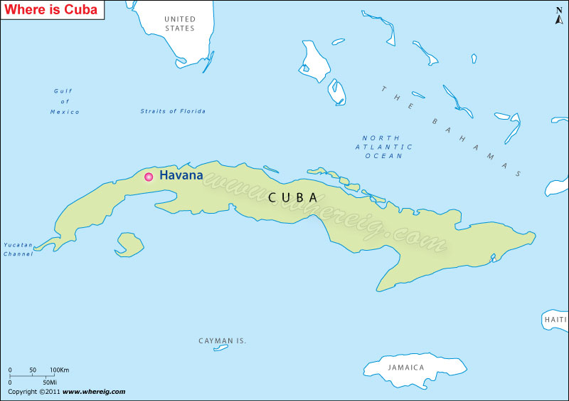
About Map: The map shows the location of Havana in the Cuba.
Where is Melbourne Located?
Havana is separated by Florida Strait from the United States. Havana is the largest (largest in the Caribbean region) and capital city of Cuba situated at the coast of Gulf of Mexico. It is a port city and leading commercial center of Cuba.
The title of Havana was granted by King Philip II of Spain in the year 1592. By virtue of being a port city, Havana is developed fast. Its economy largely runs over Sugar industry and tourism. Havana resorts are very much fascinating for the tourists across the world.
Havana, La Habana Quick Facts
| Fact | Details |
|---|---|
| City | Havana |
| Province | La Habana |
| Country | Cuba |
| National Capital | Havana |
| Region | Caribbean |
| Latitude | 23.1136° N |
| Longitude | 82.3666° W |
| Elevation | 194 ft (59 m) |
| Land Area | 281 sq mi |
| Water Area | Includes Havana Bay and coastal waters |
| Total Area | 281 sq mi |
| Population (Latest Estimate) | Approximately 2.1 million |
| Population Density | Approximately 7,470 per sq mi |
| Postal Codes | 10100-19999 |
| Area Code | +53 7 |
| Time Zone Standard | Cuba Standard Time (UTC-5) |
| Time Zone Daylight | Cuba Daylight Time (UTC-4) |
| Currency | Cuban Peso (CUP) |
| Administrative Code | La Habana Province Administration |
| National Representation | Multiple National Assembly Constituencies |
Nearby Cities to Havana, Cuba
- San Antonio de los Baños, Cuba - 18 mi Southwest
- Guanajay, Cuba - 21 mi West
- Artemisa, Cuba - 33 mi Southwest
- Santa Cruz del Norte, Cuba - 28 mi East
- Madruga, Cuba - 38 mi Southeast
- Jaruco, Cuba - 22 mi East
- Güines, Cuba - 31 mi Southeast
- Matanzas, Cuba - 63 mi East
- Mariel, Cuba - 28 mi West
- Batabanó, Cuba - 34 mi South
Havana, Cuba Climate and Weather Overview
| Month | Avg High (°F) | Avg Low (°F) | Avg Rainfall (in) |
|---|---|---|---|
| January | 79 | 64 | 2.5 |
| April | 86 | 69 | 2.1 |
| July | 90 | 74 | 4.6 |
| October | 86 | 72 | 6.9 |
| Annual | 85 | 70 | 49.0 |
| Climate Attribute | Details |
|---|---|
| Climate Classification (Köppen) | Aw - Tropical Savanna |
| Annual Rainfall | Approximately 49 inches |
| Annual Sunshine Days | More than 250 sunny days |
| Hurricane/Tornado Risk | Moderate Hurricane Risk |
| Snowfall | No snowfall |
Driving Distances from Havana, Cuba
| City | Province | Distance (mi) | Approx. Drive Time |
|---|---|---|---|
| San Antonio de los Baños | Artemisa | 18 | 30 min |
| Guanajay | Artemisa | 21 | 35 min |
| Artemisa | Artemisa | 33 | 50 min |
| Jaruco | Mayabeque | 22 | 35 min |
| Güines | Mayabeque | 31 | 45 min |
| Santa Cruz del Norte | Mayabeque | 28 | 40 min |
| Mariel | Artemisa | 28 | 40 min |
| Batabanó | Mayabeque | 34 | 50 min |
| Matanzas | Matanzas | 63 | 1 hr 20 min |
| Varadero | Matanzas | 88 | 1 hr 45 min |
Transportation and Connectivity in Havana, Cuba
| Airport Name | José Martí International Airport |
| IATA Code | HAV |
| Port | Port of Havana |
| Major Highways | Autopista Nacional, Carretera Central, Via Blanca |
| Train Service | Ferrocarriles de Cuba |
| Local Transit Service | Public Buses, Shared Taxis and Urban Rail |
- Autopista Nacional - Cuba's principal highway connecting Havana with eastern provinces.
- Carretera Central - Historic roadway linking major cities across the island.
- Via Blanca - Coastal route connecting Havana and Matanzas.
- Avenida Boyeros - Main access route to José Martí International Airport.
- Malecón Corridor - Important urban coastal roadway through central Havana.
Key Landmarks and Places to Visit in Havana, Cuba
| Landmark Name | Type |
|---|---|
| Old Havana | Historic District |
| El Capitolio | Historic Building |
| Malecón | Waterfront Promenade |
| Castillo del Morro | Historic Fortress |
| Plaza de la Catedral | Historic Square |
| Museum of the Revolution | Museum |
| Gran Teatro de La Habana | Theater |
| Fusterlandia | Art Attraction |
| Plaza Vieja | Historic Square |
| National Museum of Fine Arts | Museum |
Places to Visit in Havana, Cuba
| Landmark Name | Type |
|---|---|
| Old Havana | Historic District |
| El Capitolio | Historic Building |
| Malecón | Waterfront Promenade |
| Castillo del Morro | Historic Fortress |
| Plaza de la Catedral | Historic Square |
| Museum of the Revolution | Museum |
| Gran Teatro de La Habana | Theater |
| Fusterlandia | Art Attraction |
| Plaza Vieja | Historic Square |
| National Museum of Fine Arts | Museum |
Colleges and Universities in Havana, Cuba
| Institution Name | Type | Level | Notable For |
|---|---|---|---|
| University of Havana | Public | University | Oldest university in Cuba |
| Technological University of Havana | Public | University | Engineering education |
| University of Medical Sciences of Havana | Public | University | Medical training |
| Higher Institute of Art | Public | University | Arts education |
| University of Informatics Sciences | Public | University | Computer science |
Waterbodies in Havana, Cuba
Havana Bay, Straits of Florida, Almendares River, Quibú River, Bacuranao River, Ariguanabo River, Laguna del Cura, Laguna de Ariguanabo, Gulf of Mexico, Santa María del Mar Coast
Golf Courses in Havana, Cuba
Havana Golf Club, Varadero Golf Club, La Habana Golf Center, Club de Golf de Cuba, Capdevila Golf Practice Facility
Havana, Cuba - Key Historical Facts
- Havana was founded by the Spanish in 1519 and quickly became a strategic port in the Caribbean.
- The city served as a major staging point for Spanish treasure fleets traveling between the Americas and Europe.
- Numerous fortifications were built around Havana to protect it from pirates and foreign powers.
- During the nineteenth century, Havana became a major center for sugar production and international trade.
- The Cuban Revolution of 1959 dramatically reshaped the city's political and economic landscape.
- Today, Havana is renowned for its colonial architecture, classic automobiles, music, and UNESCO-listed historic center.
References
- Government of Cuba
- National Office of Statistics and Information (ONEI)
- Cuba Travel
- Encyclopaedia Britannica - Havana