
Written and Fact-checked by Whereig Editors | Last Updated On: June 17, 2026
Where is Dublin Located on the Ireland Map? Find Dublin’s location map, coordinates, population, nearby cities, attractions, roads and highways, climate, transportation, and important city facts.
Location Map of Dublin, Ireland
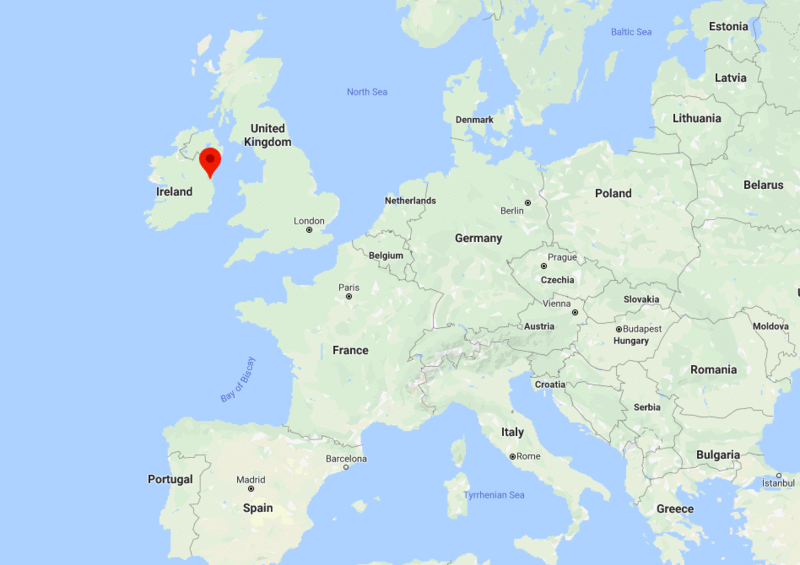
About Map: The map shows the location of Dublin in the Ireland.
Where is Dublin Located?
Dublin is the largest and capital city of Ireland situated at the coast of Irish Sea. The name Dublin is derived from the Irish name Dubh Linn, which means "Black Pool".
Dublin is the center of political, financial, commercial, media, transportation, and cultural activities. It is also ranked as Alpha Global City. Furthermore, Dublin is the modern and advanced center for education, arts, and industries.
The national parliament of Ireland is known as Oireachtas located in Dublin. It consists of the President of Ireland, the upper house Seanad Eireann (Senate), and the lower house Dail Eireann (House of Representatives).
Moreover, Dublin is also significant for tourists. Dublin has some of the beautiful landscapes that fascinate tourists to visit the city.
Dublin, County Dublin Quick Facts
| Fact | Details |
|---|---|
| City | Dublin |
| County | County Dublin |
| Country | Ireland |
| National Capital | Dublin |
| Region | Eastern Ireland |
| Latitude | 53.3498° N |
| Longitude | 6.2603° W |
| Elevation | 66 ft (20 m) |
| Land Area | 45 sq mi |
| Water Area | Includes Dublin Bay, River Liffey and canals |
| Total Area | 45 sq mi |
| Population (Latest Estimate) | Approximately 1.5 million (metropolitan area) |
| Population Density | Approximately 8,700 per sq mi |
| Postal Codes | D01-D24 |
| Area Code | +353 1 |
| Time Zone Standard | Greenwich Mean Time (UTC+0) |
| Time Zone Daylight | Irish Standard Time (UTC+1) |
| Currency | Euro (EUR) |
| Administrative Code | Dublin City Council |
| National Representation | Multiple Dáil Éireann Constituencies |
Nearby Cities to Dublin, Ireland
- Dún Laoghaire, Ireland - 7 mi Southeast
- Swords, Ireland - 8 mi North
- Tallaght, Ireland - 8 mi Southwest
- Blanchardstown, Ireland - 7 mi West
- Lucan, Ireland - 9 mi West
- Malahide, Ireland - 10 mi Northeast
- Bray, Ireland - 13 mi South
- Greystones, Ireland - 18 mi South
- Naas, Ireland - 22 mi Southwest
- Drogheda, Ireland - 34 mi North
Dublin, Ireland Climate and Weather Overview
| Month | Avg High (°F) | Avg Low (°F) | Avg Rainfall (in) |
|---|---|---|---|
| January | 47 | 37 | 2.8 |
| April | 55 | 40 | 2.1 |
| July | 67 | 54 | 2.3 |
| October | 58 | 46 | 3.0 |
| Annual | 57 | 44 | 30.0 |
| Climate Attribute | Details |
|---|---|
| Climate Classification (Köppen) | Cfb - Oceanic |
| Annual Rainfall | Approximately 30 inches |
| Annual Sunshine Days | Approximately 150 sunny days |
| Hurricane/Tornado Risk | Very Low |
| Snowfall | Approximately 5 inches annually |
Driving Distances from Dublin, Ireland
| City | County | Distance (mi) | Approx. Drive Time |
|---|---|---|---|
| Dún Laoghaire | Dublin | 7 | 20 min |
| Swords | Dublin | 8 | 20 min |
| Tallaght | Dublin | 8 | 20 min |
| Blanchardstown | Dublin | 7 | 20 min |
| Lucan | Dublin | 9 | 25 min |
| Malahide | Dublin | 10 | 25 min |
| Bray | Wicklow | 13 | 30 min |
| Greystones | Wicklow | 18 | 35 min |
| Naas | Kildare | 22 | 35 min |
| Drogheda | Louth | 34 | 45 min |
Transportation and Connectivity in Dublin, Ireland
| Airport Name | Dublin Airport |
| IATA Code | DUB |
| Port | Dublin Port |
| Major Highways | M1, M4, M7, M50, N11 |
| Train Service | Irish Rail (Iarnród Éireann), DART and Commuter Rail |
| Local Transit Service | Dublin Bus, Luas Tram and DART |
- M1 - Connects Dublin with Drogheda, Dundalk and Belfast.
- M4 - Major route linking Dublin with western Ireland.
- M7 - Connects the capital with Limerick and the southwest.
- M50 - Orbital motorway serving the Dublin metropolitan area.
- N11 - Coastal route connecting Dublin with County Wicklow and southeastern Ireland.
Key Landmarks and Places to Visit in Dublin, Ireland
| Landmark Name | Type |
|---|---|
| Trinity College Dublin | Historic University |
| Guinness Storehouse | Museum |
| Dublin Castle | Historic Castle |
| St. Patrick's Cathedral | Religious Site |
| Phoenix Park | Urban Park |
| Temple Bar | Cultural District |
| National Museum of Ireland | Museum |
| Ha'penny Bridge | Historic Bridge |
| Christ Church Cathedral | Religious Site |
| Kilmainham Gaol | Historic Site |
Places to Visit in Dublin, Ireland
| Landmark Name | Type |
|---|---|
| Trinity College Dublin | Historic University |
| Guinness Storehouse | Museum |
| Dublin Castle | Historic Castle |
| St. Patrick's Cathedral | Religious Site |
| Phoenix Park | Urban Park |
| Temple Bar | Cultural District |
| National Museum of Ireland | Museum |
| Ha'penny Bridge | Historic Bridge |
| Christ Church Cathedral | Religious Site |
| Kilmainham Gaol | Historic Site |
Colleges and Universities in Dublin, Ireland
| Institution Name | Type | Level | Notable For |
|---|---|---|---|
| Trinity College Dublin | Public | University | Historic research institution |
| University College Dublin | Public | University | Research and innovation |
| Dublin City University | Public | University | Technology and business |
| Technological University Dublin | Public | University | Applied education |
| Royal College of Surgeons in Ireland | Private | University | Medical education |
Waterbodies in Dublin, Ireland
River Liffey, Dublin Bay, River Tolka, River Dodder, Grand Canal, Royal Canal, Bull Island Lagoon, Broadmeadow Estuary, River Camac, Sandymount Strand
Golf Courses in Dublin, Ireland
Portmarnock Golf Club, Royal Dublin Golf Club, The Island Golf Club, Castle Golf Club, Luttrellstown Castle Golf Club, Elm Park Golf & Sports Club, St. Anne's Golf Club, Grange Golf Club, Corballis Links Golf Club, Deer Park Golf
Dublin, Ireland - Key Historical Facts
- Dublin originated as a Viking settlement established along the River Liffey during the ninth century.
- The city became the political and administrative center of Ireland under English rule.
- Trinity College Dublin was founded in 1592 and remains one of Ireland's most prestigious universities.
- Dublin played a central role in the 1916 Easter Rising, a key event in Ireland's independence movement.
- The city experienced significant economic growth during the late twentieth century as part of Ireland's Celtic Tiger era.
- Today, Dublin is Ireland's capital and serves as the country's leading center for business, technology, culture and government.
References
- Dublin City Council
- Central Statistics Office Ireland
- Tourism Ireland
- Encyclopaedia Britannica - Dublin