
Written and Fact-checked by Whereig Editors | Last Updated On: June 15, 2026
As shown in the given Mexico City location map that Mexico City is located in the Valley of Mexico, in the Trans-Mexican Volcanic Belt in the high plateaus of south-central region of Mexico. Mexico City is the largest and capital city of Mexico.
Location Map of Mexico City, Mexico
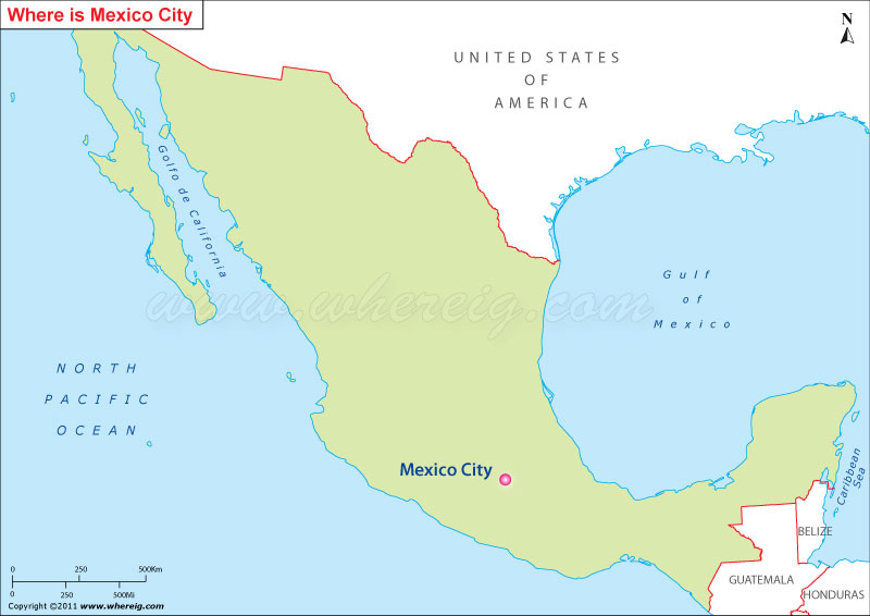
About Map: The map shows the location of Mexico City in the Mexico.
Where is Mexico City Located?
It has been given the status of Federal District capital of Mexico. In addition, it is the most significant center of Political, Cultural, educational, and financial activities. Above all, it is recognized as the "alpha" global city.
With the population 21.2 million, Mexico City is the largest metropolitan area in Americas and fifth largest agglomeration in the world. Surprisingly, the city is capable enough to generate more than 20 percent GDP of Mexico country that makes it one of the richest cities of the world.
Though, the city was founded a long back but in the middle period, it was colony of others; however, after the independence from Spain, the city was given the status of Federal District in the year 1824.
Moreover, in the recent past years, city has experienced a see-saw change by adopting liberal policies including abortion on request to any woman up to 12 weeks of the pregnancy, euthanasia on special circumstance but in limited way, no-fault divorce, and same-sex marriage.
Mexico City, Mexico City Quick Facts
| Fact | Details |
|---|---|
| City | Mexico City (Ciudad de México) |
| Federal Entity | Mexico City (CDMX) |
| Country | Mexico |
| National Capital | Mexico City |
| Region | Central Mexico |
| Latitude | 19.4326° N |
| Longitude | 99.1332° W |
| Elevation | 7,350 ft (2,240 m) |
| Land Area | 573 sq mi |
| Water Area | Includes lakes, canals and reservoirs |
| Total Area | 573 sq mi |
| Population (Latest Estimate) | Approximately 9.2 million |
| Population Density | Approximately 16,000 per sq mi |
| Postal Codes | 01000-16999 |
| Area Code | +52 55 |
| Time Zone Standard | Central Standard Time (UTC-6) |
| Time Zone Daylight | No daylight saving time observed |
| Currency | Mexican Peso (MXN) |
| Administrative Code | Ciudad de México (CDMX) |
| National Representation | Multiple Federal Electoral Districts |
Nearby Cities to Mexico City, Mexico
- Naucalpan, Mexico - 7 mi Northwest
- Tlalnepantla, Mexico - 8 mi North
- Ecatepec, Mexico - 12 mi Northeast
- Nezahualcóyotl, Mexico - 8 mi East
- Chimalhuacán, Mexico - 12 mi East
- Toluca, Mexico - 41 mi West
- Cuautitlán Izcalli, Mexico - 20 mi Northwest
- Texcoco, Mexico - 18 mi East
- Pachuca, Mexico - 58 mi Northeast
- Cuernavaca, Mexico - 54 mi South
Mexico City, Mexico Climate and Weather Overview
| Month | Avg High (°F) | Avg Low (°F) | Avg Rainfall (in) |
|---|---|---|---|
| January | 71 | 42 | 0.5 |
| April | 80 | 49 | 1.2 |
| July | 74 | 55 | 7.1 |
| October | 72 | 50 | 2.7 |
| Annual | 74 | 49 | 32.0 |
| Climate Attribute | Details |
|---|---|
| Climate Classification (Köppen) | Cwb - Subtropical Highland |
| Annual Rainfall | Approximately 32 inches |
| Annual Sunshine Days | Approximately 220 sunny days |
| Hurricane/Tornado Risk | Low |
| Snowfall | Very Rare |
Driving Distances from Mexico City, Mexico
| City | State | Distance (mi) | Approx. Drive Time |
|---|---|---|---|
| Naucalpan | State of Mexico | 7 | 20 min |
| Nezahualcóyotl | State of Mexico | 8 | 20 min |
| Tlalnepantla | State of Mexico | 8 | 20 min |
| Ecatepec | State of Mexico | 12 | 30 min |
| Chimalhuacán | State of Mexico | 12 | 30 min |
| Texcoco | State of Mexico | 18 | 35 min |
| Cuautitlán Izcalli | State of Mexico | 20 | 40 min |
| Toluca | State of Mexico | 41 | 1 hr |
| Cuernavaca | Morelos | 54 | 1 hr 15 min |
| Pachuca | Hidalgo | 58 | 1 hr 20 min |
Transportation and Connectivity in Mexico City, Mexico
| Airport Name | Mexico City International Airport |
| IATA Code | MEX |
| Port | No Seaport |
| Major Highways | Mexico-Pachuca Highway, Mexico-Querétaro Highway, Mexico-Puebla Highway, Anillo Periférico |
| Train Service | Suburban Rail and Intercity Passenger Rail |
| Local Transit Service | Metro, Metrobús, Cablebús, Trolleybus and Public Bus Network |
- Mexico-Querétaro Highway - Connects Mexico City with northern and central Mexico.
- Mexico-Puebla Highway - Major corridor linking the capital with Puebla and Veracruz.
- Mexico-Pachuca Highway - Important route to Hidalgo State.
- Anillo Periférico - Principal ring road serving metropolitan traffic.
- Viaducto Miguel Alemán - Key urban expressway crossing the city.
Key Landmarks and Places to Visit in Mexico City, Mexico
| Landmark Name | Type |
|---|---|
| Zócalo | Historic Square |
| Metropolitan Cathedral | Religious Site |
| National Palace | Historic Palace |
| Chapultepec Park | Urban Park |
| Chapultepec Castle | Historic Castle |
| Frida Kahlo Museum | Museum |
| Palacio de Bellas Artes | Cultural Center |
| Teotihuacán | Archaeological Site |
| Angel of Independence | Monument |
| Xochimilco Canals | UNESCO Site |
Places to Visit in Mexico City, Mexico
| Landmark Name | Type |
|---|---|
| Zócalo | Historic Square |
| Metropolitan Cathedral | Religious Site |
| National Palace | Historic Palace |
| Chapultepec Park | Urban Park |
| Chapultepec Castle | Historic Castle |
| Frida Kahlo Museum | Museum |
| Palacio de Bellas Artes | Cultural Center |
| Teotihuacán | Archaeological Site |
| Angel of Independence | Monument |
| Xochimilco Canals | UNESCO Site |
Colleges and Universities in Mexico City, Mexico
| Institution Name | Type | Level | Notable For |
|---|---|---|---|
| National Autonomous University of Mexico (UNAM) | Public | University | Research excellence |
| National Polytechnic Institute (IPN) | Public | University | Engineering and technology |
| Tecnológico de Monterrey - Mexico City | Private | University | Business and innovation |
| Universidad Iberoamericana | Private | University | Social sciences |
| Universidad Anáhuac México | Private | University | Professional education |
Waterbodies in Mexico City, Mexico
Lake Xochimilco, Xochimilco Canals, Lake Texcoco Basin, Magdalena River, Río de los Remedios, Cutzamala Reservoir System, Valle de Bravo Reservoir, Lake Zumpango, Lake Nabor Carrillo, Canal Nacional
Golf Courses in Mexico City, Mexico
Club de Golf Chapultepec, Club Campestre de la Ciudad de México, Bellavista Golf & Country Club, Club de Golf México, Club de Golf Bosques, Club Campestre Chiluca, Club de Golf La Hacienda, Club de Golf San Carlos, Club de Golf Teotihuacán, Club de Golf Valle Escondido
Mexico City, Mexico - Key Historical Facts
- Mexico City was built on the site of Tenochtitlan, the capital of the Aztec Empire founded in 1325.
- Spanish forces captured the city in 1521 and rebuilt it as the capital of New Spain.
- The city became the capital of independent Mexico after the country's independence in 1821.
- Mexico City has long served as the nation's political, cultural and economic center.
- The Historic Center and Xochimilco were designated UNESCO World Heritage Sites in 1987.
- Today, Mexico City is one of the largest metropolitan areas in the world and a major center of culture, finance and tourism.
References
- Government of Mexico City
- National Institute of Statistics and Geography (INEGI)
- Visit Mexico
- Encyclopaedia Britannica - Mexico City