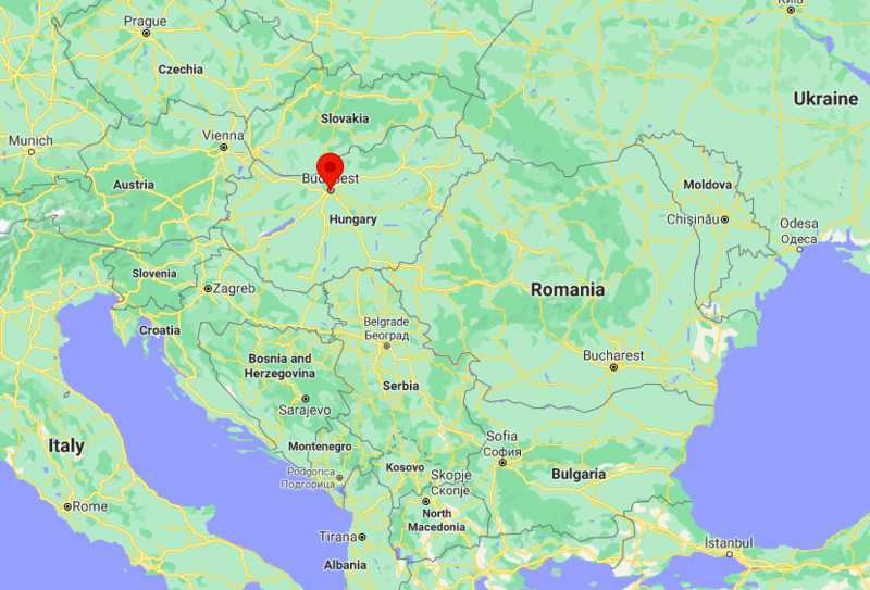
As shown in the given Budapest location map that Hungary is located on the Danube River in central-north of Hungary. Budapest is the largest and capital city of Hungary.
Location Map of Budapest, Hungary
 About Map: The map showing location of Budapest in Hungary.
Where is Budapest Located
Budapest, capital and largest city of Hungary, and seat of Pest megye county. Budapest lies in Central Hungary, surrounded by settlements of the agglomeration in Pest county. By virtue of being a major city, Budapest is the center of political, industrial, commercial, transportation, and cultural activities.
It has some of the significant sites those are listed as World Heritage Site including the Buda Castle Quarter, Heroes' Square, Andrássy Avenue, and the Millennium Underground Railway, the second oldest in the world. Some other surprising attractions are second largest synagogue, third largest Parliament building, about 80 geothermal springs, and the world's largest thermal water cave system.
Interestingly, it has several sobriquets more popular of them are Heart of Europe, Pearl of Danube, Capital City of Spas and Termal Baths, Capital city of Freedom, Capital City of Festivals, and City of the Lights.
Moreover, Budapest is the centre of services including financial counseling, money transactions, commercial, and estate services. In addition, Tourism is also worth to be mentioned that fascinates thousands of tourists every year.
| City | Distance | City | Distance |
|---|---|---|---|
| Distance from Budapest to Prague | 443 kilometres (275 mi) | Distance from Budapest to Moscow | 1,565 kilometres (972 mi) |
| Distance from Budapest to Milan | 788 kilometres (490 mi) | Distance from Budapest to Warsaw | 545 kilometres (339 mi) |
| Distance from Budapest to Athens | 1,122 kilometres (697 mi) | Distance from Budapest to Vienna | 216 kilometres (134 mi) |
Budapest City, Hungary Facts & Informatiomn
| Continent | Europe |
| Country | Hungary |
| Region | Central Hungary |
| Location | Budapest lies in Central Hungary |
| Coordinates: | 47°29′33″N 19°03′05″E |
| Unification of Buda, Pest and Óbuda | 17 November 1873 |
| Boroughs | 23 Districts |
| Government | Mayor - Council |
| Area Capital city | 525.2 km2 (202.8 sq mi) |
| Urban Area | 2,538 km2 (980 sq mi) |
| Metro Area | 7,626 km2 (2,944 sq mi) |
| Elevation[3] | Highest (János Hill) 527 m (315 to 1,729 ft) Lowest (Danube) 96 m |
| Population (2021) | 1,771,865 |
| • Density | 3,388/km2 (8,770/sq mi) |
| Demonyms | Budapester, budapesti (Hungarian) |
| Time zone | UTC+1 (CET) | in Summer UTC+2 (CEST) |
| Postal code(s) | 1011-1239 |
| Area code | 1 |
| ISO 3166 code | HU-BU |
| NUTS code | HU101 |
| Airport | Budapest Ferenc Liszt International Airport (BUD) |
| Website | https://www.budapestinfo.hu/en/ |
- Where is Albania
- Where is Andorra
- Where is Austria
- Where is Belarus
- Where is Belgium
- Bosnia and Herzegovina
- Where is Bulgaria
- Where is Croatia
- Where is Cyprus
- Where is Czech Republic
- Where is Denmark
- Where is England
- Where is Estonia
- Where is Finland
- Where is France
- Where is Germany
- Where is Greece
- Where is Hungary
- Where is Iceland
- Where is Ireland
- Where is Italy
- Where is Latvia
- Where is Liechtenstein
- Where is Lithuania
- Where is Luxemburg
- Where is Malta
- Where is Moldova
- Where is Monaco
- Where is Montenegro
- Where is Netherlands
- Where is Northern Ireland
- Where is Norway
- Where is Poland
- Republic Of Macedonia
- Where is Romania
- Where is Russia
- Where is San Marino
- Where is Scotland
- Where is Serbia
- Where is Slovakia
- Where is Slovenia
- Where is Spain
- Where is Sweden
- Where is Switzerland
- Where is Turkey
- Where is Ukraine
- Where is UK
- Where is Wales
- Where is Amsterdam
- Where is Athens
- Where is Belfast
- Where is Berlin
- Where is Brussels
- Where is Bucharest
- Where is Budapest
- Where is Copenhagen
- Where is Edinburgh
- Where is Helsinki
- Where is Kiev
- Where is Lisbon
- Where is London
- Where is Madrid
- Where is Moscow
- Where is Oslo
- Where is Paris
- Where is Riga
- Where is Rome
- Where is Sofia
- Where is Stockholm
- Where is Vienna
- Where is Warsaw
