
Written and Fact-checked by Whereig Editors | Last Updated On: June 17, 2026
Where is Oslo Located on the Norway Map? Find Oslo’s location map, coordinates, population, nearby cities, attractions, roads and highways, climate, transportation, and important city facts.
Location Map of Oslo, Norway
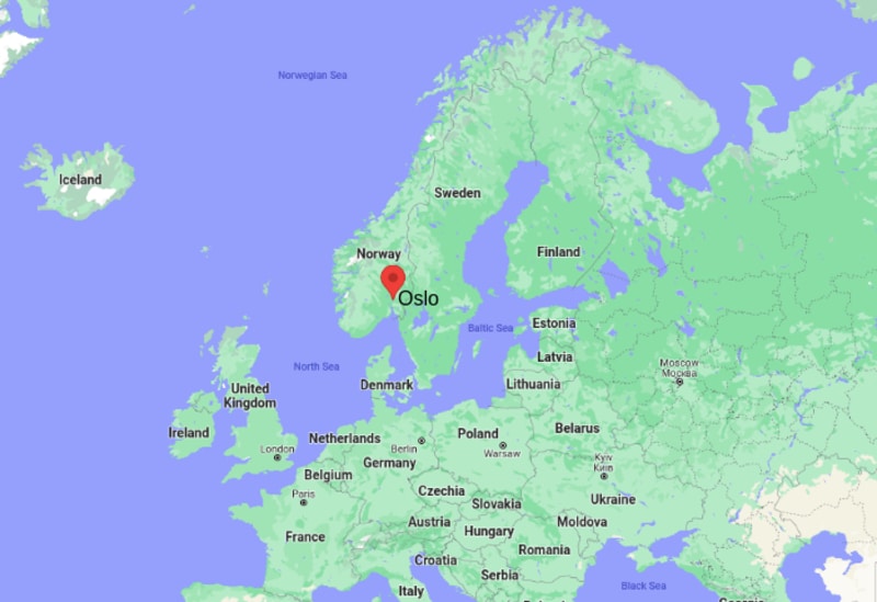
About Map: The map shows the location of Oslo in the Norway.
Where is Oslo Located?
Oslo is the largest and capital city of Norway. It was found a long back about 1048 by King Harald III; however, the city was almost abolished in by the year 1624. But by the year 1925, the city rebuilt again and likewise it took its modern shape.
Oslo is the most important political, scientific, cultural and commercial center of the country. In addition, the Oslo is also the important center of Norwegian trade, industries, banking, and shipping.
As per the study done by the Globalization and World Cities Study Group and Network in the year 2008, Oslo is the global city and listed as 'Beta World City'. Furthermore, Oslo's cityscape is being redeveloped as a modern city. It has all modern facilities including various access-points, an extensive Metro-system, and financial districts. Oslo's architecture is very diverse and example of model designs; it is attractive enough to fascinate anyone. Besides, Oslo has many parks and green areas that keep city pollution free and green.
Oslo, Oslo County Quick Facts
| Fact | Details |
|---|---|
| City | Oslo |
| County | Oslo |
| Country | Norway |
| National Capital | Oslo |
| Region | Eastern Norway |
| Latitude | 59.9139° N |
| Longitude | 10.7522° E |
| Elevation | 75 ft (23 m) |
| Land Area | 175 sq mi |
| Water Area | Includes Oslofjord, lakes and rivers |
| Total Area | 175 sq mi |
| Population (Latest Estimate) | Approximately 720,000 |
| Population Density | Approximately 4,100 per sq mi |
| Postal Codes | 0001-1299 |
| Area Code | +47 |
| Time Zone Standard | Central European Time (UTC+1) |
| Time Zone Daylight | Central European Summer Time (UTC+2) |
| Currency | Norwegian Krone (NOK) |
| Administrative Code | Oslo Municipality |
| National Representation | Norwegian Parliament Constituencies |
Nearby Cities to Oslo, Norway
- Bærum, Norway - 7 mi West
- Lillestrøm, Norway - 11 mi Northeast
- Asker, Norway - 15 mi Southwest
- Nesoddtangen, Norway - 10 mi South
- Drøbak, Norway - 22 mi South
- Drammen, Norway - 27 mi Southwest
- Moss, Norway - 38 mi South
- Hønefoss, Norway - 40 mi Northwest
- Fredrikstad, Norway - 57 mi South
- Sarpsborg, Norway - 58 mi Southeast
Oslo, Norway Climate and Weather Overview
| Month | Avg High (°F) | Avg Low (°F) | Avg Rainfall (in) |
|---|---|---|---|
| January | 32 | 21 | 1.9 |
| April | 52 | 34 | 1.6 |
| July | 74 | 55 | 3.1 |
| October | 52 | 41 | 3.2 |
| Annual | 53 | 39 | 30.0 |
| Climate Attribute | Details |
|---|---|
| Climate Classification (Köppen) | Dfb - Humid Continental |
| Annual Rainfall | Approximately 30 inches |
| Annual Sunshine Days | Approximately 1,650 sunshine hours |
| Hurricane/Tornado Risk | Very Low |
| Snowfall | Regular winter snowfall |
Driving Distances from Oslo, Norway
| City | County | Distance (mi) | Approx. Drive Time |
|---|---|---|---|
| Bærum | Akershus | 7 | 15 min |
| Lillestrøm | Akershus | 11 | 20 min |
| Asker | Akershus | 15 | 25 min |
| Nesoddtangen | Akershus | 10 | 25 min |
| Drøbak | Akershus | 22 | 35 min |
| Drammen | Buskerud | 27 | 40 min |
| Moss | Østfold | 38 | 50 min |
| Hønefoss | Buskerud | 40 | 55 min |
| Fredrikstad | Østfold | 57 | 1 hr 10 min |
| Sarpsborg | Østfold | 58 | 1 hr 10 min |
Transportation and Connectivity in Oslo, Norway
| Airport Name | Oslo Airport |
| IATA Code | OSL |
| Port | Port of Oslo |
| Major Highways | E6, E18, Ring 3, Ring 2 |
| Train Service | Vy Rail, Flytoget Airport Express and Regional Rail |
| Local Transit Service | Oslo Metro, Trams, Buses and Ferries |
- E6 - Norway's primary north-south highway connecting Oslo with Trondheim and the Swedish border.
- E18 - Major route linking Oslo with southern Norway and Sweden.
- Ring 3 - Main urban ring road serving metropolitan traffic.
- Ring 2 - Connects central districts and major business areas.
- Airport Express Train - Fast connection between Oslo Central Station and Oslo Airport.
Key Landmarks and Places to Visit in Oslo, Norway
| Landmark Name | Type |
|---|---|
| Oslo Opera House | Cultural Landmark |
| Akershus Fortress | Historic Fortress |
| Vigeland Park | Sculpture Park |
| The Royal Palace | Historic Palace |
| MUNCH Museum | Art Museum |
| Fram Museum | Museum |
| Norwegian Folk Museum | Open-Air Museum |
| Holmenkollen Ski Jump | Sports Landmark |
| Oslo City Hall | Government Building |
| Aker Brygge | Waterfront District |
Places to Visit in Oslo, Norway
| Landmark Name | Type |
|---|---|
| Oslo Opera House | Cultural Landmark |
| Akershus Fortress | Historic Fortress |
| Vigeland Park | Sculpture Park |
| The Royal Palace | Historic Palace |
| MUNCH Museum | Art Museum |
| Fram Museum | Museum |
| Norwegian Folk Museum | Open-Air Museum |
| Holmenkollen Ski Jump | Sports Landmark |
| Oslo City Hall | Government Building |
| Aker Brygge | Waterfront District |
Colleges and Universities in Oslo, Norway
| Institution Name | Type | Level | Notable For |
|---|---|---|---|
| University of Oslo | Public | University | Research excellence |
| BI Norwegian Business School | Private | University | Business education |
| Oslo Metropolitan University | Public | University | Professional studies |
| Norwegian School of Sport Sciences | Public | University | Sports science |
| Norwegian Academy of Music | Public | University | Music education |
Waterbodies in Oslo, Norway
Oslofjord, Akerselva River, Alna River, Maridalsvannet Lake, Sognsvann Lake, Bogstadvannet Lake, Bunnefjorden, Lysaker River, Nøklevann Lake, Sørenga Waterfront
Golf Courses in Oslo, Norway
Oslo Golf Club, Miklagard Golf, Losby Golf Club, Bærum Golfklubb, Grini Golf Club, Hauger Golfklubb, Romerike Golfklubb, Drøbak Golfklubb, Kjekstad Golfklubb, Østmarka Golfklubb
Oslo, Norway - Key Historical Facts
- Oslo was founded around 1040 and became an important medieval trading center in Scandinavia.
- The city was largely rebuilt after a devastating fire in 1624 under King Christian IV.
- Oslo served as the capital of Norway following the country's independence movement in the nineteenth century.
- The city was officially renamed from Kristiania back to Oslo in 1925.
- Oslo is home to the Nobel Peace Prize ceremony, held annually at Oslo City Hall.
- Today, Oslo is Norway's political, economic and cultural center and one of Europe's fastest-growing capitals.