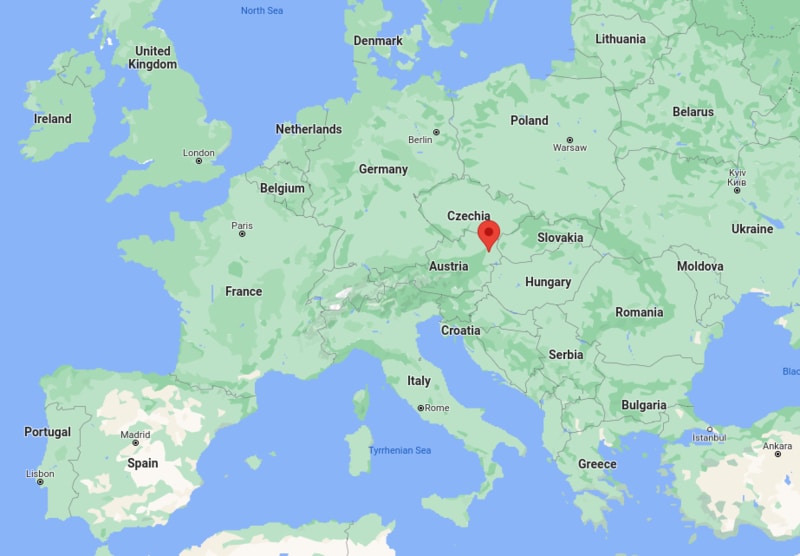
The given Vienna location map that Vienna is located in the north-east of Austria. Vienna is the national capital, largest city, and one of nine states of Austria.
Location Map of Vienna, Austria

Where is Vienna Located?
It is the political, economic, and cultural center of Austria. In the year 2001, the city centre was listed as UNESCO World Heritage Site. Above all, it hosts some of the important international organizations including United Nations and OPEC.
For the administrative purpose, Vienna is divided into 23 districts (Bezirke). The administrative district office in Vienna is known as Magistratisches Bezirksamt; it serves similar to those in the other states.
Besides, Vienna is also important tourist attractions including the imperial palaces of the Hofburg and Schönbrunn. It homes some of the world's oldest zoo, Tiergarten Schönbrunn and the Riesenrad in the Prater. It has Cultural highlights that include Burgtheater, the Wiener Staatsoper, the Lipizzaner horses at the spanische Hofreitschule and the Vienna Boys' Choir. Moreover, it has more than 100 art museums that fascinate millions of tourists every year.
Facts about Vienna City, Austria
| Continent | Europe |
| Country | Austria |
| State | Vienna |
| Location | North-east of Austria |
| Coordinates: | 48°12′N 16°22′E |
| Population | 2.6 million, 1st in Austria (6th in EU) |
| • Density | 4,326.1/km2 (11,205/sq mi) |
| Area of Capital city and state | 414.78 km2 (160.15 sq mi) |
| • Land | 395.25 km2 (152.61 sq mi) |
| • Water | 19.39 km2 (7.49 sq mi) |
| Elevation | 151 (Lobau) - 542 (Hermannskogel) m (495-1,778 ft) |
| Time zone | UTC+1 (CET), IN Summer DST - UTC+2 (CEST) |
| Postal code | 1xx0 (xx = district number), 1300 (airport), 1400 (United Nations), other 1yyy (postal boxes) |
| ISO 3166 code | AT-9 |
| Vehicle registration | W |
| Seats in the Federal Council | 11 / 61 |
| GeoTLD | .wien |
| Airport | Vienna International Airport, |
| Website | www.wien.gv.at |
Location Map of Austria Cities
- Where is Albania
- Where is Andorra
- Where is Austria
- Where is Belarus
- Where is Belgium
- Bosnia and Herzegovina
- Where is Bulgaria
- Where is Croatia
- Where is Cyprus
- Where is Czech Republic
- Where is Denmark
- Where is England
- Where is Estonia
- Where is Finland
- Where is France
- Where is Germany
- Where is Greece
- Where is Hungary
- Where is Iceland
- Where is Ireland
- Where is Italy
- Where is Latvia
- Where is Liechtenstein
- Where is Lithuania
- Where is Luxemburg
- Where is Malta
- Where is Moldova
- Where is Monaco
- Where is Montenegro
- Where is Netherlands
- Where is Northern Ireland
- Where is Norway
- Where is Poland
- Republic Of Macedonia
- Where is Romania
- Where is Russia
- Where is San Marino
- Where is Scotland
- Where is Serbia
- Where is Slovakia
- Where is Slovenia
- Where is Spain
- Where is Sweden
- Where is Switzerland
- Where is Turkey
- Where is Ukraine
- Where is UK
- Where is Wales
- Where is Amsterdam
- Where is Athens
- Where is Belfast
- Where is Berlin
- Where is Brussels
- Where is Bucharest
- Where is Budapest
- Where is Copenhagen
- Where is Edinburgh
- Where is Helsinki
- Where is Kiev
- Where is Lisbon
- Where is London
- Where is Madrid
- Where is Moscow
- Where is Oslo
- Where is Paris
- Where is Riga
- Where is Rome
- Where is Sofia
- Where is Stockholm
- Where is Vienna
- Where is Warsaw
