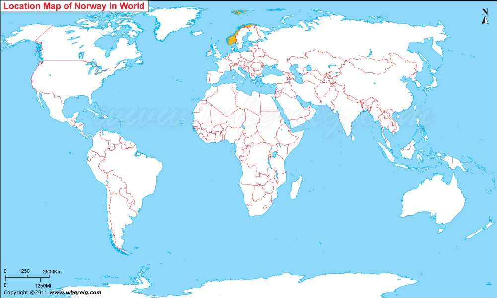
Where is Norway Located?
The given Norway location map shows that Norway is located in the north-west of Europe continent. Norway map also shows that it is the western part of the Scandinavian Peninsula. Apart from the mainland, it has two bigger islands (group) in the North Atlantic Ocean i.e. Svalbard and Bouvet Island and Jan Mayen Island.
Norway shares its international boundaries with Sweden in the east and Finland and Russia in the north-east. However, in the east it makes coastline with Norwegian Sea and in the south Skagerrak Strait separates Norway from Denmark. The capital city of the country is Oslo. The government type of Norway is parliamentary democracy and constitutional monarchy, with King Harald V as its head of state. Norway is a member of the United Nations, NATO, the Nordic Council, the Council of Europe, and is a member of the European Economic Area, the WTO, and the OECD.
In terms of Monetary Value, today, Norway ranks as the second wealthiest country in the world. Besides, Norway economy is largely depends upon the presence of extensive reserves of petroleum, natural gas, minerals, seafood, forests, fresh water, and hydropower. Outside the Middle East region, Norway is the world's largest producer of oil and natural gas per capita.
Due to its geographical position and latitudinal extension, there are large seasonal variations in daylight. The length of day and night also varies according to the season.
Counties of Norway
| County | Administrative Center | Population | Area | Latitude and Longitude |
|---|---|---|---|---|
| Oslo | Oslo | 720,000+ | 454 sq km (175 sq mi) | 59.9139° N, 10.7522° E |
| Viken | Drammen | 1.3 million+ | 24,592 sq km (9,495 sq mi) | 59.7439° N, 10.2045° E |
| Vestland | Bergen | 650,000+ | 33,868 sq km (13,077 sq mi) | 60.3913° N, 5.3221° E |
| Rogaland | Stavanger | 500,000+ | 9,377 sq km (3,620 sq mi) | 58.9690° N, 5.7331° E |
| Trøndelag | Trondheim | 480,000+ | 42,202 sq km (16,294 sq mi) | 63.4305° N, 10.3951° E |
| Nordland | Bodø | 240,000+ | 38,482 sq km (14,858 sq mi) | 67.2804° N, 14.4049° E |
| Innlandet | Hamar | 370,000+ | 52,113 sq km (20,121 sq mi) | 60.7945° N, 11.0679° E |
| Troms og Finnmark | Tromsø | 240,000+ | 74,831 sq km (28,892 sq mi) | 69.6492° N, 18.9553° E |
| Agder | Kristiansand | 320,000+ | 16,434 sq km (6,345 sq mi) | 58.1467° N, 7.9956° E |
| Møre og Romsdal | Molde | 270,000+ | 14,356 sq km (5,543 sq mi) | 62.7375° N, 7.1607° E |
10 Largest Cities in Norway
| City | County | Population | Latitude and Longitude |
|---|---|---|---|
| Oslo | Oslo | 720,000+ | 59.9139° N, 10.7522° E |
| Bergen | Vestland | 290,000+ | 60.3913° N, 5.3221° E |
| Trondheim | Trøndelag | 210,000+ | 63.4305° N, 10.3951° E |
| Stavanger | Rogaland | 145,000+ | 58.9690° N, 5.7331° E |
| Drammen | Viken | 110,000+ | 59.7439° N, 10.2045° E |
| Fredrikstad | Viken | 85,000+ | 59.2181° N, 10.9298° E |
| Kristiansand | Agder | 115,000+ | 58.1467° N, 7.9956° E |
| Tromsø | Troms og Finnmark | 78,000+ | 69.6492° N, 18.9553° E |
| Sandnes | Rogaland | 82,000+ | 58.8524° N, 5.7352° E |
| Ålesund | Møre og Romsdal | 67,000+ | 62.4722° N, 6.1549° E |
Top Tourist Attractions and Famous Places to Visit in Norway
- Geirangerfjord - Møre og Romsdal
- Northern Lights - Tromsø Region
- Bryggen Wharf - Bergen
- Pulpit Rock (Preikestolen) - Rogaland
- Lofoten Islands - Nordland
- Vigeland Sculpture Park - Oslo
- Flåm Railway - Vestland
- Trolltunga Cliff - Vestland
- Atlantic Ocean Road - Møre og Romsdal
- Jotunheimen National Park - Innlandet
- Oslo Opera House - Oslo
- Svalbard Arctic Wilderness - Svalbard
- North Cape - Troms og Finnmark
- Nærøyfjord - Vestland
- Akershus Fortress - Oslo
- Hardangerfjord - Vestland
Norway Facts
| Continent | Europe |
| Country | Norway |
| Official Name | Kingdom of Norway |
| Capital | Oslo |
| Largest City | Oslo |
| Coordinates | 60.4720° N, 8.4689° E |
| Administrative Divisions | 11 Counties |
| Official Languages | Norwegian |
| Demonym | Norwegian |
| Government | Unitary Parliamentary Constitutional Monarchy |
| Independence | 1905 |
| Total Area | 385,207 sq km (148,729 sq mi) |
| Population | 5.6 million+ (2025 est.) |
| Population Density | 15 people per sq km |
| Currency | Norwegian Krone (NOK) |
| GDP Nominal | Approx. USD 550 billion |
| Economy | Advanced High-Income Mixed Economy |
| Postal Code Format | #### |
| Country Calling Code | +47 |
| Time Zone | CET (UTC+1) |
| Internet TLD | .no |
| ISO Country Code | NO |
| Driving Side | Right |
| Major Cities | Oslo, Bergen, Trondheim, Stavanger, Kristiansand |
| Major Airports | Oslo Airport, Bergen Airport, Stavanger Airport |
| Highest Point | Galdhøpiggen (2,469 m) |
| Longest River | Glomma River |
| Climate | Subarctic and Oceanic Climate |
| Average Summer Temperature | 15°C to 25°C |
| Average Winter Temperature | -15°C to 5°C |
| Famous For | Fjords, Northern Lights, Vikings, Mountains, Arctic Landscapes |
| National Animal | Lion |
| National Sport | Cross-Country Skiing |
| National Dish | Fårikål |
| Official Website | regjeringen.no |
Major Rivers in Norway
- Glomma River
- Lågen River
- Tana River
- Drammenselva River
- Numedalslågen River
- Altaelva River
Norway Climate Facts
| Climate Type | Oceanic, Subarctic, and Arctic |
| Summer Temperature | 15°C to 25°C |
| Winter Temperature | -15°C to 5°C |
| Average Rainfall | 400 mm to 3,000 mm annually depending on region |
Neighboring Countries of Norway
- Sweden - East
- Finland - Northeast
- Russia - Northeast
References
- Official Government Website
- Statistics Norway
- World Bank
- CIA World Factbook
- United Nations Population Division
European Countries Location Maps
- Where is Albania
- Where is Andorra
- Where is Austria
- Where is Belarus
- Where is Belgium
- Bosnia and Herzegovina
- Where is Bulgaria
- Where is Croatia
- Where is Cyprus
- Where is Czech Republic
- Where is Denmark
- Where is England
- Where is Estonia
- Where is Finland
- Where is France
- Where is Germany