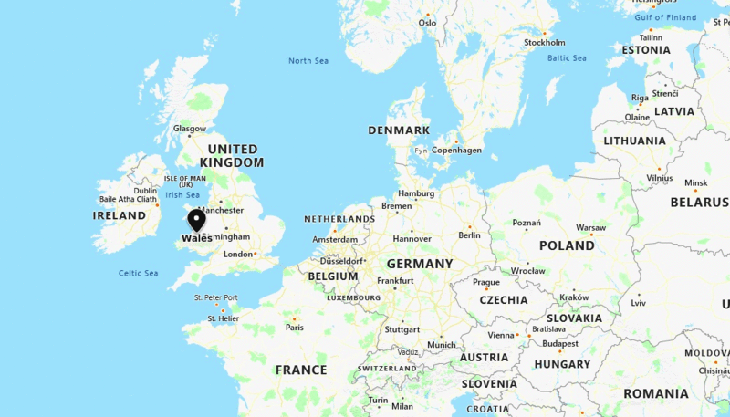
Wales is a country part of the United Kingdom and the island of Great Britain, bordered by England to its east and the Atlantic Ocean and Irish Sea to its west.
Location Map of Wales, UK

| Where is London | Where is Scotland | Where is England | Where is Northern Ireland |
| Where is Great Britain | London Map | Where is UK | Where is Isle of Man |
Where is Wales Located?
Wales is a country part of the United Kingdom and the island of Great Britain, bordered by England to its east and the Atlantic Ocean and Irish Sea to its north and west, the Bristol Channel to its south and Celtic Sea to its southwest. It covers total area of 20,779 km2 (8,023 sq mi) with a population of 2.5 million.
Cardiff is the capital city of Wales, located in south Wales, it is the eleventh-largest city in the United Kingdom.
Cities in Wales
| City | Year confirmed | Population |
|---|---|---|
| Cardiff | 1905 | 362,750 |
| Swansea | 1969 | 245,480 |
| Newport | 2002 | 151,500 |
| Wrexham | 2022 | 65,359 |
| Bangor | 1974 | 18,000 |
| St Asaph | 2012 | 3,500 |
| St Davids | 1994 | 1,840 |
Wales Facts
| Country Name | Wales |
| Part of | United Kingdom |
| Location | North-west Europe |
| Capital City | Cardiff |
| Largest City | Cardiff |
| Government | Devolved Parliamentary Government |
| Official Languages | English, Welsh |
| Currency | Pound Sterling (GBP) |
| Population | around 3.1 million (approx.) |
| Area | 20,779 sq km (8,023 sq mi) |
| Calling code | +44 |
| Climate | Temperate Maritime climate |
| Time zone | GMT (UTC±0), UTC+1 in Summer |
| Bordering Countries | England |
| Bordering Seas | Irish Sea, Celtic Sea, Bristol Channel |
| National Animal | Red Dragon (symbol) |
| National Flower | Daffodil |
| National Emblem | Leek |
| National Anthem | Hen Wlad Fy Nhadau (Land of My Fathers) |
| Flag Name | Red Dragon (Y Ddraig Goch) |
| Highest Point | Snowdon – 1,085 m (Snowdonia National Park) |
| Major Rivers | River Taff, River Severn, River Dee |
| Major Cities | Cardiff, Swansea, Newport, Wrexham |
| Famous For | Castles, mountains, rugby, Welsh culture and language |
| Rail Network | Transport for Wales, Great Western Railway |
| Major Airports | Cardiff Airport (CWL) |
| Internet TLD | .uk (also .wales) |
| Official Website | www.gov.wales |
Places to Visit in Wales
| Snowdonia National Park | Isle of Anglesey | Conwy | Pembrokeshire Coast |
| Llangollen | Brecon Beacons National Park | Portmeirion | St. Davids |
| Pontcysyllte Aqueduct | Cardiff - Capital City | Anglesey | North Wales |
| Tenbey | Swansea | Brecon | Gower |
| Rhossili | Barmouth | Newport | Holyhead |
Location Map of UK Cities
- Where is Aberdeen
- Where is Basildon
- Where is Basingstoke
- Where is Bath
- Where is Bedford
- Where is Birkenhead
- Where is Blackburn
- Where is Blackpool
- Where is Bolton
- Where is Bournemouth
- Where is Bradford
- Where is Brighton
- Where is Bristol
- Where is Cambridge
- Where is Cardiff
- Where is Chelmsford
- Where is Cheltenham
- Where is Chester
- Where is Colchester
- Where is Coventry
- Where is Crawley
- Where is Darlington
- Where is Dudley
- Where is Dundee
- Where is Eastbourne
- Where is Edinburgh
- Where is Exeter
- Where is Gateshead
- Where is Gillingham
- Where is Gloucester
- Where is Halifax
- Where is Harlow
- Where is Harrogate
- Where is Hartlepool
- Where is Hastings
- Where is Hemel Hempstead
- Where is High Wycombe
- Where is Huddersfield
- Where is Ipswich
- Where is Kingston Upon Hull
- Where is Leeds
- Where is Leicester
- Where is Lincoln
- Where is Lisburn
- Where is Liverpool
- Where is Londonderry
- Where is Luton
- Where is Maidstone
- Where is Middlesbrough
- Where is Milton Keynes
- Where is Newcastle Upon Tyne
- Where is Newport
- Where is Northampton
- Where is Norwich
- Where is Nottingham
- Where is Oldham
- Where is Oxford
- Where is Peterborough
- Where is Plymouth
- Where is Poole
- Where is Portsmouth
- Where is Preston
- Where is Reading
- Where is Rochdale
- Where is Rotherham
- Where is Saint Albans
- Where is Saint Helens
- Where is Sheffield
- Where is Slough
- Where is Solihull
- Where is South Shields
- Where is Southampton
- Where is Southend On Sea
- Where is Southport
- Where is Stevenage
- Where is Stockport
- Where is Stockton On Tees
- Where is Stoke On Trent
- Where is Sunderland
- Where is Sutton Coldfield
- Where is Swansea
- Where is Swindon
- Where is Ukmerge
- Where is Wakefield
- Where is Walsall
- Where is Warrington
- Where is Watford
- Where is West Bromwich
- Where is Weston Super Mare
- Where is Wigan
- Where is Woking
- Where is Wolverhampton
- Where is Worcester
- Where is Worthing
