
The given the Netherlands location map shows that the Netherlands is located in the western part of Europe continent. It shares international boundaries with Germany in the east and Belgium in the south. However, in the west North Seas lies and separates it from UK.
Where is Netherlands Located in the World Map
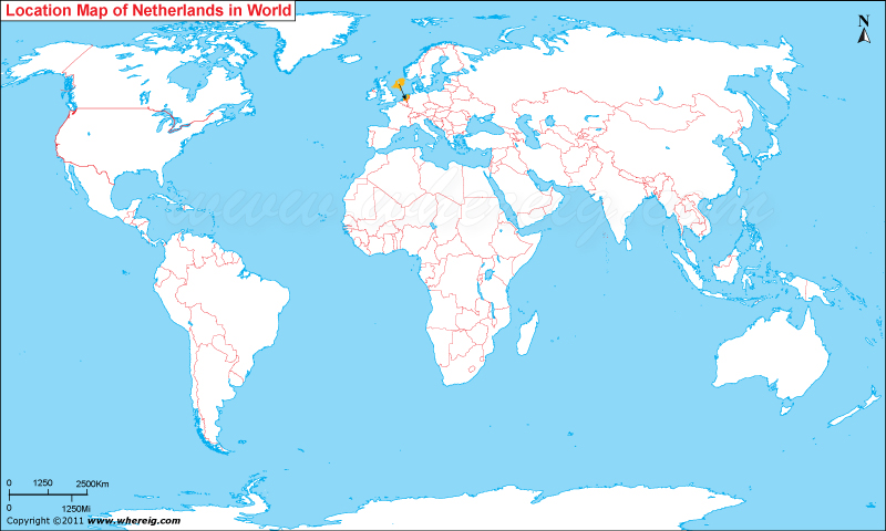
Where is Netherlands Located?
Netherlands, country located in northwestern Europe, also known as Holland. The Netherlands is bordered by the North Sea, Belgium to the south and Germany to the east. The government type of the Netherlands is parliamentary democratic constitutional monarchy. The capital city is Amsterdam; however, the seat of government is in The Hague. It is a member of the European Union, NATO, OECD, and WTO. Additionally, with Belgium and Luxembourg, it constitutes the Benelux economic union. The Netherlands more frequent referred as Holland and the term Dutch is used for the people and language of the Netherlands.
The country is politically quite significant because it houses the headquarters of some of the international organizations such as headquarters of five international courts: the Permanent Court of Arbitration, the International Court of Justice, the International Criminal Tribunal for the Former Yugoslavia, the International Criminal Court and the Special Tribunal for Lebanon and also the Organization for the Prohibition of Chemical Weapons. Most of them are located in the city Hague. Hence, The Hague is more popularly known as "the world's legal capital".
The climate type of the country is moderate maritime featured with cool summers and mild winters. Moreover, the economy of the Netherlands is quite strong and depends upon various resourceful sectors including shipping, fishing, trade, banking and major industries include chemicals, metallurgy, machinery, electrical, goods and tourism.
Capital of Netherlands
Amsterdam is the capital city and most populous city of the Kingdom of the Netherlands. The five largest cities in the Netherlands are Amsterdam, Rotterdam, The Hague, Utrecht and Eindhoven.Provinces of the Netherlands
| Province | Capital | Population | Area | Latitude and Longitude |
|---|---|---|---|---|
| North Holland | Haarlem | 2.9 million+ | 4,092 sq km (1,580 sq mi) | 52.3874° N, 4.6462° E |
| South Holland | The Hague | 3.8 million+ | 3,419 sq km (1,320 sq mi) | 52.0705° N, 4.3007° E |
| North Brabant | 's-Hertogenbosch | 2.6 million+ | 5,082 sq km (1,962 sq mi) | 51.6978° N, 5.3037° E |
| Gelderland | Arnhem | 2.1 million+ | 5,136 sq km (1,983 sq mi) | 51.9851° N, 5.8987° E |
| Utrecht | Utrecht | 1.4 million+ | 1,560 sq km (602 sq mi) | 52.0907° N, 5.1214° E |
| Limburg | Maastricht | 1.1 million+ | 2,209 sq km (853 sq mi) | 50.8514° N, 5.6900° E |
| Overijssel | Zwolle | 1.2 million+ | 3,421 sq km (1,321 sq mi) | 52.5168° N, 6.0830° E |
| Friesland | Leeuwarden | 650,000+ | 5,749 sq km (2,220 sq mi) | 53.2012° N, 5.7999° E |
| Groningen | Groningen | 590,000+ | 2,960 sq km (1,143 sq mi) | 53.2194° N, 6.5665° E |
| Zeeland | Middelburg | 390,000+ | 2,934 sq km (1,132 sq mi) | 51.4988° N, 3.6109° E |
10 Largest Cities in the Netherlands
| City | Province | Population | Latitude and Longitude |
|---|---|---|---|
| Amsterdam | North Holland | 930,000+ | 52.3676° N, 4.9041° E |
| Rotterdam | South Holland | 670,000+ | 51.9244° N, 4.4777° E |
| The Hague | South Holland | 560,000+ | 52.0705° N, 4.3007° E |
| Utrecht | Utrecht | 370,000+ | 52.0907° N, 5.1214° E |
| Eindhoven | North Brabant | 245,000+ | 51.4416° N, 5.4697° E |
| Tilburg | North Brabant | 225,000+ | 51.5555° N, 5.0913° E |
| Groningen | Groningen | 235,000+ | 53.2194° N, 6.5665° E |
| Almere | Flevoland | 220,000+ | 52.3508° N, 5.2647° E |
| Breda | North Brabant | 185,000+ | 51.5719° N, 4.7683° E |
| Nijmegen | Gelderland | 180,000+ | 51.8126° N, 5.8372° E |
Top Tourist Attractions and Famous Places to Visit in the Netherlands
- Rijksmuseum - Amsterdam
- Keukenhof Gardens - Lisse
- Zaanse Schans Windmills - North Holland
- Anne Frank House - Amsterdam
- Kinderdijk Windmills - South Holland
- Van Gogh Museum - Amsterdam
- Canals of Amsterdam - Amsterdam
- Efteling Theme Park - North Brabant
- Madurodam - The Hague
- Euromast Tower - Rotterdam
- Giethoorn Village - Overijssel
- Peace Palace - The Hague
- Delta Works - Zeeland
- Dom Tower - Utrecht
- Hoge Veluwe National Park - Gelderland
- Scheveningen Beach - South Holland
Netherlands Facts
| Continent | Europe |
| Country | Netherlands |
| Official Name | Kingdom of the Netherlands |
| Capital | Amsterdam |
| Largest City | Amsterdam |
| Coordinates | 52.1326° N, 5.2913° E |
| Administrative Divisions | 12 Provinces |
| Official Languages | Dutch |
| Demonym | Dutch |
| Government | Parliamentary Constitutional Monarchy |
| Independence | 1581 |
| Total Area | 41,865 sq km (16,164 sq mi) |
| Population | 18 million+ (2025 est.) |
| Population Density | 430 people per sq km |
| Currency | Euro (€) |
| GDP Nominal | Approx. USD 1.2 trillion |
| Economy | Advanced High-Income Economy |
| Postal Code Format | #### XX |
| Country Calling Code | +31 |
| Time Zone | CET (UTC+1) |
| Internet TLD | .nl |
| ISO Country Code | NL |
| Driving Side | Right |
| Major Cities | Amsterdam, Rotterdam, The Hague, Utrecht, Eindhoven |
| Major Airports | Amsterdam Schiphol Airport, Rotterdam The Hague Airport, Eindhoven Airport |
| Highest Point | Vaalserberg (322 m) |
| Longest River | Rhine River |
| Climate | Temperate Maritime Climate |
| Average Summer Temperature | 17°C to 25°C |
| Average Winter Temperature | 0°C to 7°C |
| Famous For | Windmills, Tulips, Cycling, Canals, Art Museums |
| National Animal | Lion |
| National Sport | Football |
| National Dish | Stamppot |
| Official Website | government.nl |
Major Rivers in the Netherlands
- Rhine River
- Meuse River
- Waal River
- IJssel River
- Scheldt River
- Lek River
Netherlands Climate Facts
| Climate Type | Temperate Maritime |
| Summer Temperature | 17°C to 25°C |
| Winter Temperature | 0°C to 7°C |
| Average Rainfall | 700 mm to 900 mm annually |
Neighboring Countries of the Netherlands
- Germany - East
- Belgium - South
References
- Official Government Website
- Statistics Netherlands
- World Bank
- CIA World Factbook
- United Nations Population Division
- Where is Albania
- Where is Andorra
- Where is Austria
- Where is Belarus
- Where is Belgium
- Bosnia and Herzegovina
- Where is Bulgaria
- Where is Croatia
- Where is Cyprus
- Where is Czech Republic
- Where is Denmark
- Where is England
- Where is Estonia
- Where is Finland
- Where is France
- Where is Germany
- Where is Greece
- Where is Hungary
- Where is Iceland
- Where is Ireland
- Where is Italy
- Where is Latvia
- Where is Liechtenstein
- Where is Lithuania
- Where is Luxemburg
- Where is Malta
- Where is Moldova
- Where is Monaco
- Where is Montenegro
- Where is Netherlands
- Where is Northern Ireland
- Where is Norway
- Where is Poland
- Republic Of Macedonia
- Where is Romania
- Where is Russia
- Where is San Marino
- Where is Scotland
- Where is Serbia
- Where is Slovakia
- Where is Slovenia
- Where is Spain
- Where is Sweden
- Where is Switzerland
- Where is Turkey
- Where is Ukraine
- Where is UK
- Where is Wales
- Where is Amsterdam
- Where is Athens
- Where is Belfast
- Where is Berlin
- Where is Brussels
- Where is Bucharest
- Where is Budapest
- Where is Copenhagen
- Where is Edinburgh
- Where is Helsinki
- Where is Kiev
- Where is Lisbon
- Where is London
- Where is Madrid
- Where is Moscow
- Where is Oslo
- Where is Paris
- Where is Riga
- Where is Rome
- Where is Sofia
- Where is Stockholm
- Where is Vienna
- Where is Warsaw