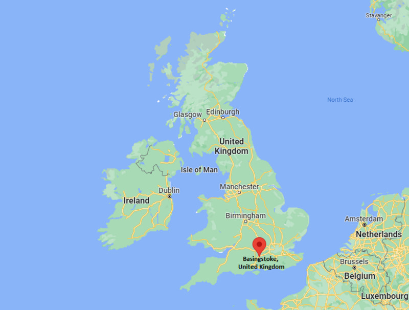
Basingstoke is a town in the county of Hampshire, England. It lies on the natural trade route between the southwest of England and London, It lies between latitudes 51.2666667 and longitudes -1.0833333.
Location Map of Basingstoke, England (UK)

Where is Basingstoke Located?
Basingstoke is the largest town in the county of Hampshire. It is located 20 miles (32 km) of Winchester, 27 miles (43 km) west of Guildford, 30 miles (48 km) northeast of Southampton and 48 miles (77 km) southwest of London. It is situated in south central England. It has population of 113,776.
| Where is England | Where is Scotland | Where is Wales |
| Where is Northern Ireland | Where is Great Britain | Where is London |
Basingstoke Town - Facts
| Sovereign state | United Kingdom |
| Country | England |
| District | Basingstoke and Deane |
| Shire county | Hampshire |
| Region | South East |
| Distance from London | 48 miles (77 km) |
| Continent | Europe |
| Coordinates: | 51.2667°N 1.0876°W |
| Post town | BASINGSTOKE |
| Postcode district | RG21-RG24 |
| Dialling code | 1256 |
| Population | 113,776 |
| Police | Hampshire |
| Fire | Hampshire |
| Ambulance | South Central |
| UK Parliament | Basingstoke |
| Basildon nearest airport | Southampton Airport (SOU) 24.6 miles London Heathrow Airport (LHR) 30.6 miles |
| Road | M3 motorway |
| Railway | Basingstoke railway station |
| Website | basildon.gov.uk |
Location Map of UK Cities
- Where is Aberdeen
- Where is Basildon
- Where is Basingstoke
- Where is Bath
- Where is Bedford
- Where is Birkenhead
- Where is Blackburn
- Where is Blackpool
- Where is Bolton
- Where is Bournemouth
- Where is Bradford
- Where is Brighton
- Where is Bristol
- Where is Cambridge
- Where is Cardiff
- Where is Chelmsford
- Where is Cheltenham
- Where is Chester
- Where is Colchester
- Where is Coventry
- Where is Crawley
- Where is Darlington
- Where is Dudley
- Where is Dundee
- Where is Eastbourne
- Where is Edinburgh
- Where is Exeter
- Where is Gateshead
- Where is Gillingham
- Where is Gloucester
- Where is Halifax
- Where is Harlow
- Where is Harrogate
- Where is Hartlepool
- Where is Hastings
- Where is Hemel Hempstead
- Where is High Wycombe
- Where is Huddersfield
- Where is Ipswich
- Where is Kingston Upon Hull
- Where is Leeds
- Where is Leicester
- Where is Lincoln
- Where is Lisburn
- Where is Liverpool
- Where is Londonderry
- Where is Luton
- Where is Maidstone
- Where is Middlesbrough
- Where is Milton Keynes
- Where is Newcastle Upon Tyne
- Where is Newport
- Where is Northampton
- Where is Norwich
- Where is Nottingham
- Where is Oldham
- Where is Oxford
- Where is Peterborough
- Where is Plymouth
- Where is Poole
- Where is Portsmouth
- Where is Preston
- Where is Reading
- Where is Rochdale
- Where is Rotherham
- Where is Saint Albans
- Where is Saint Helens
- Where is Sheffield
- Where is Slough
- Where is Solihull
- Where is South Shields
- Where is Southampton
- Where is Southend On Sea
- Where is Southport
- Where is Stevenage
- Where is Stockport
- Where is Stockton On Tees
- Where is Stoke On Trent
- Where is Sunderland
- Where is Sutton Coldfield
- Where is Swansea
- Where is Swindon
- Where is Ukmerge
- Where is Wakefield
- Where is Walsall
- Where is Warrington
- Where is Watford
- Where is West Bromwich
- Where is Weston Super Mare
- Where is Wigan
- Where is Woking
- Where is Wolverhampton
- Where is Worcester
- Where is Worthing
