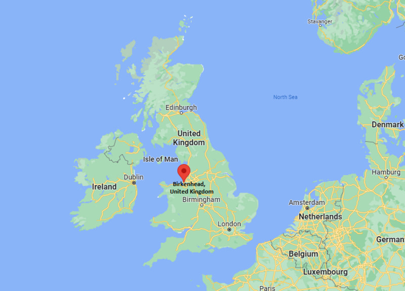
Birkenhead is a town within the Metropolitan Borough of Wirral in Merseyside, England and It is located 53.39 latitude and -3.01 longitude.
Location Map of Birkenhead, England (UK)

Where is Birkenhead Located?
Birkenhead is a town in the Metropolitan Borough of Wirral, Merseyside, England. It is situated on the Wirral Peninsula, along the south bank of the River Mersey, opposite the city of Liverpool. At the 2011 census, it had a population of 88,818.
| Where is England | Where is Scotland | Where is Wales |
| Where is Northern Ireland | Where is Great Britain | Where is London |
Birkenhead Town - Facts
| Sovereign state | United Kingdom |
| Country | England |
| Metropolitan borough | Wirral |
| Metropolitan county | Merseyside |
| Region | North West |
| Distance from London | 178 mi (286 km)[2] SE |
| Continent | Europe |
| Coordinates: | 51.38°N 2.36°W |
| ISO 3166 code | GB-WRL |
| Post town | BIRKENHEAD |
| Postcode district | CH41, CH42 |
| Dialling code | 151 |
| Population | 88,818 (2011 Census |
| Area | 25.18 km2 (9.72 sq mi) |
| OS grid reference | SJ324890 |
| Police | Merseyside |
| Fire | Merseyside |
| Ambulance | North West |
| UK Parliament | Birkenhead |
| Nearest airport | Liverpool John Lennon Airport - located about 8 miles (13 km) |
| Road | M53 motorway |
| Railway | Birkenhead Grange Lane railway station Birkenhead Dock railway station |
Location Map of UK Cities
- Where is Aberdeen
- Where is Basildon
- Where is Basingstoke
- Where is Bath
- Where is Bedford
- Where is Birkenhead
- Where is Blackburn
- Where is Blackpool
- Where is Bolton
- Where is Bournemouth
- Where is Bradford
- Where is Brighton
- Where is Bristol
- Where is Cambridge
- Where is Cardiff
- Where is Chelmsford
- Where is Cheltenham
- Where is Chester
- Where is Colchester
- Where is Coventry
- Where is Crawley
- Where is Darlington
- Where is Dudley
- Where is Dundee
- Where is Eastbourne
- Where is Edinburgh
- Where is Exeter
- Where is Gateshead
- Where is Gillingham
- Where is Gloucester
- Where is Halifax
- Where is Harlow
- Where is Harrogate
- Where is Hartlepool
- Where is Hastings
- Where is Hemel Hempstead
- Where is High Wycombe
- Where is Huddersfield
- Where is Ipswich
- Where is Kingston Upon Hull
- Where is Leeds
- Where is Leicester
- Where is Lincoln
- Where is Lisburn
- Where is Liverpool
- Where is Londonderry
- Where is Luton
- Where is Maidstone
- Where is Middlesbrough
- Where is Milton Keynes
- Where is Newcastle Upon Tyne
- Where is Newport
- Where is Northampton
- Where is Norwich
- Where is Nottingham
- Where is Oldham
- Where is Oxford
- Where is Peterborough
- Where is Plymouth
- Where is Poole
- Where is Portsmouth
- Where is Preston
- Where is Reading
- Where is Rochdale
- Where is Rotherham
- Where is Saint Albans
- Where is Saint Helens
- Where is Sheffield
- Where is Slough
- Where is Solihull
- Where is South Shields
- Where is Southampton
- Where is Southend On Sea
- Where is Southport
- Where is Stevenage
- Where is Stockport
- Where is Stockton On Tees
- Where is Stoke On Trent
- Where is Sunderland
- Where is Sutton Coldfield
- Where is Swansea
- Where is Swindon
- Where is Ukmerge
- Where is Wakefield
- Where is Walsall
- Where is Warrington
- Where is Watford
- Where is West Bromwich
- Where is Weston Super Mare
- Where is Wigan
- Where is Woking
- Where is Wolverhampton
- Where is Worcester
- Where is Worthing
