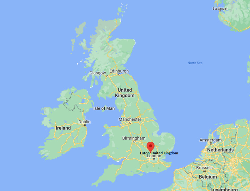
Where is Luton Located in the UK Map? Luton is a large town and local government district in the south-east of England, located 51 km (32 miles) north of London.
Location Map of Luton, England (UK)

Where is Luton Located?
Luton is a large town and local government district in the south-east of England, located 51 km (32 miles) north of London. It lies between latitudes 41.4901° N and longitudes 71.3128° W. Luton has a total area of 43.35 square miles, with a population of 213052 people.
Luton is a large town located in Bedfordshire, East England, UK. It lies about 50 km (31 miles) northwest of London and roughly 30 km (19 miles) east of Aylesbury.
The town is known for London Luton Airport, diverse culture, and strong transport links. You can easily reach Luton by train, bus, or car from London and nearby towns.
| Where is England | Where is Scotland | Where is Wales |
| Where is Northern Ireland | Where is Great Britain | Where is London |
Luton City Facts
| FACTS | Info |
|---|---|
| Sovereign State | United Kingdom |
| Country | England |
| Continent | Europe |
| Ceremonial county | Bedfordshire |
| Location | Luton is located in a break in the eastern part of the Chiltern Hills ; Bedfordshire |
| Coordinates | 51.8787° N, 0.4200° W |
| Area | 43.35 km2 |
| Popul |
- Where is Aberdeen
- Where is Basildon
- Where is Basingstoke
- Where is Bath
- Where is Bedford
- Where is Birkenhead
- Where is Blackburn
- Where is Blackpool
- Where is Bolton
- Where is Bournemouth
- Where is Bradford
- Where is Brighton
- Where is Bristol
- Where is Cambridge
- Where is Cardiff
- Where is Chelmsford
- Where is Cheltenham
- Where is Chester
- Where is Colchester
- Where is Coventry
- Where is Crawley
- Where is Darlington
- Where is Dudley
- Where is Dundee
- Where is Eastbourne
- Where is Edinburgh
- Where is Exeter
- Where is Gateshead
- Where is Gillingham
- Where is Gloucester
- Where is Halifax
- Where is Harlow
- Where is Harrogate
- Where is Hartlepool
- Where is Hastings
- Where is Hemel Hempstead
- Where is High Wycombe
- Where is Huddersfield
- Where is Ipswich
- Where is Kingston Upon Hull
- Where is Leeds
- Where is Leicester
- Where is Lincoln
- Where is Lisburn
- Where is Liverpool
- Where is Londonderry
- Where is Luton
- Where is Maidstone
- Where is Middlesbrough
- Where is Milton Keynes
- Where is Newcastle Upon Tyne
- Where is Newport
- Where is Northampton
- Where is Norwich
- Where is Nottingham
- Where is Oldham
- Where is Oxford
- Where is Peterborough
- Where is Plymouth
- Where is Poole
- Where is Portsmouth
- Where is Preston
- Where is Reading
- Where is Rochdale
- Where is Rotherham
- Where is Saint Albans
- Where is Saint Helens
- Where is Sheffield
- Where is Slough
- Where is Solihull
- Where is South Shields
- Where is Southampton
- Where is Southend On Sea
- Where is Southport
- Where is Stevenage
- Where is Stockport
- Where is Stockton On Tees
- Where is Stoke On Trent
- Where is Sunderland
- Where is Sutton Coldfield
- Where is Swansea
- Where is Swindon
- Where is Ukmerge
- Where is Wakefield
- Where is Walsall
- Where is Warrington
- Where is Watford
- Where is West Bromwich
- Where is Weston Super Mare
- Where is Wigan
- Where is Woking
- Where is Wolverhampton
- Where is Worcester
- Where is Worthing
