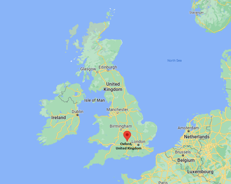
Where is Oxford Located in the UK Map? Oxford is a city in county of Oxfordshire, England. It is on the River Thames.
Location Map of Oxford, England (UK)

Where is Oxford Located?
Oxford is a city in county of Oxfordshire, England. It is on the River Thames. It lies between latitudes 51.4551° N and longitudes 0.9787° W. Oxford has a total area of 45.59 square miles, with a population of 151584 people.
| Where is England | Where is Scotland | Where is Wales |
| Where is Northern Ireland | Where is Great Britain | Where is London |
Oxford City Facts
| FACTS | Info |
|---|---|
| Sovereign State | United Kingdom |
| Country | England |
| Continent | Europe |
| Ceremonial county | Oxfordshire |
| Location | Central southern England |
| Coordinates | 51.7520° N, 1.2577° W |
| Area | 45.59 km2 |
| Population | 151,584 |
| Population Density | 3,270/km2 |
| Demonym(s) | Oxonian |
| Currency | Pound sterling (GBP) |
| Time zone | GMT (UTC 0) and BST (UTC+1) in summer |
| Country code | 44 |
| Postcode areas | OX |
| Postcode | OX1, OX2, OX3, OX4 |
| Dialling codes | 1865 |
| Climate | Temperate climate |
| Airport | Oxford Airport (OXF) |
| Nearest Airport | Oxford is Birmingham (BHX) |
| Official Website | www.oxford.gov.uk |
Location Map of UK Cities
- Where is Aberdeen
- Where is Basildon
- Where is Basingstoke
- Where is Bath
- Where is Bedford
- Where is Birkenhead
- Where is Blackburn
- Where is Blackpool
- Where is Bolton
- Where is Bournemouth
- Where is Bradford
- Where is Brighton
- Where is Bristol
- Where is Cambridge
- Where is Cardiff
- Where is Chelmsford
- Where is Cheltenham
- Where is Chester
- Where is Colchester
- Where is Coventry
- Where is Crawley
- Where is Darlington
- Where is Dudley
- Where is Dundee
- Where is Eastbourne
- Where is Edinburgh
- Where is Exeter
- Where is Gateshead
- Where is Gillingham
- Where is Gloucester
- Where is Halifax
- Where is Harlow
- Where is Harrogate
- Where is Hartlepool
- Where is Hastings
- Where is Hemel Hempstead
- Where is High Wycombe
- Where is Huddersfield
- Where is Ipswich
- Where is Kingston Upon Hull
- Where is Leeds
- Where is Leicester
- Where is Lincoln
- Where is Lisburn
- Where is Liverpool
- Where is Londonderry
- Where is Luton
- Where is Maidstone
- Where is Middlesbrough
- Where is Milton Keynes
- Where is Newcastle Upon Tyne
- Where is Newport
- Where is Northampton
- Where is Norwich
- Where is Nottingham
- Where is Oldham
- Where is Oxford
- Where is Peterborough
- Where is Plymouth
- Where is Poole
- Where is Portsmouth
- Where is Preston
- Where is Reading
- Where is Rochdale
- Where is Rotherham
- Where is Saint Albans
- Where is Saint Helens
- Where is Sheffield
- Where is Slough
- Where is Solihull
- Where is South Shields
- Where is Southampton
- Where is Southend On Sea
- Where is Southport
- Where is Stevenage
- Where is Stockport
- Where is Stockton On Tees
- Where is Stoke On Trent
- Where is Sunderland
- Where is Sutton Coldfield
- Where is Swansea
- Where is Swindon
- Where is Ukmerge
- Where is Wakefield
- Where is Walsall
- Where is Warrington
- Where is Watford
- Where is West Bromwich
- Where is Weston Super Mare
- Where is Wigan
- Where is Woking
- Where is Wolverhampton
- Where is Worcester
- Where is Worthing
