Written and Fact-checked by Whereig Editors | Last Updated On: June 18, 2026
Khartoum is the capital city of Sudan, located in Khartoum State where the Blue Nile and White Nile rivers meet. Situated at approximately 15.5007° N latitude and 32.5599° E longitude, the city covers about 1,010 sq km (390 sq mi) and has an estimated population of around 6.3 million people.
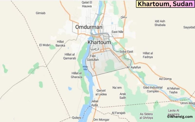
Location Map of Khartoum, Sudan
About Map: The map shows the location of Khartoum in the Sudan.
Where is Khartoum Located?
The place where the two Niles i.e. White Nile and Blue Nile meet is more popularly known as "al-Mogran".
Khartoum is the capital city of Sudan. The climate type of Khartoum is arid; however, city is appreciably developed and city has the highest concentration of economy in the country. The center of the city is well-planned; the trees are planted along the road of the city. The important industries of the city are glass manufacturing, food processing, printing, and textiles. Additionally, Petroleum products are now produced in the far north of the state Khartoum, which provides fuel and jobs to the city people.
Khartoum, Khartoum State Quick Facts
Fact
Details
City
Khartoum
State
Khartoum State
Country
Sudan
National Capital
Khartoum
Region
Central Sudan
Latitude
15.5007° N
Longitude
32.5599° E
Elevation
1,257 ft (383 m)
Land Area
8.7 sq mi
Water Area
Includes the confluence of the Blue Nile and White Nile
Total Area
8.7 sq mi
Population (Latest Estimate)
Approximately 6.3 million (metro area)
Population Density
Approximately 725,000 per sq mi (city core)
Postal Codes
11111 and surrounding districts
Area Code
+249 183
Time Zone Standard
Central Africa Time (UTC+2)
Time Zone Daylight
No daylight saving time observed
Currency
Sudanese Pound (SDG)
Administrative Code
Khartoum State Administration
National Representation
National Legislative Constituencies
Nearby Cities to Khartoum, Sudan
Omdurman, Sudan - 4 mi West
Khartoum North (Bahri), Sudan - 5 mi North
Jebel Aulia, Sudan - 28 mi South
Halfaya, Sudan - 9 mi North
Shendi, Sudan - 93 mi Northeast
Wad Madani, Sudan - 114 mi Southeast
Atbara, Sudan - 193 mi Northeast
El Obeid, Sudan - 225 mi Southwest
Kosti, Sudan - 198 mi South
Dongola, Sudan - 330 mi North
Khartoum, Sudan Climate and Weather Overview
Month
Avg High (°F)
Avg Low (°F)
Avg Rainfall (in)
January
89
59
0.0
April
104
76
0.0
July
102
79
2.2
October
101
75
0.2
Annual
99
73
6.0
Climate Attribute
Details
Climate Classification (Köppen)
BWh - Hot Desert
Annual Rainfall
Approximately 6 inches
Annual Sunshine Days
More than 350 sunny days
Hurricane/Tornado Risk
Very Low
Snowfall
No snowfall
Driving Distances from Khartoum, Sudan
City
State/Region
Distance (mi)
Approx. Drive Time
Omdurman
Khartoum State
4
15 min
Khartoum North (Bahri)
Khartoum State
5
15 min
Halfaya
Khartoum State
9
20 min
Jebel Aulia
Khartoum State
28
40 min
Shendi
River Nile State
93
1 hr 40 min
Wad Madani
Al Jazirah State
114
2 hr
Kosti
White Nile State
198
3 hr
Atbara
River Nile State
193
3 hr
El Obeid
North Kordofan
225
4 hr
Dongola
Northern State
330
5 hr 30 min
Transportation and Connectivity in Khartoum, Sudan
Airport Name
Khartoum International Airport
IATA Code
KRT
Port
River Port on the Nile
Major Highways
Khartoum-Port Sudan Highway, Nile Street, Africa Road
Train Service
Sudan Railways Connections
Local Transit Service
Buses, Shared Taxis and Minibuses
Khartoum-Port Sudan Highway - Main route connecting the capital with Sudan's primary seaport.
Nile Street - Major riverside avenue serving government and commercial districts.
Africa Road - Important corridor linking southern and eastern parts of the city.
White Nile Bridge - Key crossing between Khartoum and Omdurman.
Blue Nile Bridge - Important connection between Khartoum and Bahri.
Key Landmarks and Places to Visit in Khartoum, Sudan
Landmark Name
Type
National Museum of Sudan
Museum
Confluence of the Blue and White Nile
Natural Landmark
Presidential Palace Museum
Historic Museum
Tuti Island
River Island
Al Mogran Family Park
Urban Park
Corinthia Hotel Tower
Architectural Landmark
Omdurman Souq
Traditional Market
Khalifa House Museum
Historic Site
Nile Street Waterfront
Riverfront Area
Khartoum War Cemetery
Historic Site
Places to Visit in Khartoum, Sudan
Landmark Name
Type
National Museum of Sudan
Museum
Confluence of the Blue and White Nile
Natural Landmark
Presidential Palace Museum
Historic Museum
Tuti Island
River Island
Al Mogran Family Park
Urban Park
Corinthia Hotel Tower
Architectural Landmark
Omdurman Souq
Traditional Market
Khalifa House Museum
Historic Site
Nile Street Waterfront
Riverfront Area
Khartoum War Cemetery
Historic Site
Colleges and Universities in Khartoum, Sudan
Institution Name
Type
Level
Notable For
University of Khartoum
Public
University
Research and higher education
Sudan University of Science and Technology
Public
University
Engineering and technology
Al Neelain University
Public
University
Medicine and sciences
Future University
Private
University
Business and IT
International University of Africa
Private
University
International studies
Waterbodies in Khartoum, Sudan
Blue Nile, White Nile, Nile River, Tuti Island Channels, Jebel Aulia Reservoir, Al Mogran Waters, Bahri Riverfront, Omdurman Nile Waterfront, Soba Waterways, Nile Confluence Basin
Golf Courses in Khartoum, Sudan
Khartoum Golf Club, Sudan Golf Club, Khartoum Sports City Golf Practice Area, Tuti Island Recreation Golf Grounds, Nile View Golf Facility
Khartoum, Sudan - Key Historical Facts
Khartoum was founded in 1821 as an Egyptian military outpost near the meeting point of the Blue and White Nile rivers.
The city became an important administrative and trading center during the nineteenth century.
Khartoum gained international attention during the Siege of Khartoum in 1884-1885.
After the Anglo-Egyptian reconquest, the city was rebuilt and developed as Sudan's administrative capital.
Khartoum became the capital of independent Sudan in 1956.
Its strategic location at the Nile confluence continues to make it the political and economic center of Sudan.