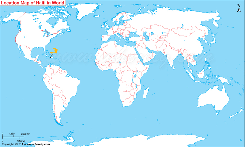
Haiti location depicts the Haiti is an island country located in the Caribbean Sea where it is part of Greater Antillean archipelago. It is lies between latitudes 19.0° North and longitudes 72.25° West. It is situated to the east of Cuba and Jamaica, The Bahamas, and the Turks and Caicos Islands to the south.
Latest Updates
At least 50 people were killed when a gas tanker exploded in the Haitian city of Cap-Haitien on December 14, 2021.
Location Map of Haiti
 About Map: Map showing Where is Haiti located in the World Map.
Where is Haiti Located?
Haiti,is a country located on the island of Hispaniola in the Greater Antilles of the Caribbean Sea archipelago. In comparison to other neighbor countries, Haiti has unique historical, regional, and ethno-linguistic position due to some of the significant reasons. Surprisingly, Haiti is one of the first independent countries in the region of Latin America; it got its independence in the year 1804 which was the result of successful slave revolution. Not only this, it is also the first black-led republic in the world. Lastly, Haiti is the only nation that chiefly Francophone independent nation in America; (the only exception is Canada).
The government type of Haiti is a semi-presidential republic featured with a multiparty system. In Haiti, the President is head of state elected directly by popular elections. The Prime Minister is chosen from the majority party in the National Assembly and appointed by the President acts as head of state. Likewise, the President and Prime Minister together exercise the political power.
Unfortunately, Haiti is very much vulnerable region because it faces major natural disasters time to time. In the year 2010, Earthquake measuring 7.0 magnitudes ruined Port-au-Prince the capital city.
Economically, Haiti is very poor and its GDP is one of the lowest GDPs among American countries. However, largely its economy depends upon the agricultural produce and some of the little reserve of natural resources including bauxite, copper, gold, marble, calcium carbonate, and hydropower. Besides, Mangoes and coffee are two most important exports that generate revenue for the country.
What is the capital of Haiti?
Port-au-Prince is the capital and most populous city of Haiti, located on the west coast of the island of Hispaniola at a bay of the Gulf of Gonave.
Where is Petit Trou de Nippes Located?
Petit Trou de Nippes is a town, located in the Nippes department of northwestern section of Haiti. It covers an area of 153 km² (59 Sq mi), with an estimated city proper population of 29,990 as of 2015.
Haiti Information & Facts
| Country | Haiti |
| Continent | North America |
| Where is Located | Haiti is a country located in the Greater Antilles, Caribbean |
| Coordinates | 118°32′N 72°20′W |
| Capital | Port-au-Prince |
| Largest City | Port-au-Prince |
| Neighboring Countries | Dominican Republic |
| Administrative divisions | 10 departments |
| Area | 10,710 sq mi (27,750 km2) (143rd) |
| Population | 11,544,448 (2021 est.) |
| Official Language | Haitian Creole French, French |
| Currency | Gourde (HTG) |
| ISO Alpha-2 Code | HT |
| ISO Alpha-3 Code | HTI |
| ISO Numeric Code | 332 |
| GDP | $33.884 billion (144th) 2017 estimate |
| Calling code | +509 |
| Time Zone | EST (UTC-5) Summer [DST] - UTC−4 (EDT) |
| Airport | Toussaint Louverture International Airport |
| Internet TLD | .ht |
Places to Visit in Haiti
| Citadelle Laferrière | Sans-Soucis Palace | National Pantheon Museum | Bassin Bleu |
| Iron Market | Cadras Beach | Royal Caribbean Labadee Beach | Champ de Mars. |
| Fort Jacques et Fort Alexandre | Pic la Selle | National Palace | Macaya National Park |
- Where is Antigua and Barbuda
- Where is Bahamas
- Where is Barbados
- Where is Belize
- Where is Canada
- Where is Costa Rica
- Where is Cuba
- Where is Dominica
- Where is Dominican Republic
- El Salvador
- Where is Guatemala
- Where is Greenland
- Where is Grenada
- Where is Haiti
- Where is Honduras
- Where is Jamaica
- Guinea Mexico
- Where is Nicaragua
- Where is Panama
- Where is Saint Vincent
- Saint Kitts and Nevis
- Where is Saint Lucia
- Trinidad and Tobago
- Where is Aruba
- Where is Anguilla
- Where is Bermuda
- British Virgin Islands
- Cayman Islands
- Where is Guadeloupe
- Where is Martinique
- Where is Montserrat
- Navassa Island
- Saint Pierre
- Turks Islands
- Where is Virgin Islands
