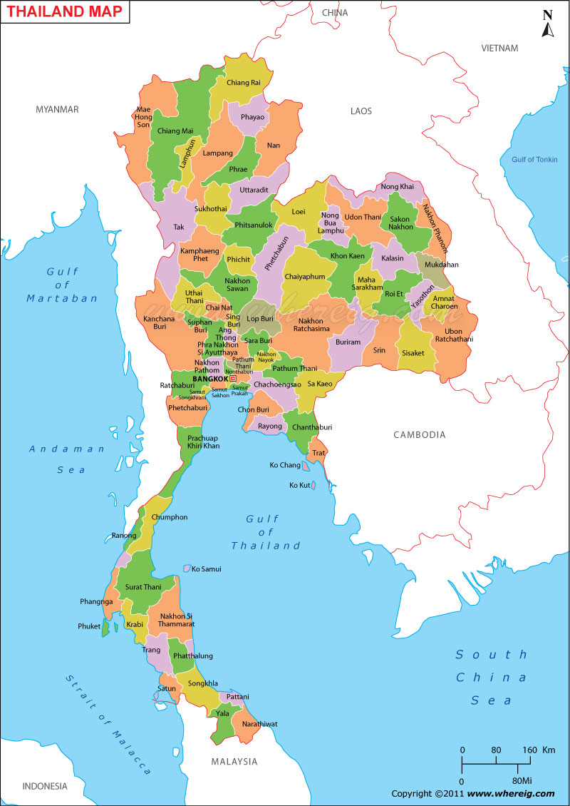
Description: The Political Map of Thailand showing Thailand States, cities, capital, international and state boundaries.
Thailand is the 51st largest country in the world, located in Southeastern region of Asia. Thailand shares its border with countries like Myanmar, Laos, Cambodia and Malaysia. Thailand lies between latitudes 5°40' and 20°30' N and longitudes 97°20' and 105°. 45' E. It covers an area of of 514,000 sq km. Bangkok is the Capital of Thailand.
Continent: Asia
Country Name: Kingdom of Thailand
Where is Located: located at the centre of the Indochina peninsula in Southeast Asia.
Neighboring Countries: Vietnam in the Gulf of Thailand to the southeast, and Indonesia and India in the Andaman Sea to the southwest.
Capital City: Bangkok
Proviences:> 76 Official language: Thai
Population: 69,122,234 (2010)
Area of Thailand: 198,115 sq miles (513,115 sq km)
GDP: $318.52 Billion USD
Legislature: National Assembly
Government: Unitary parliamentary democracy Constitutional monarchy
Time zone: (UTC+7)
Calling code: +66
ISO Code: TH
Thailand is the 51st largest country in the world, located in Southeastern region of Asia. Thailand shares its border with countries like Myanmar, Laos, Cambodia and Malaysia. Thailand lies between latitudes 5°40' and 20°30' N and longitudes 97°20' and 105°. 45' E. It covers an area of of 514,000 sq km. Bangkok is the Capital of Thailand.
About Thailand
Continent: Asia
Country Name: Kingdom of Thailand
Where is Located: located at the centre of the Indochina peninsula in Southeast Asia.
Neighboring Countries: Vietnam in the Gulf of Thailand to the southeast, and Indonesia and India in the Andaman Sea to the southwest.
Capital City: Bangkok
Proviences:> 76 Official language: Thai
Population: 69,122,234 (2010)
Area of Thailand: 198,115 sq miles (513,115 sq km)
GDP: $318.52 Billion USD
Legislature: National Assembly
Government: Unitary parliamentary democracy Constitutional monarchy
Time zone: (UTC+7)
Calling code: +66
ISO Code: TH
Asian Countries Location Maps
- Where is Afghanistan
- Where is Armenia
- Where is Azerbaijan
- Where is Bahrain
- Where is Bangladesh
- Where is Bhutan
- Where is Brunei
- Where is Burma
- Where is Cambodia
- Where is China
- Where is Georgia
- Where is Hong Kong
- Where is India
- Where is Indonesia
- Where is Iran
- Where is Iraq
- Where is Israel


