
Written and Fact-checked by Whereig Editors | Last Updated On: June 15, 2026
The Democratic Republic of the Congo is located in Central Africa and is one of the continent's largest countries. It lies between latitudes 13°S and 5°N and longitudes 12°E and 32°E. It shares borders with Republic of the Congo, Central African Republic, South Sudan, Uganda, Rwanda, Burundi, Tanzania, Zambia, and Angola. Discover its location on the map, capital city Kinshasa, population, major cities, geography, and other key facts about this diverse African nation.
Location Map of Democratic Republic of the Congo
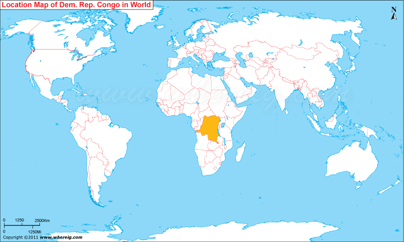
About Map: The map shows the location of the Democratic Republic of the Congo, a large country situated in Central Africa. It shares borders with nine countries and has a short coastline along the Atlantic Ocean.
The Democratic Republic of the Congo, also known as DR Congo, is a large country in Central Africa. It covers area about 905,567 square miles (2,344,858 square kilometers) and has a population of more than 110 million people. Kinshasa is the national capital and the largest city of the country and one of Africa's biggest urban centers.
DR Congo shares borders with nine countries: the Republic of the Congo to the west, the Central African Republic and South Sudan to the north, Uganda, Rwanda, Burundi, and Tanzania to the east, and Zambia and Angola to the south.
Much of the country is covered by the Congo Basin rainforest, making it one of the most important tropical forest regions in the world. The Congo River, which flows across the country, is a major transportation route and one of Africa's most significant rivers. DR Congo is also known for its rich wildlife, national parks, mountains, lakes, and valuable mineral resources.
The area has a long history that stretches back to powerful African kingdoms and trading communities. After a period of Belgian colonial rule, the country gained independence in 1960. Today, DR Congo is known for its cultural diversity, natural beauty, and important role in Central Africa.
- Capital: Kinshasa
- Official Language: French; Lingala, Swahili, Kikongo, and Tshiluba are widely spoken national languages
- Currency: Congolese Franc (CDF)
Provinces of Democratic Republic of the Congo
| Province | Capital | Population | Area | Latitude and Longitude |
|---|---|---|---|---|
| Kinshasa | Kinshasa | 17,000,000+ | 9,965 sq km (3,848 sq mi) | 4.4419° S, 15.2663° E |
| Haut-Katanga | Lubumbashi | 7,000,000+ | 132,425 sq km (51,130 sq mi) | 11.6870° S, 27.5026° E |
| Kongo Central | Matadi | 6,000,000+ | 53,920 sq km (20,818 sq mi) | 5.8277° S, 13.4500° E |
| Tshopo | Kisangani | 3,500,000+ | 199,567 sq km (77,053 sq mi) | 0.5153° N, 25.1911° E |
| South Kivu | Bukavu | 7,000,000+ | 65,070 sq km (25,124 sq mi) | 2.5123° S, 28.8480° E |
| North Kivu | Goma | 8,000,000+ | 59,631 sq km (23,024 sq mi) | 1.6792° S, 29.2228° E |
| Kasai Central | Kananga | 4,000,000+ | 59,111 sq km (22,823 sq mi) | 5.8962° S, 22.4178° E |
| Lualaba | Kolwezi | 2,500,000+ | 121,308 sq km (46,837 sq mi) | 10.7148° S, 25.4667° E |
| Tanganyika | Kalemie | 3,000,000+ | 134,940 sq km (52,100 sq mi) | 5.9475° S, 29.1947° E |
| Ituri | Bunia | 5,000,000+ | 65,658 sq km (25,351 sq mi) | 1.5594° N, 30.2522° E |
10 Largest Cities in Democratic Republic of the Congo
| City | Province | Population | Latitude and Longitude |
|---|---|---|---|
| Kinshasa | Kinshasa | 17,000,000+ | 4.4419° S, 15.2663° E |
| Lubumbashi | Haut-Katanga | 2,500,000+ | 11.6870° S, 27.5026° E |
| Mbuji-Mayi | Kasai Oriental | 2,000,000+ | 6.1360° S, 23.5898° E |
| Kisangani | Tshopo | 1,500,000+ | 0.5153° N, 25.1911° E |
| Kananga | Kasai Central | 1,200,000+ | 5.8962° S, 22.4178° E |
| Bukavu | South Kivu | 1,000,000+ | 2.5123° S, 28.8480° E |
| Goma | North Kivu | 900,000+ | 1.6792° S, 29.2228° E |
| Kolwezi | Lualaba | 700,000+ | 10.7148° S, 25.4667° E |
| Matadi | Kongo Central | 400,000+ | 5.8277° S, 13.4500° E |
| Boma | Kongo Central | 350,000+ | 5.8500° S, 13.0500° E |
Top Tourist Attractions and Famous Places to Visit in Democratic Republic of the Congo
- Virunga National Park - North Kivu
- Mount Nyiragongo - North Kivu
- Kahuzi-Biéga National Park - South Kivu
- Lola ya Bonobo Sanctuary - Kinshasa
- Livingstone Falls - Congo River
- Lake Kivu - Eastern DR Congo
- Boyoma Falls - Tshopo
- Okapi Wildlife Reserve - Ituri
- Garamba National Park - Haut-Uele
- Upemba National Park - Haut-Lomami
- Lake Tanganyika - Tanganyika
- Maiko National Park - Eastern DR Congo
- Congo River Waterfront - Kinshasa
- Kinshasa National Museum - Kinshasa
- Mount Stanley Region - Rwenzori Mountains
- Mangrove Coastline - Kongo Central
Democratic Republic of the Congo Facts
| Continent | Africa |
| Country | Democratic Republic of the Congo |
| Capital | Kinshasa |
| Largest City | Kinshasa |
| Coordinates | 4.0383° S, 21.7587° E |
| Administrative Divisions | 26 Provinces |
| Official Language | French |
| Demonym | Congolese |
| Government | Unitary Semi-Presidential Republic |
| Independence | 1960 |
| Total Area | 2,344,858 sq km (905,567 sq mi) |
| Population | 110,000,000+ (2025 est.) |
| Population Density | 47 people per sq km |
| Currency | Congolese Franc (CDF) |
| Economy | Mining, Agriculture and Services |
| Country Calling Code | +243 |
| Time Zone | UTC+1 to UTC+2 |
| Internet TLD | .cd |
| ISO Country Code | CD |
| Driving Side | Right |
| Major Cities | Kinshasa, Lubumbashi, Mbuji-Mayi, Kisangani, Kananga |
| Major Airports | N'djili International Airport, Lubumbashi International Airport |
| Highest Point | Mount Stanley (5,109 m) |
| Longest River | Congo River |
| Climate | Equatorial Tropical Climate |
| Average Temperature | 21°C to 31°C |
| Famous For | Congo River, Rainforests, Gorillas, Minerals and National Parks |
| National Animal | Okapi |
| National Sport | Football |
| National Dish | Moambe Chicken |
| Official Website | primature.gouv.cd |
Major Rivers in Democratic Republic of the Congo
- Congo River
- Lualaba River
- Kasai River
- Ubangi River
- Lomami River
- Sankuru River
- Aruwimi River
- Ruzizi River
Democratic Republic of the Congo Climate Facts
| Climate Type | Equatorial Tropical Climate |
| Average Temperature | 21°C to 31°C |
| Rainy Season | October to May (varies by region) |
| Average Annual Rainfall | 1,000 mm to 2,000 mm+ |
Neighboring Countries of Democratic Republic of the Congo
- Republic of the Congo - West
- Central African Republic - North
- South Sudan - Northeast
- Uganda - East
- Rwanda - East
- Burundi - East
- Tanzania - East
- Zambia - South
- Angola - South and Southwest
References
- Presidency of the Democratic Republic of the Congo
- Prime Minister's Office of the Democratic Republic of the Congo
- National Institute of Statistics (INS-RDC)
- World Bank - Democratic Republic of the Congo
- United Nations World Population Prospects
- CIA World Factbook - Democratic Republic of the Congo
- UNESCO World Heritage Centre
- Where is Algeria
- Where is Angola
- Where is Benin
- Where is Botswana
- Where is Burkina Faso
- Where is Burundi
- Where is Cameroon
- Where is Canary Islands
- Where is Cape Verde
- Central African Republic
- Where is Ceuta
- Where is Chad
- Where is Cote d'Ivoire
- Where is Congo
- Where is Djibouti
- Where is Egypt
- Equatorial Guinea
- Where is Eritrea
- Where is Ethiopia
- Where is Gabon
- Where is Gambia
- Where is Ghana
- Where is Guinea
- Guinea Bissau
- Where is Kenya
- Where is Lesotho
- Where is Liberia
- Where is Libya
- Where is Madagascar
- Where is Madeira
- Where is Malawi
- Where is Mali
- Where is Mauritania
- Where is Mauritius
- Where is Mayotte
- Where is Melilla
- Where is Morocco
- Where is Mozambique
- Where is Namibia
- Where is Niger
- Where is Nigeria
- Republic of the Congo
- Where is Reunion
- Where is Rwanda
- Where is Saint Helena
- Sao Tome and Principe
- Where is Senegal
- Where is Seychelles
- Where is Sierra Leone
- Where is South Africa
- Where is Sudan
- Where is Swaziland
- Where is Tanzania
- Where is Togo
- Where is Tunisia
- Where is Uganda
- Where is Western Sahara
- Where is Zambia
- Where is Zimbabwe