Map of Gulf County - Gulf County is a county located in the U.S. state of Florida. Gulf County Map showing cities, highways, important places and water bodies. Get Where is Gulf County located in the map, major cities in Gulf county, population, areas, and places of interest.
Map of Gulf County, Florida
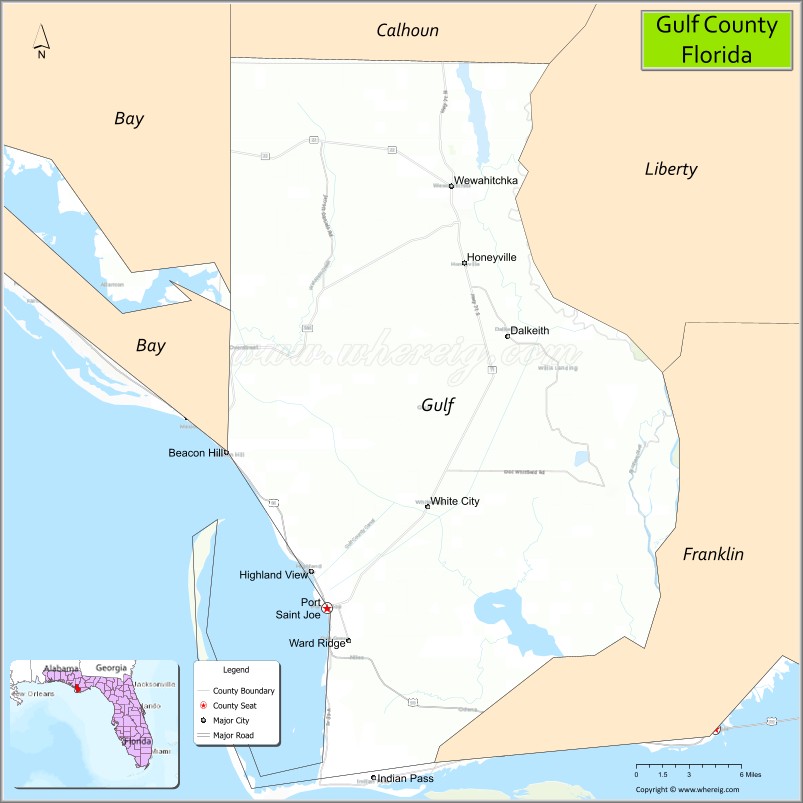
About Gulf County Map, Florida: The map showing the county boundary, county seat, major cities, highways, water bodies and neighbouring counties.
Most Viewed Links
About Gulf County, Florida
Gulf County is located in the northwestern part of Florida, in the state of the United States. The county was established in 1925 and was named after the Gulf of Mexico, which borders its southern coastline. The county seat is Port St. Joe, which is also the largest city. Gulf County is known for its coastal communities, fishing industry, and scenic beaches in the Florida Panhandle.
Population
According to the United States Census Bureau, the population of Gulf County is 14,192 as recorded in the 2020 Census, and the population density is approximately 25 people per square mile.
Area and Geography
According to the United States Census Bureau, Gulf County covers a total area of approximately 756 square miles (about 1,958 square kilometers), including about 559 square miles (1,448 square kilometers) of land and 197 square miles (510 square kilometers) of water. The county features Gulf of Mexico coastline, St. Joseph Bay, barrier islands, and inland forests, contributing to both tourism and natural resource industries.
Bordering Counties
Gulf County shares boundaries with Jackson County to the north, Calhoun County to the northeast, Liberty County to the east, Franklin County to the southeast, and Bay County to the west.
Major Cities and Communities
Major cities and towns include Port St. Joe, Wewahitchka, Mexico Beach, and Overstreet.
Attractions and Recreation
Gulf County offers beaches, boating, fishing, and nature trails along St. Joseph Bay and the Gulf Coast. Outdoor recreation is central to the local economy, with activities including kayaking, camping, and wildlife observation. Gulf Coast State College serves residents in the surrounding region and supports higher education access nearby.
Transportation
Gulf County is served by U.S. Highway 98 along the coast and State Road 71, which provides north-south connectivity through the county. These routes connect coastal communities with inland areas of the Florida Panhandle.
Explore more counties in Florida Counties or view the complete USA States Map section for additional geographic information.
Sources:
Population and area data sourced from the United States Census Bureau (2020 Census). General county information referenced from the Official Gulf County Government Website.
Facts about Gulf County, Florida
| Country | United States |
| State | Florida |
| Region | Florida Panhandle (Forgotten Coast) |
| County Seat | Port St. Joe |
| Named After | Gulf of Mexico |
| Established | 1925 |
| Organized | 1925 |
| Coordinates | 29.9086° N, 85.2566° W |
| Total Area | 748 sq mi |
| Land Area | 564 sq mi |
| Water Area | 184 sq mi |
| Population (2020) | 14,192 |
| Population Rank | Small coastal county in the Florida Panhandle |
| Major City | Port St. Joe |
| Main Industries | Tourism, Fishing, Forestry, Public Services |
| Major Airport | Gulf County Airport |
| Time Zone | Eastern Time (UTC−05:00) |
| Known For | St. Joseph Peninsula, beaches, scalloping, Forgotten Coast |
| Website | https://www.gulfcounty-fl.gov |
Ctities in Gulf county
| City Name | Type | Population (2020) | Pop. Density | Area | Incorporated |
|---|---|---|---|---|---|
| Port St. Joe | City | 3,357 | 3.3 sq mi (8.6 km2) | 1913 | |
| Wewahitchka | City | 2,074 | 7.4 sq mi (19.3 km2) | 1959 |
Top Attractions in Gulf County, Florida
- Cape San Blas – Pristine beaches and lighthouse views.
- St. Joseph Peninsula State Park – Beaches, dunes, and wildlife.
- Indian Pass – Quiet coastal village and fishing.
- Port St. Joe Downtown – Shops, dining, and waterfront.
- St. Joseph Bay – Kayaking and snorkeling.
- Gulf County Welcome Center – Local travel information.
- Money Bayou – Fishing and scenic views.
- Dead Lakes State Recreation Area – Cypress swamp and fishing.
- Salinas Park – Beach access and picnicking.
- Scenic Coastal Drives – Gulf and bay views.
Highways in Gulf
CR 22, CR 22A, CR 30A, CR 30B, CR 71A, CR 381, CR 381A, CR 382.
Nearest Airports
Nearest airport of Gulf is Costin Airport.
- Alachua County Map
- Baker County Map
- Bay County Map
- Bradford County Map
- Brevard County Map
- Broward County Map
- Calhoun County Map
- Charlotte County Map
- Citrus County Map
- Clay County Map
- Collier County Map
- Columbia County Map
- DeSoto County Map
- Dixie County Map
- Duval County Map
- Escambia County Map
- Flagler County Map
- Franklin County Map
- Gadsden County Map
- Gilchrist County Map
- Glades County Map
- Gulf County Map
- Hamilton County Map
- Hardee County Map
- Hendry County Map
- Hernando County Map
- Highlands County Map
- Hillsborough County Map
- Holmes County Map
- Indian River County Map
- Jackson County Map
- Jefferson County Map
- Lafayette County Map
- Lake County Map
- Lee County Map
- Leon County Map
- Levy County Map
- Liberty County Map
- Madison County Map
- Manatee County Map
- Marion County Map
- Martin County Map
- Miami-Dade County Map
- Monroe County Map
- Nassau County Map
- Okaloosa County Map
- Okeechobee County Map
- Orange County Map
- Osceola County Map
- Palm Beach County Map
- Pasco County Map
- Pinellas County Map
- Polk County Map
- Putnam County Map
- St Johns County Map
- St Lucie County Map
- Santa Rosa County Map
- Sarasota County Map
- Seminole County Map
- Sumter County Map
- Suwannee County Map
- Taylor County Map
- Union County Map
- Volusia County Map
- Wakulla County Map
- Walton County Map
- Washington County Map
- Where is Miami
- Where is Hialeah
- Where is Jacksonville
- Where is Orlando
- Where is Saint Petersburg
- Where is Tampa
- Where is Alafaya
- Where is Boca Raton
- Where is Boynton Beach
- Where is Brandon
- Where is Cape Coral
- Where is Clearwater
- Where is Coral Springs
- Where is Davie
- Where is Daytona Beach
- Where is Deerfield Beach
- Where is Deltona
- Where is Doral
- Where is Fort Lauderdale
- Where is Fort Myers
- Where is Gainesville
- Where is Hollywood
- Where is Homestead
- Where is Horizon West
- Where is Kendall
- Where is Kissimmee
- Where is Lakeland
- Where is Largo
- Where is Lauderhill
- Where is Lehigh Acres
- Where is Melbourne
- Where is Miami Beach
- Where is Miami Gardens
- Where is Miramar
- Where is North Port
- Where is Palm Bay
- Where is Palm Coast
- Where is Pembroke Pines
- Where is Plantation
- Where is Poinciana
- Where is Pompano Beach
- Where is Port St. Lucie
- Where is Riverview
- Where is Spring Hill
- Where is St. Petersburg
- Where is Sunrise
- Where is Tallahassee
- Where is Tamarac
- Where is The Villages
- Where is Town 'n' Country
- Where is West Palm Beach