Map of Leon County - Leon County is a county located in the U.S. state of Florida. Leon County Map showing cities, highways, important places and water bodies. Get Where is Leon County located in the map, major cities in Leon county, population, areas, and places of interest.
Map of Leon County, Florida
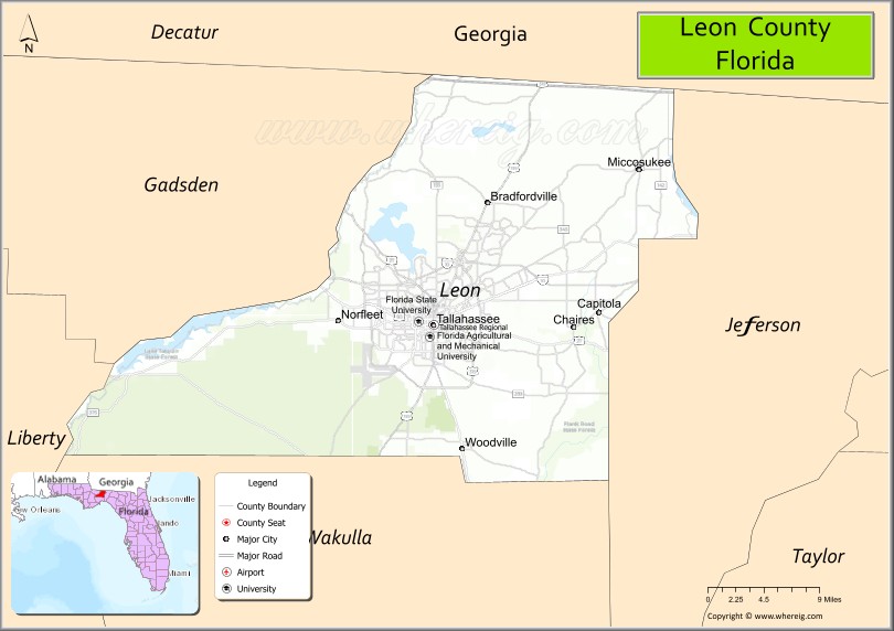
About Leon County Map, Florida: The map showing the county boundary, county seat, major cities, highways, water bodies and neighbouring counties.
Most Viewed Links
About Leon County, Florida
Leon County is located in the northwestern part of Florida, in the state of the United States. The county was established in 1824 and was named after Juan Ponce de León, the Spanish explorer associated with early expeditions to Florida. The county seat and largest city is Tallahassee, which also serves as the capital of Florida. Leon County is known for its governmental institutions, universities, and historic districts.
Population
According to the United States Census Bureau, the population of Leon County is 292,198 as recorded in the 2020 Census, and the population density is approximately 436 people per square mile.
Area and Geography
According to the United States Census Bureau, Leon County covers a total area of approximately 702 square miles (about 1,818 square kilometers), including about 667 square miles (1,727 square kilometers) of land and 35 square miles (91 square kilometers) of water. The county features rolling hills, canopy roads, lakes, and forested areas that distinguish it from flatter coastal regions of Florida.
Bordering Counties
Leon County shares boundaries with Georgia to the north, Gadsden County to the west, Wakulla County to the south, and Jefferson County to the east.
Major Cities and Communities
Major cities and towns include Tallahassee, Woodville, and Miccosukee.
Attractions and Recreation
Leon County offers cultural attractions, parks, and historic sites in Tallahassee, including museums and government landmarks. Outdoor recreation includes trails, lakes, and natural preserves. The county is home to Florida State University, Florida A&M University, and Tallahassee State College, making it a major center for higher education in Florida.
Transportation
Leon County is served by Interstate 10 and U.S. Highway 27, providing regional connectivity across the Florida Panhandle. Tallahassee International Airport supports commercial air travel and access to the state capital region.
Explore more counties in Florida Counties or view the complete USA States Map section for additional geographic information.
Sources:
Population and area data sourced from the United States Census Bureau (2020 Census). General county information referenced from the Official Leon County Government Website.
Facts about Leon County, Florida
| Country | United States |
| State | Florida |
| Region | North Florida (Big Bend) |
| County Seat | Tallahassee |
| Named After | Juan Ponce de León |
| Established | 1824 |
| Organized | 1824 |
| Coordinates | 30.4906° N, 84.1857° W |
| Total Area | 702 sq mi |
| Land Area | 667 sq mi |
| Water Area | 35 sq mi |
| Population (2020) | 292,198 |
| Population Rank | One of the most populous counties in North Florida |
| Major City | Tallahassee |
| Main Industries | Government, Education, Healthcare, Research |
| Major Airport | Tallahassee International Airport |
| Time Zone | Eastern Time (UTC−05:00) |
| Known For | Florida State Capitol, Florida State University, rolling red hills |
| Website | https://www.leoncountyfl.gov |
Ctities in Leon county
| City Name | Type | Population (2020) | Pop. Density | Area | Incorporated |
|---|---|---|---|---|---|
| Tallahassee # | City | 196,169 | 103.1 sq mi (267.0 km2) | 1825 |
Top Attractions in Leon County, Florida
- Florida State Capitol – Historic and modern capitol buildings.
- Florida State University Campus – Museums and cultural venues.
- Alfred B. Maclay Gardens State Park – Formal gardens and lakes.
- Cascades Park – Downtown green space and events.
- Tallahassee Museum – History, nature, and wildlife.
- Mission San Luis – Reconstructed Spanish mission.
- Lake Ella & Fred Drake Park – Lakeside walking paths.
- Downtown Tallahassee – Dining, nightlife, and culture.
- San Marcos de Apalache Historic State Park (nearby) – Historic fort site.
- Scenic Canopy Roads – Tree-lined countryside drives.
Highways in Leon
Interstate 10, U.S. Highway 27, U.S. Highway 90, U.S. Highway 319, State Road 20, State Road 61, State Road 155, State Road 263, State Road 267, State Road 363.
Nearest Airports
Nearest airport of Leon are Tallahassee Commercial Airport, Tallahassee International Airport.
- Alachua County Map
- Baker County Map
- Bay County Map
- Bradford County Map
- Brevard County Map
- Broward County Map
- Calhoun County Map
- Charlotte County Map
- Citrus County Map
- Clay County Map
- Collier County Map
- Columbia County Map
- DeSoto County Map
- Dixie County Map
- Duval County Map
- Escambia County Map
- Flagler County Map
- Franklin County Map
- Gadsden County Map
- Gilchrist County Map
- Glades County Map
- Gulf County Map
- Hamilton County Map
- Hardee County Map
- Hendry County Map
- Hernando County Map
- Highlands County Map
- Hillsborough County Map
- Holmes County Map
- Indian River County Map
- Jackson County Map
- Jefferson County Map
- Lafayette County Map
- Lake County Map
- Lee County Map
- Leon County Map
- Levy County Map
- Liberty County Map
- Madison County Map
- Manatee County Map
- Marion County Map
- Martin County Map
- Miami-Dade County Map
- Monroe County Map
- Nassau County Map
- Okaloosa County Map
- Okeechobee County Map
- Orange County Map
- Osceola County Map
- Palm Beach County Map
- Pasco County Map
- Pinellas County Map
- Polk County Map
- Putnam County Map
- St Johns County Map
- St Lucie County Map
- Santa Rosa County Map
- Sarasota County Map
- Seminole County Map
- Sumter County Map
- Suwannee County Map
- Taylor County Map
- Union County Map
- Volusia County Map
- Wakulla County Map
- Walton County Map
- Washington County Map
- Where is Miami
- Where is Hialeah
- Where is Jacksonville
- Where is Orlando
- Where is Saint Petersburg
- Where is Tampa
- Where is Alafaya
- Where is Boca Raton
- Where is Boynton Beach
- Where is Brandon
- Where is Cape Coral
- Where is Clearwater
- Where is Coral Springs
- Where is Davie
- Where is Daytona Beach
- Where is Deerfield Beach
- Where is Deltona
- Where is Doral
- Where is Fort Lauderdale
- Where is Fort Myers
- Where is Gainesville
- Where is Hollywood
- Where is Homestead
- Where is Horizon West
- Where is Kendall
- Where is Kissimmee
- Where is Lakeland
- Where is Largo
- Where is Lauderhill
- Where is Lehigh Acres
- Where is Melbourne
- Where is Miami Beach
- Where is Miami Gardens
- Where is Miramar
- Where is North Port
- Where is Palm Bay
- Where is Palm Coast
- Where is Pembroke Pines
- Where is Plantation
- Where is Poinciana
- Where is Pompano Beach
- Where is Port St. Lucie
- Where is Riverview
- Where is Spring Hill
- Where is St. Petersburg
- Where is Sunrise
- Where is Tallahassee
- Where is Tamarac
- Where is The Villages
- Where is Town 'n' Country
- Where is West Palm Beach