Map of Hillsborough County - Hillsborough County is a county located in the U.S. state of Florida. Hillsborough County Map showing cities, highways, important places and water bodies. Get Where is Hillsborough County located in the map, major cities in Hillsborough county, population, areas, and places of interest.
Map of Hillsborough County, Florida
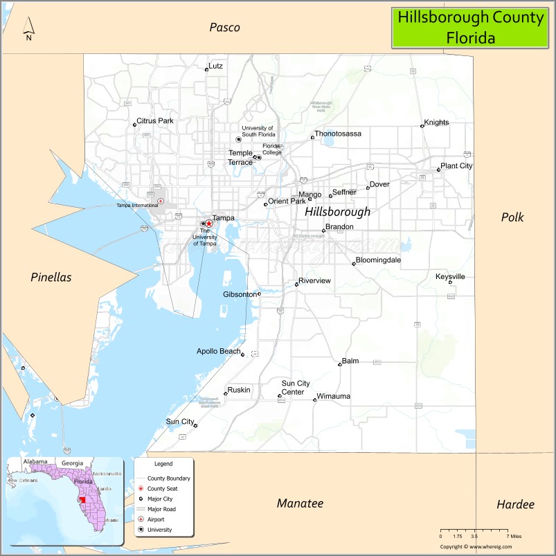
About Hillsborough County Map, Florida: The map showing the county boundary, county seat, major cities, highways, water bodies and neighbouring counties.
Most Viewed Links
About Hillsborough County, Florida
Hillsborough County is located in the west-central part of Florida, in the state of the United States. The county was established in 1834 and was named after Wills Hill, the Earl of Hillsborough, a British statesman. The county seat and largest city is Tampa. Hillsborough County is part of the Tampa Bay metropolitan area and is known for its major port, diverse economy, and rapidly growing population.
Population
According to the United States Census Bureau, the population of Hillsborough County is 1,459,762 as recorded in the 2020 Census, and the population density is approximately 1,420 people per square mile.
Area and Geography
According to the United States Census Bureau, Hillsborough County covers a total area of approximately 1,266 square miles (about 3,279 square kilometers), including about 1,020 square miles (2,642 square kilometers) of land and 246 square miles (637 square kilometers) of water. The county features Tampa Bay shoreline, rivers, urban centers, and expanding suburban communities.
Bordering Counties
Hillsborough County shares boundaries with Pasco County to the north, Polk County to the east, Manatee County to the south, and Pinellas County to the west.
Major Cities and Communities
Major cities and towns include Tampa, Plant City, Temple Terrace, Brandon, and Riverview.
Attractions and Recreation
Hillsborough County offers cultural attractions, waterfront parks, and professional sports venues in Tampa. Outdoor recreation includes boating along Tampa Bay and trails in conservation areas. The county is also home to the University of South Florida and Hillsborough Community College, contributing significantly to higher education and research in the region.
Transportation
Hillsborough County is served by Interstate 4, Interstate 75, and Interstate 275, providing major regional connectivity. Tampa International Airport supports domestic and international travel, and Port Tampa Bay serves as a major cargo and cruise port.
Explore more counties in Florida Counties or view the complete USA States Map section for additional geographic information.
Sources:
Population and area data sourced from the United States Census Bureau (2020 Census). General county information referenced from the Official Hillsborough County Government Website.
Facts about Hillsborough County, Florida
| Country | United States |
| State | Florida |
| Region | West Central Florida (Tampa Bay) |
| County Seat | Tampa |
| Named After | Wills Hill, Earl of Hillsborough |
| Established | 1834 |
| Organized | 1834 |
| Coordinates | 27.9506° N, 82.4572° W |
| Total Area | 1,266 sq mi |
| Land Area | 1,020 sq mi |
| Water Area | 246 sq mi |
| Population (2020) | 1,459,762 |
| Population Rank | Fourth most populous county in Florida |
| Major City | Tampa |
| Main Industries | Healthcare, Finance, Tourism, Technology, Port Operations |
| Major Airport | Tampa International Airport |
| Time Zone | Eastern Time (UTC−05:00) |
| Known For | Tampa Bay, Port of Tampa, professional sports teams |
| Website | https://www.hillsboroughcounty.org |
Ctities in Hillsborough county
| City Name | Type | Population (2020) | Pop. Density | Area | Incorporated |
|---|---|---|---|---|---|
| Plant City | City | 39,764 | 22.7 sq mi (58.9 km2) | 1885 | |
| Tampa | City | 384,959 | 170.6 sq mi (441.9 km2) | 1855 | |
| Temple Terrace | City | 26,690 | 7.0 sq mi (18.0 km2) | 1925 |
Top Attractions in Hillsborough County, Florida
- Busch Gardens Tampa Bay – Theme park and wildlife attractions.
- Tampa Riverwalk – Scenic waterfront walking path.
- Florida Aquarium – Marine life exhibits.
- Ybor City Historic District – Cuban heritage and nightlife.
- Tampa Museum of Art – Modern and classical art.
- ZooTampa at Lowry Park – Family-friendly zoo.
- Amalie Arena – Hockey games and concerts.
- Big Cat Rescue – Big cat sanctuary.
- Curtis Hixon Waterfront Park – Events and river views.
- Adventure Island – Water park fun.
Highways in Hillsborough
Interstate 4, Interstate 75, Interstate 275, U.S Routes, g U.S. Route 41, U.S. Route 92, U.S. Route 301, State Route 618, State Road 60, State Road 589, State Road 580, .
Nearest Airports
Nearest airport of Hillsborough is Tampa International Airport).
- Alachua County Map
- Baker County Map
- Bay County Map
- Bradford County Map
- Brevard County Map
- Broward County Map
- Calhoun County Map
- Charlotte County Map
- Citrus County Map
- Clay County Map
- Collier County Map
- Columbia County Map
- DeSoto County Map
- Dixie County Map
- Duval County Map
- Escambia County Map
- Flagler County Map
- Franklin County Map
- Gadsden County Map
- Gilchrist County Map
- Glades County Map
- Gulf County Map
- Hamilton County Map
- Hardee County Map
- Hendry County Map
- Hernando County Map
- Highlands County Map
- Hillsborough County Map
- Holmes County Map
- Indian River County Map
- Jackson County Map
- Jefferson County Map
- Lafayette County Map
- Lake County Map
- Lee County Map
- Leon County Map
- Levy County Map
- Liberty County Map
- Madison County Map
- Manatee County Map
- Marion County Map
- Martin County Map
- Miami-Dade County Map
- Monroe County Map
- Nassau County Map
- Okaloosa County Map
- Okeechobee County Map
- Orange County Map
- Osceola County Map
- Palm Beach County Map
- Pasco County Map
- Pinellas County Map
- Polk County Map
- Putnam County Map
- St Johns County Map
- St Lucie County Map
- Santa Rosa County Map
- Sarasota County Map
- Seminole County Map
- Sumter County Map
- Suwannee County Map
- Taylor County Map
- Union County Map
- Volusia County Map
- Wakulla County Map
- Walton County Map
- Washington County Map
- Where is Miami
- Where is Hialeah
- Where is Jacksonville
- Where is Orlando
- Where is Saint Petersburg
- Where is Tampa
- Where is Alafaya
- Where is Boca Raton
- Where is Boynton Beach
- Where is Brandon
- Where is Cape Coral
- Where is Clearwater
- Where is Coral Springs
- Where is Davie
- Where is Daytona Beach
- Where is Deerfield Beach
- Where is Deltona
- Where is Doral
- Where is Fort Lauderdale
- Where is Fort Myers
- Where is Gainesville
- Where is Hollywood
- Where is Homestead
- Where is Horizon West
- Where is Kendall
- Where is Kissimmee
- Where is Lakeland
- Where is Largo
- Where is Lauderhill
- Where is Lehigh Acres
- Where is Melbourne
- Where is Miami Beach
- Where is Miami Gardens
- Where is Miramar
- Where is North Port
- Where is Palm Bay
- Where is Palm Coast
- Where is Pembroke Pines
- Where is Plantation
- Where is Poinciana
- Where is Pompano Beach
- Where is Port St. Lucie
- Where is Riverview
- Where is Spring Hill
- Where is St. Petersburg
- Where is Sunrise
- Where is Tallahassee
- Where is Tamarac
- Where is The Villages
- Where is Town 'n' Country
- Where is West Palm Beach