Map of Baker County - Baker County is a county located in the U.S. state of Florida. Baker County Map showing cities, highways, important places and water bodies. Get Where is Baker County located in the map, major cities in Baker county, population, areas, and places of interest.
Map of Baker County, Florida
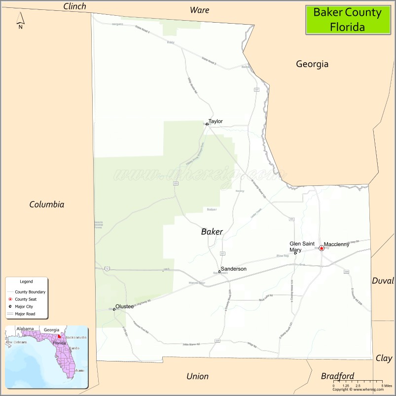
About Baker County Map, Florida: The map showing the county boundary, county seat, major cities, highways, water bodies and neighbouring counties.
Most Viewed Links
About Baker County, Florida
Baker County is located in the northeastern part of Florida, in the state of the United States. The county was established in 1861 and was named after James McNair Baker, a judge and Confederate senator. The county seat and largest city is Macclenny. Baker County maintains a largely rural character and is known for its forestry, agriculture, and close proximity to the Jacksonville metropolitan area.
Population
According to the United States Census Bureau, the population of Baker County is 28,259 as recorded in the 2020 Census, and the population density is approximately 48 people per square mile.
Area and Geography
According to the United States Census Bureau, Baker County covers a total area of approximately 589 square miles (about 1,526 square kilometers), including about 585 square miles (1,515 square kilometers) of land and 4 square miles (10 square kilometers) of water. The county features flat terrain, extensive pine forests, and river systems, including portions of the St. Marys River along its northern boundary.
Bordering Counties
Baker County shares boundaries with Georgia to the north, Nassau County to the northeast, Duval County to the east, Clay County to the southeast, Bradford County to the south, and Union County to the southwest.
Major Cities and Communities
Major cities and towns include Macclenny, Glen St. Mary, Sanderson, and Olustee.
Attractions and Recreation
Baker County offers outdoor recreation opportunities within Osceola National Forest, where visitors can enjoy hiking, camping, hunting, and wildlife observation. The Olustee Battlefield Historic State Park commemorates Florida’s largest Civil War battle and attracts history enthusiasts throughout the year.
Transportation
Baker County is served by Interstate 10, which runs east-west through the region, and U.S. Highway 90, providing local and regional connectivity. Its location near Jacksonville supports commuting and economic ties to Northeast Florida.
Explore more counties in Florida Counties or view the complete USA States Map section for additional geographic information.
Sources:
Population and area data sourced from the United States Census Bureau (2020 Census). General county information referenced from the Official Baker County Government Website.
Facts about Baker County, Florida
| Country | United States |
| State | Florida |
| Region | Northeast Florida |
| County Seat | Macclenny |
| Named After | James McNair Baker, Confederate Senator |
| Established | 1861 |
| Organized | 1861 |
| Coordinates | 30.3250° N, 82.3020° W |
| Total Area | 585 sq mi |
| Land Area | 585 sq mi |
| Water Area | <1 sq mi |
| Population (2020) | 28,259 |
| Population Rank | Small county in Northeast Florida |
| Major City | Macclenny |
| Main Industries | Agriculture, Forestry, Corrections, Manufacturing |
| Major Airport | None (nearest major airport: Jacksonville International Airport) |
| Time Zone | Eastern Time (UTC−05:00) |
| Known For | Osceola National Forest, Rural North Florida landscapes, Small-town heritage |
| Website | https://www.bakercountyfl.org |
Top Attractions in Baker County, Florida
- Osceola National Forest – Hiking, camping, and wildlife.
- Olustee Battlefield Historic State Park – Civil War battle site.
- Downtown Macclenny – Small-town shops and charm.
- Baker County Courthouse – Historic courthouse landmark.
- Heritage Park Village – Restored historic buildings.
- Glen St. Mary Downtown – Local shops and history.
- Ocean Pond – Swimming, fishing, and picnicking.
- Lake Prichard – Quiet fishing and nature area.
- Scenic Forest Drives – Pine forests and wetlands.
- Local Nature Trails – Easy walking and birdwatching.
- Alachua County Map
- Baker County Map
- Bay County Map
- Bradford County Map
- Brevard County Map
- Broward County Map
- Calhoun County Map
- Charlotte County Map
- Citrus County Map
- Clay County Map
- Collier County Map
- Columbia County Map
- DeSoto County Map
- Dixie County Map
- Duval County Map
- Escambia County Map
- Flagler County Map
- Franklin County Map
- Gadsden County Map
- Gilchrist County Map
- Glades County Map
- Gulf County Map
- Hamilton County Map
- Hardee County Map
- Hendry County Map
- Hernando County Map
- Highlands County Map
- Hillsborough County Map
- Holmes County Map
- Indian River County Map
- Jackson County Map
- Jefferson County Map
- Lafayette County Map
- Lake County Map
- Lee County Map
- Leon County Map
- Levy County Map
- Liberty County Map
- Madison County Map
- Manatee County Map
- Marion County Map
- Martin County Map
- Miami-Dade County Map
- Monroe County Map
- Nassau County Map
- Okaloosa County Map
- Okeechobee County Map
- Orange County Map
- Osceola County Map
- Palm Beach County Map
- Pasco County Map
- Pinellas County Map
- Polk County Map
- Putnam County Map
- St Johns County Map
- St Lucie County Map
- Santa Rosa County Map
- Sarasota County Map
- Seminole County Map
- Sumter County Map
- Suwannee County Map
- Taylor County Map
- Union County Map
- Volusia County Map
- Wakulla County Map
- Walton County Map
- Washington County Map
- Where is Miami
- Where is Hialeah
- Where is Jacksonville
- Where is Orlando
- Where is Saint Petersburg
- Where is Tampa
- Where is Alafaya
- Where is Boca Raton
- Where is Boynton Beach
- Where is Brandon
- Where is Cape Coral
- Where is Clearwater
- Where is Coral Springs
- Where is Davie
- Where is Daytona Beach
- Where is Deerfield Beach
- Where is Deltona
- Where is Doral
- Where is Fort Lauderdale
- Where is Fort Myers
- Where is Gainesville
- Where is Hollywood
- Where is Homestead
- Where is Horizon West
- Where is Kendall
- Where is Kissimmee
- Where is Lakeland
- Where is Largo
- Where is Lauderhill
- Where is Lehigh Acres
- Where is Melbourne
- Where is Miami Beach
- Where is Miami Gardens
- Where is Miramar
- Where is North Port
- Where is Palm Bay
- Where is Palm Coast
- Where is Pembroke Pines
- Where is Plantation
- Where is Poinciana
- Where is Pompano Beach
- Where is Port St. Lucie
- Where is Riverview
- Where is Spring Hill
- Where is St. Petersburg
- Where is Sunrise
- Where is Tallahassee
- Where is Tamarac
- Where is The Villages
- Where is Town 'n' Country
- Where is West Palm Beach
Ctities in Baker county
| City Name | Type | Population (2020) | Pop. Density | Area | Incorporated |
|---|---|---|---|---|---|
| Glen St. Mary | Town | 463 | 0.4 sq mi (1.1 km2) | 1957 | |
| Macclenny | City | 7,304 | 3.3 sq mi (8.5 km2) | 1939 |