Map of Columbia County - Columbia County is a county located in the U.S. state of Florida. Columbia County Map showing cities, highways, important places and water bodies. Get Where is Columbia County located in the map, major cities in Columbia county, population, areas, and places of interest.
Map of Columbia County, Florida
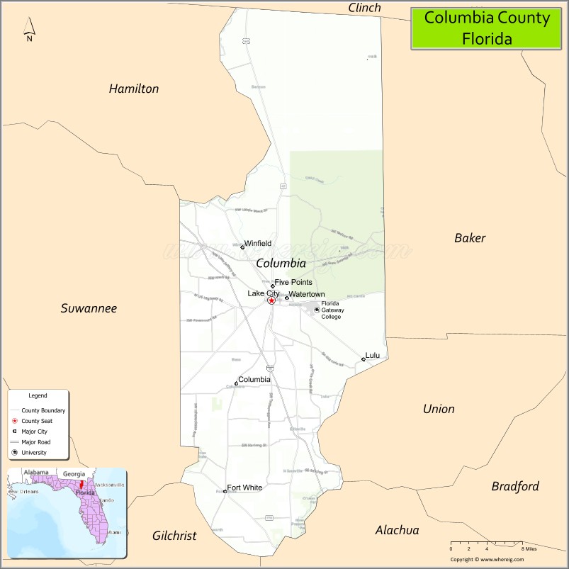
About Columbia County Map, Florida: The map showing the county boundary, county seat, major cities, highways, water bodies and neighbouring counties.
Most Viewed Links
About Columbia County, Florida
Columbia County is located in the north-central part of Florida, in the state of the United States. The county was established in 1832 and was named after Christopher Columbus. The county seat and largest city is Lake City. The county plays an important role in North Florida’s regional economy, supported by healthcare services, retail trade, agriculture, and transportation connectivity.
Population
According to the United States Census Bureau, the population of Columbia County was 69,698 as recorded in the 2020 Census.
Area and Geography
According to the United States Census Bureau, Columbia County covers a total area of approximately 797 square miles (about 2,064 square kilometers), including about 766 square miles (1,984 square kilometers) of land and 31 square miles (80 square kilometers) of water. The terrain consists of gently rolling hills, pine forests, rivers, and freshwater springs, contributing to its scenic rural character and outdoor recreation opportunities.
Bordering Counties
Columbia County shares boundaries with Baker County to the northeast, Union County to the east, Suwannee County to the west, Hamilton County to the northwest, Alachua County to the southeast, and Gilchrist County to the south.
Major Cities and Communities
The principal communities include Lake City, Fort White, Five Points, Ellisville, and Lulu.
Attractions and Recreation
Columbia County offers a variety of natural attractions and outdoor recreation. Ichetucknee Springs State Park is well known for tubing and swimming, while Osceola National Forest provides opportunities for hiking, camping, and wildlife observation. Rivers, lakes, and conservation areas throughout the county support boating and fishing activities.
Transportation
Columbia County is strategically positioned at the intersection of Interstate 75 and Interstate 10, making it one of North Florida’s major transportation crossroads. U.S. Highway 41 and U.S. Highway 90 also pass through the county, supporting regional mobility and commercial development.
Explore more counties in Florida Counties or view the complete USA States Map section for additional geographic information.
Sources:
Population and area data sourced from the United States Census Bureau (2020 Census). General county information referenced from the Official Columbia County Government Website.
Facts about Columbia County, Florida
| Country | United States |
| State | Florida |
| Region | North Central Florida |
| County Seat | Lake City |
| Named After | Columbia (poetic name for the United States) |
| Established | 1832 |
| Organized | 1832 |
| Coordinates | 30.1867° N, 82.6390° W |
| Total Area | 801 sq mi |
| Land Area | 797 sq mi |
| Water Area | 4 sq mi |
| Population (2020) | 69,698 |
| Population Rank | Mid-sized county in North Florida |
| Major City | Lake City |
| Main Industries | Healthcare, Education, Transportation, Manufacturing |
| Major Airport | Lake City Gateway Airport |
| Time Zone | Eastern Time (UTC−05:00) |
| Known For | I-10 & I-75 crossroads, natural springs, rural heritage |
| Website | https://www.columbiagov.com |
Ctities in Columbia county
| City Name | Type | Population (2020) | Pop. Density | Area | Incorporated |
|---|---|---|---|---|---|
| Fort White | Town | 618 | 2.3 sq mi (6.0 km2) | 1884 | |
| Lake City | City | 12,329 | 11.1 sq mi (28.7 km2) | 1859 |
Top Attractions in Columbia County, Florida
- Ichetucknee Springs State Park – Tubing and clear springs.
- Olustee Battlefield Historic State Park – Civil War history site.
- Downtown Lake City – Shops and small-town charm.
- Lake City-Columbia County Historical Museum – Local history exhibits.
- Alligator Lake Park – Walking trails and lake views.
- Stephen Foster Folk Culture Center (nearby) – Music and heritage exhibits.
- Falling Creek Falls – Short hike to waterfall.
- Osceola National Forest (nearby access) – Hiking and wildlife.
- Southside Sports Complex – Community recreation.
- Scenic Rural Drives – Forests and farmland views.
Highways in Columbia
Interstate 10, Interstate 75, US 27, US 41, US 90, US 441.
Nearest Airports
Nearest airport of Columbia is Lake City Municipal Airport.
- Alachua County Map
- Baker County Map
- Bay County Map
- Bradford County Map
- Brevard County Map
- Broward County Map
- Calhoun County Map
- Charlotte County Map
- Citrus County Map
- Clay County Map
- Collier County Map
- Columbia County Map
- DeSoto County Map
- Dixie County Map
- Duval County Map
- Escambia County Map
- Flagler County Map
- Franklin County Map
- Gadsden County Map
- Gilchrist County Map
- Glades County Map
- Gulf County Map
- Hamilton County Map
- Hardee County Map
- Hendry County Map
- Hernando County Map
- Highlands County Map
- Hillsborough County Map
- Holmes County Map
- Indian River County Map
- Jackson County Map
- Jefferson County Map
- Lafayette County Map
- Lake County Map
- Lee County Map
- Leon County Map
- Levy County Map
- Liberty County Map
- Madison County Map
- Manatee County Map
- Marion County Map
- Martin County Map
- Miami-Dade County Map
- Monroe County Map
- Nassau County Map
- Okaloosa County Map
- Okeechobee County Map
- Orange County Map
- Osceola County Map
- Palm Beach County Map
- Pasco County Map
- Pinellas County Map
- Polk County Map
- Putnam County Map
- St Johns County Map
- St Lucie County Map
- Santa Rosa County Map
- Sarasota County Map
- Seminole County Map
- Sumter County Map
- Suwannee County Map
- Taylor County Map
- Union County Map
- Volusia County Map
- Wakulla County Map
- Walton County Map
- Washington County Map
- Where is Miami
- Where is Hialeah
- Where is Jacksonville
- Where is Orlando
- Where is Saint Petersburg
- Where is Tampa
- Where is Alafaya
- Where is Boca Raton
- Where is Boynton Beach
- Where is Brandon
- Where is Cape Coral
- Where is Clearwater
- Where is Coral Springs
- Where is Davie
- Where is Daytona Beach
- Where is Deerfield Beach
- Where is Deltona
- Where is Doral
- Where is Fort Lauderdale
- Where is Fort Myers
- Where is Gainesville
- Where is Hollywood
- Where is Homestead
- Where is Horizon West
- Where is Kendall
- Where is Kissimmee
- Where is Lakeland
- Where is Largo
- Where is Lauderhill
- Where is Lehigh Acres
- Where is Melbourne
- Where is Miami Beach
- Where is Miami Gardens
- Where is Miramar
- Where is North Port
- Where is Palm Bay
- Where is Palm Coast
- Where is Pembroke Pines
- Where is Plantation
- Where is Poinciana
- Where is Pompano Beach
- Where is Port St. Lucie
- Where is Riverview
- Where is Spring Hill
- Where is St. Petersburg
- Where is Sunrise
- Where is Tallahassee
- Where is Tamarac
- Where is The Villages
- Where is Town 'n' Country
- Where is West Palm Beach