Map of Broward County - Broward County is a county located in the U.S. state of Florida. Broward County Map showing cities, highways, important places and water bodies. Get Where is Broward County located in the map, major cities in Broward county, population, areas, and places of interest.
Map of Broward County, Florida
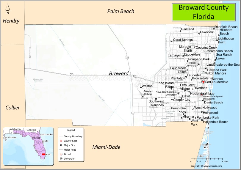
About Broward County Map, Florida: The map showing the county boundary, county seat, major cities, highways, water bodies and neighbouring counties.
Most Viewed Links
About Broward County, Florida
Broward County is located in the southeastern part of Florida, in the state of the United States. The county was established in 1915 and was named after Napoleon Bonaparte Broward, a former governor of Florida. The county seat is Fort Lauderdale, which is also the largest city. Broward County is part of the Miami metropolitan area and is known for its coastal cities, diverse population, and strong tourism and service industries.
Population
According to the United States Census Bureau, the population of Broward County is 1,944,375 as recorded in the 2020 Census, and the population density is approximately 1,585 people per square mile.
Area and Geography
According to the United States Census Bureau, Broward County covers a total area of approximately 1,323 square miles (about 3,426 square kilometers), including about 1,210 square miles (3,134 square kilometers) of land and 113 square miles (293 square kilometers) of water. The county features Atlantic Ocean coastline, urbanized coastal communities, and portions of the Everglades to the west, creating a mix of metropolitan and natural landscapes.
Bordering Counties
Broward County shares boundaries with Palm Beach County to the north, Miami-Dade County to the south, Collier County to the west, and the Atlantic Ocean to the east.
Major Cities and Communities
Major cities and towns include Fort Lauderdale, Hollywood, Pembroke Pines, Coral Springs, Miramar, and Pompano Beach.
Attractions and Recreation
Broward County is known for its beaches, boating canals, and cultural attractions in Fort Lauderdale. Outdoor recreation includes waterfront activities, state parks, and access to Everglades ecosystems, while shopping districts and entertainment venues contribute to the county’s vibrant tourism sector.
Transportation
Broward County is served by Interstate 95, Interstate 75, and Florida’s Turnpike, providing major north-south connectivity. Fort Lauderdale-Hollywood International Airport supports domestic and international travel, and Port Everglades functions as a significant cruise and cargo port.
Explore more counties in Florida Counties or view the complete USA States Map section for additional geographic information.
Sources:
Population and area data sourced from the United States Census Bureau (2020 Census). General county information referenced from the Official Broward County Government Website.
Broward County Facts
| County Info | Facts |
|---|---|
| County | Broward County |
| County Seat | Fort Lauderdale |
| State | Florida |
| Country | United States |
| FIPS code | 11 |
| Established | 1915 |
| Area | 1,209 sq mi (3,131 km2) |
| Population | 1930983 |
| Density | 1597.17 |
| Formed / Origin | Miami-Dade and Palm Beach |
Ctities in Broward county
| City Name | Type | Population (2020) | Pop. Density | Area | Incorporated |
|---|---|---|---|---|---|
| Coconut Creek | City | 57,833 | 11.8 sq mi (30.5 km2) | 1967 | |
| Cooper City | City | 34,401 | 6.7 sq mi (17.3 km2) | 1959 | |
| Coral Springs | City | 134,394 | 23.9 sq mi (62.0 km2) | 1963 | |
| Dania Beach | City | 31,723 | 6.3 sq mi (16.3 km2) | 1904 | |
| Davie | Town | 105,691 | 34.2 sq mi (88.5 km2) | 1925 | |
| Deerfield Beach | City | 86,859 | 14.9 sq mi (38.7 km2) | 1925 | |
| Fort Lauderdale | City | 182,760 | 36.0 sq mi (93.3 km2) | 1911 | |
| Hallandale Beach | City | 41,217 | 4.6 sq mi (11.8 km2) | 1927 | |
| Hillsboro Beach | Town | 1,987 | 1.6 sq mi (4.2 km2) | 1939 | |
| Hollywood | City | 153,067 | 30.8 sq mi (79.8 km2) | 1925 | |
| Lauderdale Lakes | City | 35,954 | 3.6 sq mi (9.4 km2) | 1961 | |
| Lauderdale-by-the-Sea | Town | 6,198 | 1.5 sq mi (3.2 km2) | 1924 | |
| Lauderhill | City | 74,482 | 7.3 sq mi (19.0 km2) | 1959 | |
| Lazy Lake | Village | 33 | 0.1 sq mi (0.1 km2) | 1953 | |
| Lighthouse Point | City | 10,486 | 2.4 sq mi (6.2 km2) | 1956 | |
| Margate | City | 58,712 | 9.0 sq mi (23.3 km2) | 1955 | |
| Miramar | City | 134,721 | 31.0 sq mi (80.3 km2) | 1955 | |
| North Lauderdale | City | 44,794 | 3.9 sq mi (10.1 km2) | 1963 | |
| Oakland Park | City | 44,229 | 6.9 sq mi (17.9 km2) | 1929 | |
| Parkland | City | 34,670 | 10.8 sq mi (27.9 km2) | 1963 | |
| Pembroke Park | Town | 6,260 | 1.8 sq mi (4.6 km2) | 1957 | |
| Pembroke Pines | City | 171,178 | 34.4 sq mi (89.2 km2) | 1960 | |
| Plantation | City | 91,750 | 21.9 sq mi (56.8 km2) | 1953 | |
| Pompano Beach | City | 112,046 | 25.8 sq mi (66.8 km2) | 1908 | |
| Sea Ranch Lakes | Village | 540 | 0.2 sq mi (0.6 km2) | 1959 | |
| Southwest Ranches | Town | 7,607 | 13.0 sq mi (33.7 km2) | 2000 | |
| Sunrise | City | 97,335 | 18.4 sq mi (47.7 km2) | 1961 | |
| Tamarac | City | 71,897 | 11.9 sq mi (30.8 km2) | 1963 | |
| West Park | City | 15,130 | 2.1 sq mi (5.4 km2) | 2005 | |
| Weston | City | 68,107 | 26.3 sq mi (68.1 km2) | 1996 | |
| Wilton Manors | City | 11,426 | 1.9 sq mi (5.0 km2) | 1947 |
Places to Visit in Broward County
Top places to visit in Broward includes Flamingo Gardens, Hollywood Beach, Hugh Taylor Birch State, Las Olas Beach, Broward Center for the, .
Highways in Broward
Interstate 95, Interstate 75, Interstate 595 (Port Everglades Expressway), Florida's Turnpike (SR 91), Homestead Extension (SR 821), State Road 869 (Sawgrass Expressway).
Nearest Airports
Nearest airport of Broward is Fort Lauderdale–Hollywood International Airport.
- Alachua County Map
- Baker County Map
- Bay County Map
- Bradford County Map
- Brevard County Map
- Broward County Map
- Calhoun County Map
- Charlotte County Map
- Citrus County Map
- Clay County Map
- Collier County Map
- Columbia County Map
- DeSoto County Map
- Dixie County Map
- Duval County Map
- Escambia County Map
- Flagler County Map
- Franklin County Map
- Gadsden County Map
- Gilchrist County Map
- Glades County Map
- Gulf County Map
- Hamilton County Map
- Hardee County Map
- Hendry County Map
- Hernando County Map
- Highlands County Map
- Hillsborough County Map
- Holmes County Map
- Indian River County Map
- Jackson County Map
- Jefferson County Map
- Lafayette County Map
- Lake County Map
- Lee County Map
- Leon County Map
- Levy County Map
- Liberty County Map
- Madison County Map
- Manatee County Map
- Marion County Map
- Martin County Map
- Miami-Dade County Map
- Monroe County Map
- Nassau County Map
- Okaloosa County Map
- Okeechobee County Map
- Orange County Map
- Osceola County Map
- Palm Beach County Map
- Pasco County Map
- Pinellas County Map
- Polk County Map
- Putnam County Map
- St Johns County Map
- St Lucie County Map
- Santa Rosa County Map
- Sarasota County Map
- Seminole County Map
- Sumter County Map
- Suwannee County Map
- Taylor County Map
- Union County Map
- Volusia County Map
- Wakulla County Map
- Walton County Map
- Washington County Map
- Where is Miami
- Where is Hialeah
- Where is Jacksonville
- Where is Orlando
- Where is Saint Petersburg
- Where is Tampa
- Where is Alafaya
- Where is Boca Raton
- Where is Boynton Beach
- Where is Brandon
- Where is Cape Coral
- Where is Clearwater
- Where is Coral Springs
- Where is Davie
- Where is Daytona Beach
- Where is Deerfield Beach
- Where is Deltona
- Where is Doral
- Where is Fort Lauderdale
- Where is Fort Myers
- Where is Gainesville
- Where is Hollywood
- Where is Homestead
- Where is Horizon West
- Where is Kendall
- Where is Kissimmee
- Where is Lakeland
- Where is Largo
- Where is Lauderhill
- Where is Lehigh Acres
- Where is Melbourne
- Where is Miami Beach
- Where is Miami Gardens
- Where is Miramar
- Where is North Port
- Where is Palm Bay
- Where is Palm Coast
- Where is Pembroke Pines
- Where is Plantation
- Where is Poinciana
- Where is Pompano Beach
- Where is Port St. Lucie
- Where is Riverview
- Where is Spring Hill
- Where is St. Petersburg
- Where is Sunrise
- Where is Tallahassee
- Where is Tamarac
- Where is The Villages
- Where is Town 'n' Country
- Where is West Palm Beach