Orange County Map, Florida - Orange County is a county located in the U.S. state of Florida. It's county seat is Orlando.
Map of Orange County, Florida
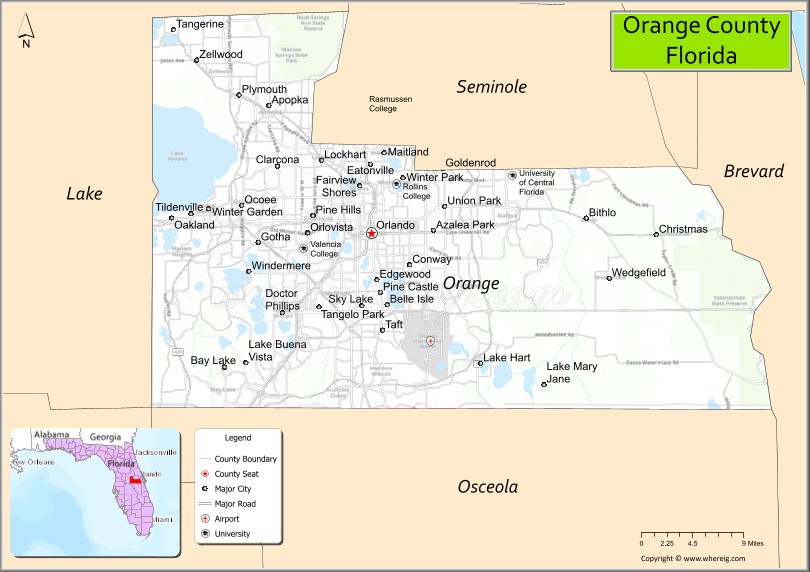
About Orange County Map, Florida: The map showing the county boundary, county seat, major cities, highways, water bodies and neighbouring counties.
Most Viewed Links
About Orange County, Florida
Orange County is located in the central part of Florida, in the state of the United States. The county was established in 1845 and was named for the region’s historic citrus industry. The county seat and largest city is Orlando. Orange County is known for its major tourism attractions, convention industry, and diverse economy centered around Central Florida.
Orange County is known for its theme parks, including Walt Disney World, Universal Orlando Resort, and SeaWorld Orlando, which draw millions of visitors each year.
Population
According to the United States Census Bureau, the population of Orange County is 1,429,908 as recorded in the 2020 Census, and the population density is approximately 1,463 people per square mile.
Area and Geography
According to the United States Census Bureau, Orange County covers a total area of approximately 1,003 square miles (about 2,598 square kilometers), including about 903 square miles (2,339 square kilometers) of land and 100 square miles (259 square kilometers) of water. The county features numerous lakes, wetlands, and urban development across Central Florida.
Bordering Counties
Orange County shares boundaries with Lake County to the northwest, Seminole County to the north, Volusia County to the northeast, Brevard County to the east, Osceola County to the south, and Polk County to the southwest.
Major Cities and Communities
Major cities and towns include Orlando, Winter Park, Apopka, Ocoee, and Maitland.
Attractions and Recreation
Orange County is internationally recognized for major theme parks, entertainment districts, and convention facilities in and around Orlando. Outdoor recreation includes lakes, parks, and nature trails throughout the county. The county is home to the University of Central Florida and Valencia College, making it a major center for higher education and research in Florida.
Transportation
Orange County is served by Interstate 4, Florida’s Turnpike, and State Road 528, providing extensive regional connectivity. Orlando International Airport supports significant domestic and international travel.
Explore more counties in Florida Counties or view the complete USA States Map section for additional geographic information.
Sources:
Population and area data sourced from the United States Census Bureau (2020 Census). General county information referenced from the Official Orange County Government Website.