Map of Palm Beach County - Palm Beach County is a county located in the U.S. state of Florida. Palm Beach County Map showing cities, highways, important places and water bodies. Get Where is Palm Beach County located in the map, major cities in Palm Beach county, population, areas, and places of interest.
Map of Palm Beach County, Florida
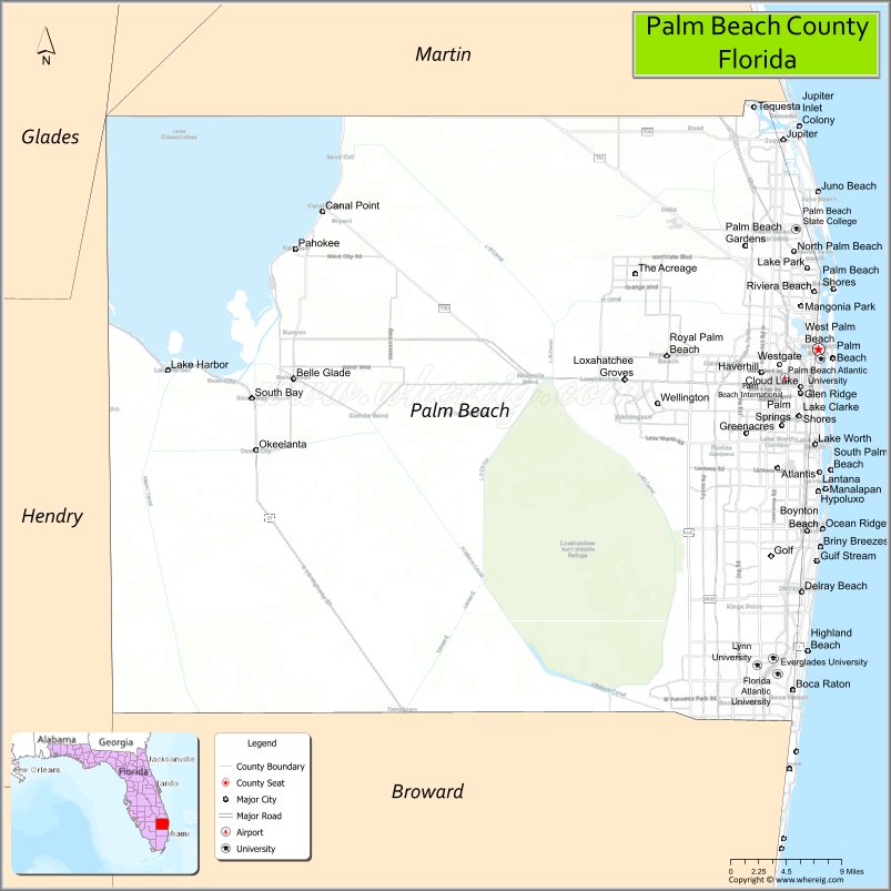
About Palm Beach County Map, Florida: The map showing the county boundary, county seat, major cities, highways, water bodies and neighbouring counties.
Most Viewed Links
About Palm Beach County, Florida
Palm Beach County is located in the southeastern part of Florida, in the state of the United States. The county was established in 1909 and was named after Palm Beach, one of its early resort communities. The county seat is West Palm Beach, which is also the largest city. Palm Beach County is part of the Miami metropolitan area and is known for its Atlantic coastline, affluent communities, and diverse economy.
Population
According to the United States Census Bureau, the population of Palm Beach County is 1,492,191 as recorded in the 2020 Census, and the population density is approximately 699 people per square mile.
Area and Geography
According to the United States Census Bureau, Palm Beach County covers a total area of approximately 2,383 square miles (about 6,171 square kilometers), including about 1,970 square miles (5,102 square kilometers) of land and 413 square miles (1,069 square kilometers) of water. The county features Atlantic Ocean coastline, barrier islands, inland wetlands, and extensive portions of the Everglades Agricultural Area.
Bordering Counties
Palm Beach County shares boundaries with Martin County to the north, Okeechobee County to the northwest, Glades County to the west, Hendry County to the southwest, and Broward County to the south.
Major Cities and Communities
Major cities and towns include West Palm Beach, Boca Raton, Boynton Beach, Delray Beach, Wellington, and Jupiter.
Attractions and Recreation
Palm Beach County offers beaches, boating, golf courses, and cultural institutions along the Atlantic coast. Parks, nature preserves, and waterfront communities support tourism and outdoor recreation. The county is home to Florida Atlantic University and Palm Beach State College, contributing to higher education and workforce development in the region.
Transportation
Palm Beach County is served by Interstate 95 and Florida’s Turnpike, providing north-south connectivity along Florida’s east coast. Palm Beach International Airport supports domestic and international air travel.
Explore more counties in Florida Counties or view the complete USA States Map section for additional geographic information.
Sources:
Population and area data sourced from the United States Census Bureau (2020 Census). General county information referenced from the Official Palm Beach County Government Website.
Facts about Palm Beach County, Florida
| Country | United States |
| State | Florida |
| Region | Southeast Florida |
| County Seat | West Palm Beach |
| Named After | Palm trees and Palm Beach barrier island |
| Established | 1909 |
| Organized | 1909 |
| Coordinates | 26.7153° N, 80.0534° W |
| Total Area | 2,383 sq mi |
| Land Area | 1,970 sq mi |
| Water Area | 413 sq mi |
| Population (2020) | 1,492,191 |
| Population Rank | Third most populous county in Florida |
| Major City | West Palm Beach |
| Main Industries | Tourism, Finance, Healthcare, Agriculture |
| Major Airport | Palm Beach International Airport |
| Time Zone | Eastern Time (UTC−05:00) |
| Known For | Atlantic beaches, upscale communities, Everglades access |
| Website | https://www.pbc.gov |
Ctities in Palm Beach county
| City Name | Type | Population (2020) | Pop. Density | Area | Incorporated |
|---|---|---|---|---|---|
| Atlantis | City | 2,142 | 1.4 sq mi (3.7 km2) | 1959 | |
| Belle Glade | City | 16,698 | 4.7 sq mi (12.1 km2) | 1928 | |
| Boca Raton | City | 97,422 | 29.1 sq mi (75.4 km2) | 1925 | |
| Boynton Beach | City | 80,380 | 16.3 sq mi (42.1 km2) | 1907 | |
| Briny Breezes | Town | 502 | 0.1 sq mi (0.3 km2) | 1963 | |
| Cloud Lake | Town | 134 | 0.1 sq mi (0.3 km2) | 1948 | |
| Delray Beach | City | 66,846 | 15.9 sq mi (41.2 km2) | 1911 | |
| Glen Ridge | Town | 217 | 0.2 sq mi (0.7 km2) | 1947 | |
| Golf | Village | 255 | 0.8 sq mi (2.2 km2) | 1957 | |
| Greenacres | City | 43,990 | 4.7 sq mi (12.1 km2) | 1926 | |
| Gulf Stream | Town | 880 | 0.8 sq mi (2.2 km2) | 1925 | |
| Haverhill | Town | 2,187 | 0.6 sq mi (1.5 km2) | 1950 | |
| Highland Beach | Town | 4,295 | 1.1 sq mi (2.9 km2) | 1949 | |
| Hypoluxo | Town | 2,687 | 0.8 sq mi (2.1 km2) | 1955 | |
| Juno Beach | Town | 3,858 | 1.9 sq mi (4.8 km2) | 1953 | |
| Jupiter | Town | 61,047 | 21.1 sq mi (54.7 km2) | 1925 | |
| Jupiter Inlet Colony | Town | 405 | 0.2 sq mi (0.6 km2) | 1959 | |
| Lake Clarke Shores | Town | 3,564 | 1.1 sq mi (2.7 km2) | 1957 | |
| Lake Park | Town | 9,047 | 2.3 sq mi (6.1 km2) | 1921 | |
| Lake Worth Beach | City | 42,219 | 6.5 sq mi (16.7 km2) | 1912 | |
| Lantana | Town | 11,504 | 2.9 sq mi (7.5 km2) | 1921 | |
| Loxahatchee Groves | Town | 3,355 | 12.5 sq mi (32.4 km2) | 2006 | |
| Manalapan | Town | 419 | 2.4 sq mi (6.3 km2) | 1931 | |
| Mangonia Park | Town | 2,142 | 0.7 sq mi (1.8 km2) | 1947 | |
| North Palm Beach | Village | 13,162 | 5.8 sq mi (15.0 km2) | 1956 | |
| Ocean Ridge | Town | 1,830 | 2.0 sq mi (5.2 km2) | 1931 | |
| Pahokee | City | 5,524 | 5.4 sq mi (14.0 km2) | 1922 | |
| Palm Beach | Town | 9,245 | 10.4 sq mi (27.0 km2) | 1911 | |
| Palm Beach Gardens | City | 59,182 | 55.3 sq mi (143.3 km2) | 1959 | |
| Palm Beach Shores | Town | 1,330 | 0.4 sq mi (1.0 km2) | 1951 | |
| Palm Springs | Village | 26,890 | 1.7 sq mi (4.3 km2) | 1957 | |
| Riviera Beach | City | 37,604 | 9.8 sq mi (25.5 km2) | 1922 | |
| Royal Palm Beach | Village | 38,932 | 10.1 sq mi (26.1 km2) | 1959 | |
| South Bay | City | 4,860 | 3.7 sq mi (9.6 km2) | 1941 | |
| South Palm Beach | Town | 1,471 | 0.3 sq mi (0.8 km2) | 1955 | |
| Tequesta | Village | 6,158 | 2.2 sq mi (5.7 km2) | 1957 | |
| Wellington | Village | 61,637 | 45.0 sq mi (116.6 km2) | 1995 | |
| Westlake | City | 906 | 6.55 sq mi (16.97 km2) | 2017 | |
| West Palm Beach | City | 117,415 | 58.2 sq mi (150.7 km2) | 1894 |
Top Attractions in Palm Beach County, Florida
- Worth Avenue – Luxury shopping and architecture.
- Flagler Museum – Gilded Age mansion and history.
- John D. MacArthur Beach State Park – Pristine beach and nature trails.
- Downtown West Palm Beach – Dining, nightlife, and waterfront.
- Lion Country Safari – Drive-through wildlife park.
- Morikami Museum and Japanese Gardens – Japanese culture and gardens.
- Jupiter Lighthouse & Museum – Scenic coastal views.
- Mounts Botanical Garden – Tropical plant collections.
- Peanut Island – Snorkeling and beaches.
- Scenic Intracoastal Waterway – Boating and waterfront views.
Highways in Palm Beach
US 441 / SR 7 (Range Line Road), Jog Road, SR 809 / CR 809, SR 807 / CR 807, US 1 (Federal Highway) / SR 5 / SR 805, SR A1A (Ocean Boulevard), US 98 (Southern Boulevard) / SR 80 / SR 700, SR 710 (Bee Line Highway).
Nearest Airports
Nearest airport of Palm Beach is Palm Beach International Airport.
- Alachua County Map
- Baker County Map
- Bay County Map
- Bradford County Map
- Brevard County Map
- Broward County Map
- Calhoun County Map
- Charlotte County Map
- Citrus County Map
- Clay County Map
- Collier County Map
- Columbia County Map
- DeSoto County Map
- Dixie County Map
- Duval County Map
- Escambia County Map
- Flagler County Map
- Franklin County Map
- Gadsden County Map
- Gilchrist County Map
- Glades County Map
- Gulf County Map
- Hamilton County Map
- Hardee County Map
- Hendry County Map
- Hernando County Map
- Highlands County Map
- Hillsborough County Map
- Holmes County Map
- Indian River County Map
- Jackson County Map
- Jefferson County Map
- Lafayette County Map
- Lake County Map
- Lee County Map
- Leon County Map
- Levy County Map
- Liberty County Map
- Madison County Map
- Manatee County Map
- Marion County Map
- Martin County Map
- Miami-Dade County Map
- Monroe County Map
- Nassau County Map
- Okaloosa County Map
- Okeechobee County Map
- Orange County Map
- Osceola County Map
- Palm Beach County Map
- Pasco County Map
- Pinellas County Map
- Polk County Map
- Putnam County Map
- St Johns County Map
- St Lucie County Map
- Santa Rosa County Map
- Sarasota County Map
- Seminole County Map
- Sumter County Map
- Suwannee County Map
- Taylor County Map
- Union County Map
- Volusia County Map
- Wakulla County Map
- Walton County Map
- Washington County Map
- Where is Miami
- Where is Hialeah
- Where is Jacksonville
- Where is Orlando
- Where is Saint Petersburg
- Where is Tampa
- Where is Alafaya
- Where is Boca Raton
- Where is Boynton Beach
- Where is Brandon
- Where is Cape Coral
- Where is Clearwater
- Where is Coral Springs
- Where is Davie
- Where is Daytona Beach
- Where is Deerfield Beach
- Where is Deltona
- Where is Doral
- Where is Fort Lauderdale
- Where is Fort Myers
- Where is Gainesville
- Where is Hollywood
- Where is Homestead
- Where is Horizon West
- Where is Kendall
- Where is Kissimmee
- Where is Lakeland
- Where is Largo
- Where is Lauderhill
- Where is Lehigh Acres
- Where is Melbourne
- Where is Miami Beach
- Where is Miami Gardens
- Where is Miramar
- Where is North Port
- Where is Palm Bay
- Where is Palm Coast
- Where is Pembroke Pines
- Where is Plantation
- Where is Poinciana
- Where is Pompano Beach
- Where is Port St. Lucie
- Where is Riverview
- Where is Spring Hill
- Where is St. Petersburg
- Where is Sunrise
- Where is Tallahassee
- Where is Tamarac
- Where is The Villages
- Where is Town 'n' Country
- Where is West Palm Beach