Map of Gadsden County - Gadsden County is a county located in the U.S. state of Florida. Gadsden County Map showing cities, highways, important places and water bodies. Get Where is Gadsden County located in the map, major cities in Gadsden county, population, areas, and places of interest.
Map of Gadsden County, Florida
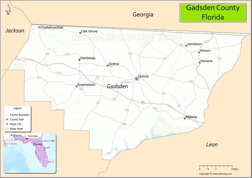
About Gadsden County Map, Florida: The map showing the county boundary, county seat, major cities, highways, water bodies and neighbouring counties.
Most Viewed Links
About Gadsden County, Florida
Gadsden County is located in the northwestern part of Florida, in the state of the United States. The county was established in 1823 and was named after James Gadsden, a military officer and diplomat. The county seat is Quincy, and the largest city is Quincy. Gadsden County is known for its agricultural heritage, historic communities, and proximity to the state capital region.
Population
According to the United States Census Bureau, the population of Gadsden County is 43,826 as recorded in the 2020 Census, and the population density is approximately 85 people per square mile.
Area and Geography
According to the United States Census Bureau, Gadsden County covers a total area of approximately 529 square miles (about 1,370 square kilometers), including about 516 square miles (1,337 square kilometers) of land and 13 square miles (34 square kilometers) of water. The county features rolling hills, farmland, and river systems that distinguish it from much of Florida’s flatter terrain.
Bordering Counties
Gadsden County shares boundaries with Georgia to the north, Jackson County to the west, Liberty County to the south, and Leon County to the east.
Major Cities and Communities
Major cities and towns include Quincy, Chattahoochee, Gretna, Havana, and Midway.
Attractions and Recreation
Gadsden County offers parks, historic districts, and outdoor recreation opportunities along its rivers and lakes. The county’s historic downtown Quincy reflects its architectural heritage. Tallahassee Community College serves residents in the region and supports higher education access nearby.
Transportation
Gadsden County is served by Interstate 10, which runs east-west across the county, and U.S. Highway 90, providing regional connectivity within the Florida Panhandle and access to neighboring states.
Explore more counties in Florida Counties or view the complete USA States Map section for additional geographic information.
Sources:
Population and area data sourced from the United States Census Bureau (2020 Census). General county information referenced from the Official Gadsden County Government Website.
Facts about Gadsden County, Florida
| Country | United States |
| State | Florida |
| Region | North Florida (Big Bend) |
| County Seat | Quincy |
| Named After | James Gadsden |
| Established | 1823 |
| Organized | 1823 |
| Coordinates | 30.5790° N, 84.6127° W |
| Total Area | 529 sq mi |
| Land Area | 516 sq mi |
| Water Area | 13 sq mi |
| Population (2020) | 43,826 |
| Population Rank | Mid-sized county in North Florida |
| Major City | Quincy |
| Main Industries | Agriculture, Manufacturing, Education, Government |
| Major Airport | Tallahassee International Airport (nearby) |
| Time Zone | Eastern Time (UTC−05:00) |
| Known For | Historic tobacco industry, Lake Talquin, civil rights history |
| Website | https://www.gadsdencountyfl.gov |
Ctities in Gadsden county
| City Name | Type | Population (2020) | Pop. Density | Area | Incorporated |
|---|---|---|---|---|---|
| Chattahoochee | City | 2,955 | 5.7 sq mi (14.6 km2) | 1921 | |
| Greensboro | Town | 461 | 1.0 sq mi (2.6 km2) | 1911 | |
| Gretna | City | 1,357 | 1.9 sq mi (4.9 km2) | 1908 | |
| Havana | Town | 1,707 | 1.9 sq mi (4.8 km2) | 1907 | |
| Midway | City | 3,537 | 3.8 sq mi (9.9 km2) | 1986 | |
| Quincy | City | 7,970 | 7.6 sq mi (19.7 km2) | 1828 |
Top Attractions in Gadsden County, Florida
- Lake Talquin State Forest – Hiking, fishing, and camping.
- Lake Talquin State Park – Boating and scenic lake views.
- Quincy Downtown Historic District – Shops and historic homes.
- Gadsden County Courthouse – Historic courthouse landmark.
- Garden of Eden Trail – Hiking trail and overlooks.
- Pat Thomas Park at Hopkins Landing – Boat ramp and river access.
- Lake Talquin Dam – Scenic views and fishing.
- Chattahoochee River Areas – Canoeing and wildlife viewing.
- Quincy Music Theatre – Local performances.
- Scenic Rural Drives – Rolling farmland and forest views.
Highways in Gadsden
Interstate 10, US 90, US 90, US 27, State Road 12 , State Road 65, State Road 159, Georgia State Route 309.
Nearest Airports
Nearest airport of Gadsden is Quincy Municipal Airport.
- Alachua County Map
- Baker County Map
- Bay County Map
- Bradford County Map
- Brevard County Map
- Broward County Map
- Calhoun County Map
- Charlotte County Map
- Citrus County Map
- Clay County Map
- Collier County Map
- Columbia County Map
- DeSoto County Map
- Dixie County Map
- Duval County Map
- Escambia County Map
- Flagler County Map
- Franklin County Map
- Gadsden County Map
- Gilchrist County Map
- Glades County Map
- Gulf County Map
- Hamilton County Map
- Hardee County Map
- Hendry County Map
- Hernando County Map
- Highlands County Map
- Hillsborough County Map
- Holmes County Map
- Indian River County Map
- Jackson County Map
- Jefferson County Map
- Lafayette County Map
- Lake County Map
- Lee County Map
- Leon County Map
- Levy County Map
- Liberty County Map
- Madison County Map
- Manatee County Map
- Marion County Map
- Martin County Map
- Miami-Dade County Map
- Monroe County Map
- Nassau County Map
- Okaloosa County Map
- Okeechobee County Map
- Orange County Map
- Osceola County Map
- Palm Beach County Map
- Pasco County Map
- Pinellas County Map
- Polk County Map
- Putnam County Map
- St Johns County Map
- St Lucie County Map
- Santa Rosa County Map
- Sarasota County Map
- Seminole County Map
- Sumter County Map
- Suwannee County Map
- Taylor County Map
- Union County Map
- Volusia County Map
- Wakulla County Map
- Walton County Map
- Washington County Map
- Where is Miami
- Where is Hialeah
- Where is Jacksonville
- Where is Orlando
- Where is Saint Petersburg
- Where is Tampa
- Where is Alafaya
- Where is Boca Raton
- Where is Boynton Beach
- Where is Brandon
- Where is Cape Coral
- Where is Clearwater
- Where is Coral Springs
- Where is Davie
- Where is Daytona Beach
- Where is Deerfield Beach
- Where is Deltona
- Where is Doral
- Where is Fort Lauderdale
- Where is Fort Myers
- Where is Gainesville
- Where is Hollywood
- Where is Homestead
- Where is Horizon West
- Where is Kendall
- Where is Kissimmee
- Where is Lakeland
- Where is Largo
- Where is Lauderhill
- Where is Lehigh Acres
- Where is Melbourne
- Where is Miami Beach
- Where is Miami Gardens
- Where is Miramar
- Where is North Port
- Where is Palm Bay
- Where is Palm Coast
- Where is Pembroke Pines
- Where is Plantation
- Where is Poinciana
- Where is Pompano Beach
- Where is Port St. Lucie
- Where is Riverview
- Where is Spring Hill
- Where is St. Petersburg
- Where is Sunrise
- Where is Tallahassee
- Where is Tamarac
- Where is The Villages
- Where is Town 'n' Country
- Where is West Palm Beach