Map of Jackson County - Jackson County is a county located in the U.S. state of Florida. Jackson County Map showing cities, highways, important places and water bodies. Get Where is Jackson County located in the map, major cities in Jackson county, population, areas, and places of interest.
Map of Jackson County, Florida
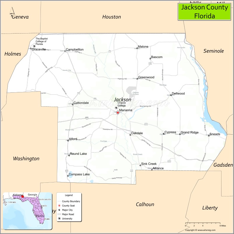
About Jackson County Map, Florida: The map showing the county boundary, county seat, major cities, highways, water bodies and neighbouring counties.
Most Viewed Links
About Jackson County, Florida
Jackson County is located in the northwestern part of Florida, in the state of the United States. The county was established in 1822 and was named after Andrew Jackson, the seventh President of the United States. The county seat and largest city is Marianna. Jackson County is known for its agricultural heritage, historic communities, and natural attractions in the Florida Panhandle.
Population
According to the United States Census Bureau, the population of Jackson County is 49,967 as recorded in the 2020 Census, and the population density is approximately 55 people per square mile.
Area and Geography
According to the United States Census Bureau, Jackson County covers a total area of approximately 955 square miles (about 2,473 square kilometers), including about 918 square miles (2,377 square kilometers) of land and 37 square miles (96 square kilometers) of water. The county features rolling hills, farmland, rivers, and caves, distinguishing it from flatter areas of Florida.
Bordering Counties
Jackson County shares boundaries with Alabama to the north, Holmes County to the west, Washington County to the south, Calhoun County to the southeast, Gulf County to the south, Liberty County to the east, and Gadsden County to the northeast.
Major Cities and Communities
Major cities and towns include Marianna, Graceville, Malone, Sneads, and Cottondale.
Attractions and Recreation
Jackson County offers outdoor recreation at Florida Caverns State Park, known for its limestone caves and hiking trails. Rivers and parks throughout the county support boating, fishing, and camping. Chipola College provides higher education opportunities and contributes to workforce development in the region.
Transportation
Jackson County is served by Interstate 10, which runs east-west across the county, and U.S. Highway 231, providing north-south connectivity. These routes link the county to neighboring states and communities across the Florida Panhandle.
Explore more counties in Florida Counties or view the complete USA States Map section for additional geographic information.
Sources:
Population and area data sourced from the United States Census Bureau (2020 Census). General county information referenced from the Official Jackson County Government Website.
Facts about Jackson County, Florida
| Country | United States |
| State | Florida |
| Region | Florida Panhandle |
| County Seat | Marianna |
| Named After | Andrew Jackson |
| Established | 1822 |
| Organized | 1822 |
| Coordinates | 30.7926° N, 85.2150° W |
| Total Area | 955 sq mi |
| Land Area | 918 sq mi |
| Water Area | 37 sq mi |
| Population (2020) | 47,319 |
| Population Rank | Mid-sized county in the Florida Panhandle |
| Major City | Marianna |
| Main Industries | Agriculture, Corrections, Manufacturing, Education |
| Major Airport | Marianna Municipal Airport |
| Time Zone | Central Time (UTC−06:00) |
| Known For | Florida Caverns State Park, Chipola River, caves |
| Website | https://www.jacksoncountyfl.net |
Ctities in Jackson county
| City Name | Type | Population (2020) | Pop. Density | Area | Incorporated |
|---|---|---|---|---|---|
| Alford | Town | 484 | 1.3 sq mi (3.4 km2) | 1911 | |
| Bascom | Town | 87 | 0.2 sq mi (0.5 km2) | 1961 | |
| Campbellton | Town | 191 | 0.9 sq mi (2.3 km2) | 1925 | |
| Cottondale | Town | 848 | 1.7 sq mi (4.4 km2) | 1905 | |
| Graceville | City | 2,153 | 4.4 sq mi (11.4 km2) | 1902 | |
| Grand Ridge | Town | 882 | 2.3 sq mi (5.8 km2) | 1951 | |
| Greenwood | Town | 539 | 4.8 sq mi (12.4 km2) | 1927 | |
| Jacob City | City | 217 | 3.2 sq mi (8.3 km2) | 1983 | |
| Malone | Town | 1,959 | 3.1 sq mi (8.1 km2) | 1911 | |
| Marianna | City | 6,245 | 8.0 sq mi (20.9 km2) | 1825 | |
| Sneads | Town | 1,699 | 4.6 sq mi (12.0 km2) | 1894 | |
| Bridgeport | City | 2,264 | 513.4/sq mi (198.2/km2) | 4.41 sq mi (11.4 km2) | |
| Dutton | Town | 330 | 383.7/sq mi (148.2/km2) | 0.86 sq mi (2.2 km2) | |
| Hollywood | Town | 914 | 102.5/sq mi (39.6/km2) | 8.92 sq mi (23.1 km2) | |
| Hytop | Town | 441 | 194.3/sq mi (75.0/km2) | 2.27 sq mi (5.9 km2) | |
| Langston | Town | 265 | 53.8/sq mi (20.8/km2) | 4.93 sq mi (12.8 km2) | |
| Paint Rock | Town | 182 | 423.3/sq mi (163.4/km2) | 0.43 sq mi (1.1 km2) | |
| Pisgah | Town | 681 | 141.9/sq mi (54.8/km2) | 4.8 sq mi (12.4 km2) | |
| Pleasant Groves | Town | 426 | 116.7/sq mi (45.1/km2) | 3.65 sq mi (9.5 km2) | |
| Scottsboro | City | 15,578 | 307.6/sq mi (118.8/km2) | 50.65 sq mi (131.2 km2) | |
| Section | Town | 756 | 165.4/sq mi (63.9/km2) | 4.57 sq mi (11.8 km2) | |
| Skyline | Town | 834 | 209.0/sq mi (80.7/km2) | 3.99 sq mi (10.3 km2) | |
| Stevenson | City | 1,955 | 253.2/sq mi (97.8/km2) | 7.72 sq mi (20 km2) | |
| Woodville | Town | 746 | 112.7/sq mi (43.5/km2) | 6.62 sq mi (17.1 km2) |
Top Attractions in Jackson County, Florida
- Florida Caverns State Park – Guided cave tours and trails.
- Chipola River – Canoeing, fishing, and river scenery.
- Downtown Marianna – Historic shops and local charm.
- Jackson County Courthouse – Historic courthouse landmark.
- Battle of Marianna Site – Civil War history marker.
- Indian Springs Golf Club – Public golf course.
- Blue Springs Recreation Area – Swimming and picnicking.
- Hinson Conservation Area – Hiking and wildlife viewing.
- Three Rivers State Park (nearby) – Lake and river recreation.
- Scenic Rural Drives – Farmland and forest views.
Highways in Jackson
Interstate 10, US 90, US 231, State Road 2 , State Road 69 , State Road 71.
Nearest Airports
Nearest airport of Jackson is Marianna Municipal Airport.
- Alachua County Map
- Baker County Map
- Bay County Map
- Bradford County Map
- Brevard County Map
- Broward County Map
- Calhoun County Map
- Charlotte County Map
- Citrus County Map
- Clay County Map
- Collier County Map
- Columbia County Map
- DeSoto County Map
- Dixie County Map
- Duval County Map
- Escambia County Map
- Flagler County Map
- Franklin County Map
- Gadsden County Map
- Gilchrist County Map
- Glades County Map
- Gulf County Map
- Hamilton County Map
- Hardee County Map
- Hendry County Map
- Hernando County Map
- Highlands County Map
- Hillsborough County Map
- Holmes County Map
- Indian River County Map
- Jackson County Map
- Jefferson County Map
- Lafayette County Map
- Lake County Map
- Lee County Map
- Leon County Map
- Levy County Map
- Liberty County Map
- Madison County Map
- Manatee County Map
- Marion County Map
- Martin County Map
- Miami-Dade County Map
- Monroe County Map
- Nassau County Map
- Okaloosa County Map
- Okeechobee County Map
- Orange County Map
- Osceola County Map
- Palm Beach County Map
- Pasco County Map
- Pinellas County Map
- Polk County Map
- Putnam County Map
- St Johns County Map
- St Lucie County Map
- Santa Rosa County Map
- Sarasota County Map
- Seminole County Map
- Sumter County Map
- Suwannee County Map
- Taylor County Map
- Union County Map
- Volusia County Map
- Wakulla County Map
- Walton County Map
- Washington County Map
- Where is Miami
- Where is Hialeah
- Where is Jacksonville
- Where is Orlando
- Where is Saint Petersburg
- Where is Tampa
- Where is Alafaya
- Where is Boca Raton
- Where is Boynton Beach
- Where is Brandon
- Where is Cape Coral
- Where is Clearwater
- Where is Coral Springs
- Where is Davie
- Where is Daytona Beach
- Where is Deerfield Beach
- Where is Deltona
- Where is Doral
- Where is Fort Lauderdale
- Where is Fort Myers
- Where is Gainesville
- Where is Hollywood
- Where is Homestead
- Where is Horizon West
- Where is Kendall
- Where is Kissimmee
- Where is Lakeland
- Where is Largo
- Where is Lauderhill
- Where is Lehigh Acres
- Where is Melbourne
- Where is Miami Beach
- Where is Miami Gardens
- Where is Miramar
- Where is North Port
- Where is Palm Bay
- Where is Palm Coast
- Where is Pembroke Pines
- Where is Plantation
- Where is Poinciana
- Where is Pompano Beach
- Where is Port St. Lucie
- Where is Riverview
- Where is Spring Hill
- Where is St. Petersburg
- Where is Sunrise
- Where is Tallahassee
- Where is Tamarac
- Where is The Villages
- Where is Town 'n' Country
- Where is West Palm Beach