Map of Seminole County - Seminole County is a county located in the U.S. state of Florida. Seminole County Map showing cities, highways, important places and water bodies. Get Where is Seminole County located in the map, major cities in Seminole county, population, areas, and places of interest.
Map of Seminole County, Florida
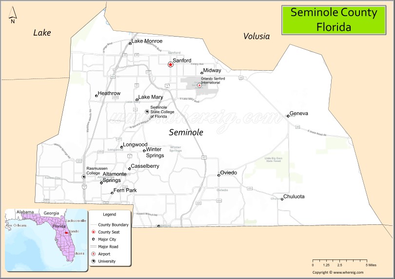
About Seminole County Map, Florida: The map showing the county boundary, county seat, major cities, highways, water bodies and neighbouring counties.
Most Viewed Links
About Seminole County, Florida
Seminole County is located in the central part of Florida, in the state of the United States. The county was established in 1913 and was named after the Seminole people, a Native American tribe historically associated with Florida. The county seat and largest city is Sanford. Seminole County is part of the Orlando metropolitan area and is known for its suburban communities, business development, and educational institutions.
Population
According to the United States Census Bureau, the population of Seminole County is 470,856 as recorded in the 2020 Census, and the population density is approximately 1,515 people per square mile.
Area and Geography
According to the United States Census Bureau, Seminole County covers a total area of approximately 345 square miles (about 894 square kilometers), including about 309 square miles (800 square kilometers) of land and 36 square miles (93 square kilometers) of water. The county features numerous lakes, suburban neighborhoods, and commercial corridors that contribute to its residential and economic growth.
Bordering Counties
Seminole County shares boundaries with Volusia County to the northeast, Orange County to the south and southwest, and Lake County to the west.
Major Cities and Communities
Major cities and towns include Sanford, Altamonte Springs, Oviedo, Casselberry, Winter Springs, and Longwood.
Attractions and Recreation
Seminole County offers parks, trails, and waterfront recreation along the St. Johns River and its many lakes. The county is also home to Seminole State College of Florida and the University of Central Florida’s satellite facilities in nearby areas, contributing to higher education and workforce development in the region.
Transportation
Seminole County is served by Interstate 4, State Road 417 (Central Florida GreeneWay), and U.S. Highway 17-92, providing connectivity throughout the Orlando metropolitan region. Orlando Sanford International Airport supports commercial and charter air travel.
Explore more counties in Florida Counties or view the complete USA States Map section for additional geographic information.
Sources:
Population and area data sourced from the United States Census Bureau (2020 Census). General county information referenced from the Official Seminole County Government Website.
Facts about Seminole County, Florida
| Country | United States |
| State | Florida |
| Region | Central Florida |
| County Seat | Sanford |
| Named After | Seminole Tribe of Florida |
| Established | 1913 |
| Organized | 1913 |
| Coordinates | 28.7140° N, 81.2410° W |
| Total Area | 345 sq mi |
| Land Area | 309 sq mi |
| Water Area | 36 sq mi |
| Population (2020) | 470,856 |
| Population Rank | One of the most densely populated counties in Florida |
| Major City | Sanford |
| Main Industries | Technology, Healthcare, Education, Professional Services |
| Major Airport | Orlando Sanford International Airport |
| Time Zone | Eastern Time (UTC−05:00) |
| Known For | Suburban communities, tech corridor, natural springs |
| Website | https://www.seminolecountyfl.gov |
Ctities in Seminole county
| City Name | Type | Population (2020) | Pop. Density | Area | Incorporated |
|---|---|---|---|---|---|
| Altamonte Springs | City | 46,231 | 9.5 sq mi (25 km2) | 1920 | |
| Casselberry | City | 28,794 | 7.1 sq mi (18.4 km2) | 1940 | |
| Lake Mary | City | 16,798 | 9.7 sq mi (25.0 km2) | 1973 | |
| Longwood | City | 15,087 | 5.6 sq mi (14.5 km2) | 1875 | |
| Oviedo | City | 40,059 | 15.4 sq mi (40.0 km2) | 1925 | |
| Sanford | City | 61,051 | 22.6 sq mi (58.5 km2) | 1877 | |
| Winter Springs | City | 38,342 | 14.4 sq mi (37.6 km2) | 1959 |
Top Attractions in Seminole County, Florida
- Wekiwa Springs State Park – Clear springs and hiking.
- Sanford Historic Downtown – Shops, dining, and riverfront.
- Central Florida Zoo & Botanical Gardens – Zoo and gardens.
- Lake Monroe – Boating and scenic views.
- Seminole Wekiva Trail – Biking and walking path.
- Black Bear Wilderness Area – Hiking and wildlife.
- Crane’s Roost Park – Lakeside park and events.
- Seminole County Courthouse – Historic courthouse landmark.
- Little Big Econ State Forest – Trails and river scenery.
- Scenic River & Spring Drives – Natural Central Florida views.
Highways in Seminole
US 17/US 92, SR 46, CR 46A, SR 414, SR 415, SR 419, SR 426, CR 427, SR 434, SR 436.
Nearest Airports
Nearest airport of Seminole is Orlando Sanford International Airport.
- Alachua County Map
- Baker County Map
- Bay County Map
- Bradford County Map
- Brevard County Map
- Broward County Map
- Calhoun County Map
- Charlotte County Map
- Citrus County Map
- Clay County Map
- Collier County Map
- Columbia County Map
- DeSoto County Map
- Dixie County Map
- Duval County Map
- Escambia County Map
- Flagler County Map
- Franklin County Map
- Gadsden County Map
- Gilchrist County Map
- Glades County Map
- Gulf County Map
- Hamilton County Map
- Hardee County Map
- Hendry County Map
- Hernando County Map
- Highlands County Map
- Hillsborough County Map
- Holmes County Map
- Indian River County Map
- Jackson County Map
- Jefferson County Map
- Lafayette County Map
- Lake County Map
- Lee County Map
- Leon County Map
- Levy County Map
- Liberty County Map
- Madison County Map
- Manatee County Map
- Marion County Map
- Martin County Map
- Miami-Dade County Map
- Monroe County Map
- Nassau County Map
- Okaloosa County Map
- Okeechobee County Map
- Orange County Map
- Osceola County Map
- Palm Beach County Map
- Pasco County Map
- Pinellas County Map
- Polk County Map
- Putnam County Map
- St Johns County Map
- St Lucie County Map
- Santa Rosa County Map
- Sarasota County Map
- Seminole County Map
- Sumter County Map
- Suwannee County Map
- Taylor County Map
- Union County Map
- Volusia County Map
- Wakulla County Map
- Walton County Map
- Washington County Map
- Where is Miami
- Where is Hialeah
- Where is Jacksonville
- Where is Orlando
- Where is Saint Petersburg
- Where is Tampa
- Where is Alafaya
- Where is Boca Raton
- Where is Boynton Beach
- Where is Brandon
- Where is Cape Coral
- Where is Clearwater
- Where is Coral Springs
- Where is Davie
- Where is Daytona Beach
- Where is Deerfield Beach
- Where is Deltona
- Where is Doral
- Where is Fort Lauderdale
- Where is Fort Myers
- Where is Gainesville
- Where is Hollywood
- Where is Homestead
- Where is Horizon West
- Where is Kendall
- Where is Kissimmee
- Where is Lakeland
- Where is Largo
- Where is Lauderhill
- Where is Lehigh Acres
- Where is Melbourne
- Where is Miami Beach
- Where is Miami Gardens
- Where is Miramar
- Where is North Port
- Where is Palm Bay
- Where is Palm Coast
- Where is Pembroke Pines
- Where is Plantation
- Where is Poinciana
- Where is Pompano Beach
- Where is Port St. Lucie
- Where is Riverview
- Where is Spring Hill
- Where is St. Petersburg
- Where is Sunrise
- Where is Tallahassee
- Where is Tamarac
- Where is The Villages
- Where is Town 'n' Country
- Where is West Palm Beach